Tuesday, February 28, 2012

Valles Canyon - Sierra de las Uvas


I haven't been here in several years, but this used to be one of my favorite places to visit. It was a definite destination for out of towners as well. The reason: it was a short easy walk to a couple of fantastic petroglyph sites. The old way ( as described in Greg Magee's Hiking Guide to Dona Ana County) to get in here was to take the Barksdale Road from NM 185 just north of Border Patrol checkpoint. The first pitch down into Broad Canyon ( about 10 miles in)was always pretty terrifying: steep,narrow,rough and with a substantial drop-off should you go over the edge, I remember steeling my nerves for every descent and ascent. At a subsequent crossing of Broad Canyon we had to find a place to park,then slip under a barbed wire fence( my mom loved that) and walk downstream to the confluence with Valles Canyon. I remember being so amazed and delighted when we started seeing the petroglyphs and grinding holes here. I could hardly believe we could just come out here and wander around on our lonesome at an archaeological site. Back in the east where I come from, it seems that anything of any interest has got a fence around it , three guides breathing down your neck, and 500 other people paying for the privilege of seeing whatever it might be. We walked up Valles Canyon a short ways and it only got better. The rock art here was much more accomplished( and most likely much older ).
 The new way ( as described in Greg Magee's Day Hikes and Nature Walks in the Las Cruces- El Paso Area)of getting here is from the west. The hike starts at a large clearing off the (paved) Corralitos Road know as Valles Tank where there is a corral and ample room to park. Some of the cows out here look a little wild and ornery,so keep your head up. There is one spot where it may be necessary to climb down a small dry waterfall( I'm glad I took my parents the old way).  There is also fence across the stream bed.Look for a gate on the south side instead of crawling under Even though this is a longer hike, it should be the one you use if you visit. I think it is the preferred route now because of private property issues involved using the old way.NOTE: forgive the image quality. These were all taken many years ago with an Advantix film camera. On subsequent visit I have been either without camera or just not taking photos for reasons I can't quite explain.


Labels: , ,

Monday, February 27, 2012

Picacho Mountain(Peak)- Box Canyon


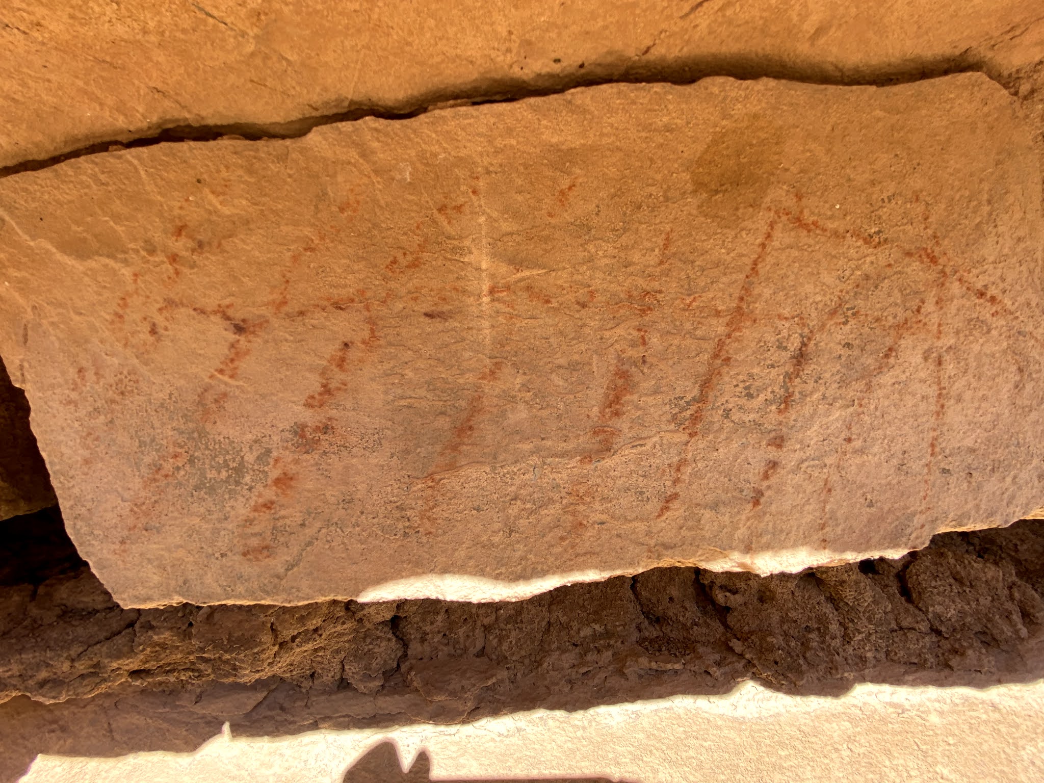
I've visited each of these places once, even though they are very close to Las Cruces. We hiked Box Canyon that runs along the north side of Picacho Peak back when we first moved here in '98 or '99. Didn't take any photos and don't remember much,except sticking close to the canyon walls for shade. A friend of mine recently told me about some perennial springs in Spring Canyon which is small tributary of Box Canyon. I thought it would make a nice little late winter, after lunch day hike. Seamus (my Scottie dog) and I started out from the parking area at the top of the mesa,before the road descends roughly into the canyon. We had walked less than a mile when we saw and heard some folks standing on the dam popping off round after round from their pistol. Call me overly cautious, or whatever you like,but I don't want be anywhere near young men shooting off guns. Once again, just like my experience in another part of the Robledos, they didn't seem to be shooting at anything( like a target) or being particularly consistent or careful as to the direction they were shooting. I have to say this kind of activity,so close to residential areas, and with bicycle riders, horse riders,hikers with pets and children frequenting the area, is just not appropriate. It may be legal,but that doesn't make it right.Oh well, if I ever visit this area again, I'll go on a weekday. It is pretty scenic but on the weekend there's too many people and too many bullets flying. And if I want to go to those springs, I'll visit in the late fall and hike in from the west side and avoid the main road and the dam area altogether.
      I climbed Picacho Peak a few years back,starting from the lower Apache Dam walking along the road , and then crossing over the narrow ridge into the lower end of the above mentioned Box Canyon.We then went cross country up the north side of the mountain,which is quite steep, achieving the peak in short order. We descended using the road that's on the east side which leads directly over the ridge and back into Apache Canyon and to the dam. On my way back from my recent trip I saw about 20 or more Texans, who for some reason had each driven their own car up from El Paso( I assume), parked along the road getting ready to start a hike. I thought to myself that the Robledo Mountains area is suffering from the same problems as the Organ Mountains do on weekends: too many people, irresponsible people, and conflicting recreation agendas. Still, I've enjoyed many hikes here in near or complete solitude even while walking on roads. The problem in the Robledos is that "net" of roads and jeep trail. More and more people are using them. And where vehicles go, trash and problems follow.  I hope my imagination is up to the task of finding more obscure locations here for my adventures otherwise I might have to retire the Robledos altogether, but I believe I'm pretty much done with the obvious locations, at least until the management of these place experiences a major overhaul. Note: there are many routes to climbing Picacho Peak. Directions to this area and a route for a loop hike to both of these spots are in Greg Magee's Day Hikes and Nature Walks in the Las Cruces - El Paso Area.

Labels: ,

Sunday, February 26, 2012

Tres Hermanas

I've been to the Tres Hermanas Mountains south of Deming a couple of times, back in the late nineties and early 2000's, mostly just to poke around the old mines on the west side of the range, but one time we climbed one of the smaller satellite peaks( not one of the "three sisters"). There is pretty good dirt road that takes off from NM 11 right where it turns to east ( if you're headed south). At one point it passes through a corral area, which felt like we were entering private property, but I'm pretty sure it isn't.The group of mines and prospects here are called "Mahoney Mines" on the topo map. There are a lot of holes in the ground here. There's also lots of strange looking waste rock. We've collected a few specimens for landscaping. Jeep trails and old roads wind around the narrow passages between the steep peaks and other little mines and prospects are everywhere. None of them look like they ever made anybody rich. I would like to do more exploring here, but it's a little too far from home for day trips with the price of gas the way it is. One destination that has me intrigued is a spurrite desposit and nearby cave with fluorescent minerals (Tres Hermanas Cave, I believe) on South Sister Peak. One time I tried to find the dirt road to it from NM 11 and it looked liked a pretty straight shot to the South Peak, but in the days before having a GPS, I wasn't sure I'd found it. Even today with GPS points I've still have ended up on the wrong set of tracks in the desert.In New Mexico it seems there are always more roads than on the topo map. Well, maybe next time I'm camping at Rockhound, the Tres Hermanas or the Mahoney Park area of the Floridas would be good for a day hike.

Labels: ,

Thursday, February 23, 2012

Apache Canyon Update (1/30/21), Robledo Mountains- Prehistoric Trackways National Monument

 Atl atl thrower (?) and  turtle  pictographs
Just a few more photos from our Apache Canyon hike. UPDATE (1/30/21): Revisited this site after 9 years with friends David and Nancy Soules, only this time took a shorter route starting from the west, where we ended up hitting the canyon upstream from the jeep road crossing near an old tank and then hiked downstream about a mile. I had forgotten, as I walked over limestone bedrock, gazed up at impressive cliffs, and marveled at huge juniper trees, what a beautiful canyon experience this was, and is. I highly recommend it.


Labels: , , , ,

Wednesday, February 22, 2012

Prehistoric Trackways National Monument - Apache Canyon

Basalt plug

I'd been out here once before. I'd read about the volcanic plug of basalt and had wanted to see it. This time out I wanted get some photos of it. I started off from the Apache Canyon Dam, which is accessed from Shalem Colony Road and Skyline Drive. After crawling under the closed gate, I walked down the steep embankment. To the right there is road that goes up steeply to the mesa. I took it. It also is possible to walk across the dam and take the first road to the right up the lower end of Apache Canyon. Be forewarned though: the lower end of Apache Canyon is an unappealing eco-disaster area with an  on and off again sand and gravel operation and an abandoned cement plant. In addition the overgrazing has been extreme throughout the area.
   Following the road on the mesa is a better option. After a mile or so, another road branches to the north toward the large (closed) quarry. A short way after that the road seems to dead end in a small arroyo. Really the arroyo is the road for a short ways. We picked the road up again and followed it up several hills and then down to a three way intersection. Here there are large conglomerate boulders scattered about. In the sand of small gullies were sparkling white specimens of gypsum. We (my Scottie Seamus and I) scrambled up a low ridge and down a brushy gully to get into Apache Canyon proper. From there we headed north past the little black peak up the canyon.This is where the best part of our walk began.
  There are many, many roads in the Robledos, some very old,  others of a more recent vintage,but most stay on hilltops, if you want to see the best of these mountains, get down in the canyons.The plant communities are certainly more diverse and the surprisingly large junipers will provide periodic shade.The canyon bottom alternates from gravel and boulders to long stretches of bare, tilted limestone slabs. Some have abundant marine fossils( brachiopods, mollusks and crinoids(?)) There are small, in-situ geodes as well.Further along, rusty red layers of shale lined both sides of the canyon. I saw imprints of plants and even a few tracks. I just kept wanting to go on to see what else this canyon could show me. When I finally decided to turn around at one of those large dry water falls of tilted, thick layers of sedimentary rock, so typical in the Robledos, I spotted a few red pictographs on the yellow sandstone wall.Keep in mind if you choose to hike here that many of these canyons are still open to rock crawling jeeps and other off road vehicles, and that right now(February 23rd,2012)the yearly Chile Challenge has brought over 200 of these vehicles to these mountains. Not a good time for a natural experience or solitude,but the rest of the winter you'll have the place to yourself. Update:  Apache Canyon is still open to vehicle use but the Chile Challenge no longer will utilize the Robledo Mountains.
Plant (fern?) fossil

Basalt plug

Brachiopod ( and other stuff) mash


Labels: , , , ,

Tuesday, February 21, 2012

Goat Hill Trail


Our original intention was to take a walk on the Chihuahuan Desert Nature Park's little trail. But we came upon 2 locked gates. It was closed.While I was pondering why a park that is supposed to be operating for the public's enjoyment and education would be closed on 50% of the days that public would be most likely to use it, and why they wouldn't put a sign with the park's hours a few miles back on the road,say, where there was sign that said Nature Park - 4 Miles, I drove over to nearby Goat Hill,an isolated little prominence on the northeast side of Las Cruces. We parked at a little turn around on the southeast side of the hill,and quickly found a horse and bike trail that led us around first in northerly and then northwesterly direction. There were views to to Dona Ana Mountains and the Dona Ana arroyo was directly below us. I don't believe I'd ever seen it before and was surprised at how large it was on this side of highway.The trail looped and curved around the "arms" extending out from the mountain until it dead ended between a couple of steep gullies. It's probably only a little over a mile long. At one point it crossed a gravel road that goes steeply halfway up the hill, which could be used to climb to the top. Of course there is the road on the south side that does go to the communications towers on the top, but that didn't seem too appealing to use.

Labels:

Wednesday, February 15, 2012

Aden Crater and Kilbourne Hole


Aden Crater and Kilbourne Hole are two volcanic features in southwestern Dona Ana County. They're probably less than 10 miles apart and are closer to El Paso,Texas than to Las Cruces. I've visited Aden Crater a couple of times, Kilbourne Hole once. Since these areas are so far off the beaten track,most people don't know that there are extensive areas of relatively recent lava flows( malpais) in this part of New Mexico. There is also a chain of cinder cones( the West Potrillo Mountains) and several maars- of which Kilbourne Hole is the most well known.Read this if want to know what a maar is: en.wikipedia.org/wiki/Maar . Kilbourne Hole gets quite a few visitors despite its remote location and the poor condition of the road that leads directly to the rim( you're basically driving in barely vegetated sand dunes as I recall). Some come there for the rockhounding. Others come to party. The second group likes to leave trash and shoot guns( see "Shotgun Shells" in this blog). I remember there was an old car that had been pushed over the rim on the south side. There were other large household items dumped as well. Walking away from the parking area our attention was quickly diverted to the many volcanic " bombs" that littered the ground. Some had an obsidian sheen on the outside and when broken apart are almost entirely composed of olivine, a light green mineral which when cut is the semi-precious gemstone peridot. I still have a few of these that I collected lying around. We climbed down in the yucca studded crater bottom and wandered around a bit.There was the occasional larger,loose crystal of olivine to be found, to keep things interesting.
      Aden Crater is a small cinder cone a few miles to the northwest and has a parking area in the grassland about a half mile to the west of extinct volcano itself. We picked up a trail that led us up through a break in the rough rim of dark volcanic rock. At the time of our last visit( about ten years ago) it looked like it was still possible to drive up into the crater from the northeast side.We looked around at the various forms of volcanic rock and the 100 foot deep pit in the craters center. You can see pahoehoe and aa and all that good stuff right here close to home and not have travel to Hawaii. Directions to both these places are fairly complicated. One good source for them is Greg Magee's Dayhikes and Nature Walks in Las Cruces-El Paso Area.There are resources on the internet as well. Consult with the BLM Las Cruces Office for the best information. They are the land managers for these two sites as well as almost all the surrounding terrain.These are pretty easy hikes( my parents made the one to Aden Crater) to interesting places. Just keep in mind that you probably won't have cell service, and the many dirt roads can be very confusing to navigate and can turn from decent enough for sedans to impassable to almost all vehicles if the rain comes. Don't come here in summer,not only is it unbelievably hot, it's also when that rain is most likely to catch you off guard.


Labels: , ,