 |
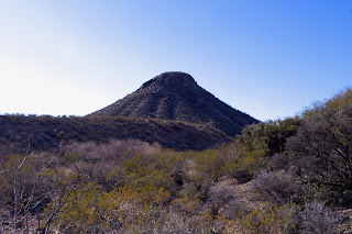
| Basalt plug |

I'd been out here once before. I'd read about the volcanic plug of basalt and had wanted to see it. This time out I wanted get some photos of it. I started off from the Apache Canyon Dam, which is accessed from Shalem Colony Road and Skyline Drive. After crawling under the closed gate, I walked down the steep embankment. To the right there is road that goes up steeply to the mesa. I took it. It also is possible to walk across the dam and take the first road to the right up the lower end of Apache Canyon. Be forewarned though: the lower end of Apache Canyon is an unappealing eco-disaster area with an on and off again sand and gravel operation and an abandoned cement plant. In addition the overgrazing has been extreme throughout the area.
Following the road on the mesa is a better option. After a mile or so, another road branches to the north toward the large (closed) quarry. A short way after that the road seems to dead end in a small arroyo. Really the arroyo is the road for a short ways. We picked the road up again and followed it up several hills and then down to a three way intersection. Here there are large conglomerate boulders scattered about. In the sand of small gullies were sparkling white specimens of gypsum. We (my Scottie Seamus and I) scrambled up a low ridge and down a brushy gully to get into Apache Canyon proper. From there we headed north past the little black peak up the canyon.This is where the best part of our walk began.
There are many, many roads in the Robledos, some very old, others of a more recent vintage,but most stay on hilltops, if you want to see the best of these mountains, get down in the canyons.The plant communities are certainly more diverse and the surprisingly large junipers will provide periodic shade.The canyon bottom alternates from gravel and boulders to long stretches of bare, tilted limestone slabs. Some have abundant marine fossils( brachiopods, mollusks and crinoids(?)) There are small, in-situ geodes as well.Further along, rusty red layers of shale lined both sides of the canyon. I saw imprints of plants and even a few tracks. I just kept wanting to go on to see what else this canyon could show me. When I finally decided to turn around at one of those large dry water falls of tilted, thick layers of sedimentary rock, so typical in the Robledos, I spotted a few red pictographs on the yellow sandstone wall.Keep in mind if you choose to hike here that many of these canyons are still open to rock crawling jeeps and other off road vehicles, and that right now(February 23rd,2012)the yearly Chile Challenge has brought over 200 of these vehicles to these mountains. Not a good time for a natural experience or solitude,but the rest of the winter you'll have the place to yourself. Update: Apache Canyon is still open to vehicle use but the Chile Challenge no longer will utilize the Robledo Mountains.
 |
| Plant (fern?) fossil |
 |
| Basalt plug |
 |
| Brachiopod ( and other stuff) mash |
Labels: fossils, hiking, Organ Mountains/Desert Peaks National Monument, pictographs, Pre-historic Trackways National Monument


 I'd been out here once before. I'd read about the volcanic plug of basalt and had wanted to see it. This time out I wanted get some photos of it. I started off from the Apache Canyon Dam, which is accessed from Shalem Colony Road and Skyline Drive. After crawling under the closed gate, I walked down the steep embankment. To the right there is road that goes up steeply to the mesa. I took it. It also is possible to walk across the dam and take the first road to the right up the lower end of Apache Canyon. Be forewarned though: the lower end of Apache Canyon is an unappealing eco-disaster area with an on and off again sand and gravel operation and an abandoned cement plant. In addition the overgrazing has been extreme throughout the area.


2 Comments:
Devon I was wondering if you could send me directions to the canyon youhiked down?
Jerry Yates 575 746 7881 yatesjerry24@gmail.com
Post a Comment
Subscribe to Post Comments [Atom]
<< Home