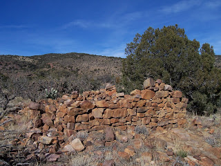
Cooke's Peak ghost town


When I last visited this area, it looked like the BLM was staking out a new road that would bypass the small section of private land at the end of the county road and allow vehicle access to the old town site and mines. As it was, we had to walk around the inholding fence line, then pick up the old road and hike the 2.5 miles up to the site.Along the way is the old town cemetery.There's not much left to this site: an old rusty car, some wooden shacks that may have fallen down by now, mine structures and a few stone walls. Still, I love to poke around places like these and let my mind wander, trying to imagine a place now so forgotten and remote bustling with human activity.
Labels: ghost towns, hiking


3 Comments:
I have been looking for the gps coordinates of the cooks peak ghost town. would you happen to have that or directions to the ghost town. Cant seem to find on any map how to get there. Thanks.
Dale
It's not hard to get to.Take NM 26 northeast of Deming. Then head northwest on County Road AO 19. This is a good road for the first several miles, but becomes low maintenance thereafter. Near an old corral the BLM has built a rough road that bypasses a small bit of fenced private property. If you have a high clearance vehicle continue driving, if not, hike up this road for a couple of miles. Remains of the town, the cemetery and the old mines are all along it.
When I was a kid, in the early 60's we used to be in the Jeep club. I remember a trip across the Corralitos Ranch to Fort Cummings. We then continued to Cooks ghost town, hiked around, found some iron pyrite (fools gold), and drove out to highway 180, and back to Las Cruces. I'm rediscovering these places in my retirement.
Post a Comment
Subscribe to Post Comments [Atom]
<< Home