Thursday, February 18, 2016

La Cienguilla Petroglyph Site


 Andrea, Seamus, Nessie and I started out for this hike on Valentine's Day morning(2/14/16). I had read about this site located near the confluence of the Santa Fe River and the Calabasas Arroyo on the BLM Taos Field Office website just a few days before while looking for some lower elevation(and hopefully snow free) hikes near Santa Fe. Getting there was easy enough. We used 599, then headed west on Airport Road which turned into Paseo Real which took us to the parking area.
 It was cloudy, windy and just a little bit cold as we started walking, following little wooden posts with painted arrows pointing the way. At first we just followed the fence line, but eventually were directed up to the basalt cliffs, from which point we were on our own as far as following an actual trail.
Climbing up and down, around and through the boulders and junipers, just going where others had left footprints,we found hundreds and hundreds of images pecked into the gray and black rock. Many were types that I had seen before down in southern New Mexico,leading me to believe that cultural contact was prevalent throughout the entire Rio Grande corridor, but others were strikingly different.
The sun eventually emerged to warm our bones, and the wind calmed for the most part, as we continued to enjoy each new  pocket of art. The images are by no means continuous along the base of the low cliffs, so persevere if you want to see more of what this site has to offer.
 More people began to arrive as the morning wore on, but it was by no means crowded, which struck me  as odd given the site's proximity and ease of access to Santa Fe, and the abundance of wonderful rock art.
We took what seemed to be the first  opportunity since we began to  make our way down very steeply on a use path that presented itself to us. Back on the valley floor, I could see we were almost to the private property boundary as well. We made our way back to the truck along the fence, and left the northern section of trail, and the mesa top for another trip.

Labels: ,

Tuesday, February 16, 2016

Arroyo del Tajo- Quebradas Backcountry Byway


pictographs rapidly disappearing

West entrance

looking back at the east entrance


 I'd been out to the  Quebradas once before while camping over at Valley of Fires. It was early March and already too hot( at least that day) for anything more than a short hike in an anonymous canyon, and few stops to take photos. I'd been wanting to get out there again since scoping a few interesting looking canyons with maps and Google Earth this summer. It turns out my friend Doug Scott already had listed the Arroyo del Tajo box/slot on his New Mexico Slot Canyons website, but he had yet to visit. He did provide a link to Southwest Backpackers little movie of a  trip to the canyon on a very cold February day a few years back. I had been trying to get Doug to come down and meet me to do this hike, but he was busy enjoying being a grandpappy on this particular weekend.
 So, off we went this past Friday(2/12/16), Seamus, Nessie and I. Coming from the south we took the San Antonio exit( #139), cruised past the famous Owl Bar and drove 11 miles east on US 380. We turned to the north on a well maintained dirt road. After about 2 miles( the first intersection), the Backcountry Byway begins and heads off to the west. This is  a well maintained dirt road and is suitable for sedans in dry weather. The road makes several near 90 degree turns, and many more bends but is generally headed north. After about 14 miles from the start of the Byway, we crossed the Arroyo del Tajo and parked at the Geologic Tour Stop 5.

 We glanced at a  few interesting looking ,deep brown, sandstone formations and then began heading west and downstream. Unfortunately, it was another unseasonably warm day and  was already 10 o'clock, so we would be walking when the winter sun was at it's maximum power, which in this shadeless dry landscape is stronger than most folks would imagine. I learned this a long time ago while hiking on a near 70 degree January day in the Sierra de las Uvas nearer to my home in Las Cruces.

 After a narrow passage through some cliffs of sedimentary rock, the Arroyo del Tajo gradually became a wide,  shallow,gravelly, mostly monotonous arroyo through low rounded hills. There were occasional junipers which were the only, and most welcome shade.Nothing about this part of the hike would prepare anyone for our destination. Coming around one more bend, I had my first sighting of the jumble of massive granitic rocks that I knew could only be the entrance to the box. I picked up the pace even more and soon we were at the eastern entrance, which is all but invisible until we were in it. There was a small puddle of green water here,which we scrambled around easily,but I had read that when it is full, it can be easily avoided with small climb on the south side( which we used on our way out).

Hidden eastern entrance


Now we were in the box. The walls of hard igneous rock soared up close to 100 feet on either side, and provided a ringing echo of our every sound. We spied a brushy, mini-slot on the north side, and high pour offs indicated by long black stains on orange hued cliffs. There were odd, hollowed out stair step dry waterfalls as well. The canyon bottom was sand and bedrock, with no vegetation whatsoever. This made sense for even as it approached the noon hour, it remained quite dark at the very floor of the slot.


All too quickly we were back out in the sun after this cool retreat.The western entrance, was not going to be manageable with dogs, so we climbed out on an easy route on the south side.
 We were now headed downstream looking for some pictographs. The canyon walls were now a sedimentary boulder conglomerate, a similar rock type that is prevalent along the Rio Grande  back in Doña Ana County where I do the majority of my desert exploring. There were some high cliffs in a big bend, and nearby on the opposite side, we found the disappearing pictographs. There were also many alcoves in rock, including a couple that were deep and dark enough to call caves, one of which Seamus seemed bent on exploring. This did not seem like a good idea at all to the human in our pack, so we  headed back upstream, after passing another unappealing pool of water with a headless jackrabbit partially submerged in it.
                                        

Mask pictograph upper left


 Back in the cool of the box canyon, we snacked and drank and listened  to the ravens talking and flapping out in the bright sun.  On the way out I admired the geologic contact where the beds of sedimentary rock were pushed back and tilted upward when the pluton was emplaced.We took our time on the way back, stopping at almost every available juniper. There was a ruin of a small stone cabin, but it hardly seemed like a place for a homestead, so I am not sure what its purpose was.We were back at the truck before 2 PM, all in good shape and spirits.


 Note: Although this hike was only about 5 1/2  to six miles roundtrip, the  box canyon  can be reached by a much shorter hike from the southeast side by parking at a windmill and tank( which are reached by a good dirt road on the south side of the Byway) and then proceeding on some old tracks down to the Arroyo del Tajo.

Labels: , ,

Tuesday, February 9, 2016

Upper Faulkner Box Canyon- Organ Mountains Desert Peaks National Monument


Seamus

the "slot"
Andrea and Nessie in the little "slot "section

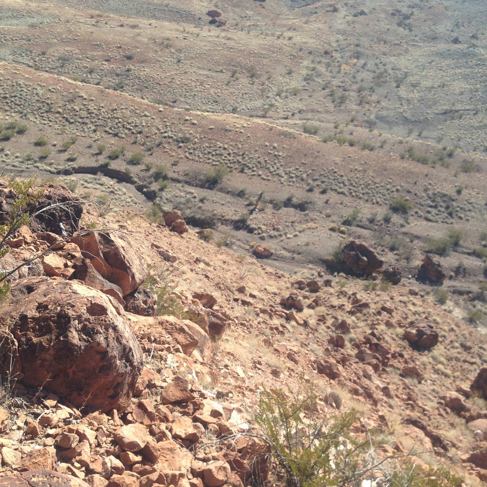
Looking down into the box
     This hike was in another neat little box canyon not far from the others I've been exploring these past few weeks. While those were tributaries of Foster Canyon, this one is a tributary on the northwest end of Faulkner Canyon, a major arroyo system to the south of Foster that divides the Robledo Mountains from the Cedar Hills. It is upstream from  a more well known box on the Faulkner's southeast side,  and from the landmark Outlaw Rock. The canyon is accessible from its mouth by driving in on the Faulkner Canyon Road, however we began our hike from near a tank at the top end which we arrived at using that same ridgetop road I've been using to access the Foster tributary hikes. A very poor spur road( high clearance only- really) that heads south got us to  our trailhead.
 We walked downstream passing rusty cliffs and boulders with junipers emerging in the spaces and cracks. There were a few dry waterfalls to climb down or  walk around. Dropping down into  a brushy narrow section,  there were  hackberry trees as well.


 The canyon opened up for awhile  and became a sandy draw bordered  at first with welded ash deposits of  white and then strange looking brown, black and greenish volcanics that had seams of some kind of blue and green copper minerals, pods of quartz and occasional globs of agate. A large ash tree, which I'm hoping will still survive, lay on its side in the sand.


 Further downstream we came the narrowest part of the box. We climbed down an awkward little dry waterfall, and found ourselves in a slot of polished pink volcanic rock that had walls just over our heads. Above us was a second tier of the red cliffs. We followed the tight watercourse, climbing down a second dry waterfall just  a short ways when it terminated at much higher pour-off that was quite sheer. A few big cliffs closed in just beyond the bottom of the falls. On one was graffiti in a garish shade of blue. Below, the spray paint can lay in the sand.  A kind of disappointing climax to our little journey, I wanted to at least pick up the can and any other trash that was down there, but there was no way to get down except to go back up, and then around and down.
 more of the mini "slot"

The  mini" slot"
 We did walk back to where we had seen a two track come in on the north side of the canyon. We used it to climb up the hill to get some views down into the box, which opened up considerably after the high dry waterfall. In the cliffs I spied a tiny, little pinhole arch. I also could  see vehicle tracks in the sandy bottom, which explains the  graffiti in this seemingly remote, hidden canyon. I believe the current generation of taggers (and perhaps the last few preceding them) for the most part are too lazy to hike but a very short distance to do their pathetic deeds.
Looking down to the high waterfall

The lower canyon
 On the return we took an alternate canyon on the north side, quite by accident, so that our hike became a lollipop loop.  Unlike almost every hike I do out in the desert, there were footprints all along our way on this warm Super Bowl Sunday.  I know that the Ocotillo hikers visit here occasionally, and accessing this canyon from the road in  Faulkner Canyon is pretty quick, with only one truly rough section if my memory serves me correctly. Still, it is unlikely you will see anyone and if they're not carrying a can of spray paint, you'll probably have a lot in common.

Labels: , ,

Tuesday, February 2, 2016

Foster Basin- Organ Mountains Desert Peaks National Monument


 Dark spot on the hill is the alcove
The weather seemed to be holding steady so I dashed out at lunchtime  on Sunday to get this little hike in before the wind really began to howl. My original plan was to hike the little box canyon that was  in between the two we used for  a loop hike a few weeks ago( see " Foster Canyon" in this blog).  And that's how things started out. I used the same dirt road that goes up on the ridge just south of Foster Canyon. This time I drove maybe mile farther and a short ways down a side road. I was hoping to drive all the way to the old impoundment we had crossed on that previous hike, but early  on the road conditions changed my mind.
 So off I went,  passing some old onyx prospects(  I'm pretty sure they were for onyx), that gave me a feeling of deja vu.  I remembered that  I have been out here  once before kicking around this old excavations. I got to the now in filled tank, and hopped down into  the arroyo and quickly went through a rocky little gate.

 I did some exploring among some boulders and cliffs that appeared immediately on the hillside to the west, including looking over the rim of the hill at a huge valley below, before going down into  the twisting and turning little canyon.


It was  a little more drab than the other two we'd explored, but still pretty nice. There was one little dry waterfall that could be walked around, and then quickly thereafter another higher one which could be climbed down very carefully. Right below was a dark little passage with a few hackberry trees.


The canyon had the same "striped" or foliated rock with beds tilted almost vertically in places, I had seen in one of the others on a previous hike. It had the look and feel of a metamorphic gneiss, but I welcome the input of any geologists out there who are familiar with the area to set me straight.

 
At the  mouth, I quickly turned to the smaller canyon right next door to the west. This one was more open and grassy and in a short ways it led back to a huge roughly circular basin, where many rills gathered in the grassy, treeless bowl to form two larger arroyos. It was  kind of like  a desert  cienega  or high country wet meadow, but without the agua or wet. I get tunnel vision sometimes looking at maps and Google Earth, focusing on one certain feature, in this case the canyon I went down, and  don't notice what lies around it, so this was all an unexpected delight.

 
I explored in the huge red boulders that tumbled down from the rim and found one with a donut hole.  Climbing up to an  large alcove, I found a little stone "table " ( really just a flat rock placed on two other rocks)inside perhaps made by someone who camped out in there one night. There also seemed to be  a red pictograph on the back wall, but I wouldn't wager money on it. As I made my way back down  the slippery grus, I picked up a piece of gray chert, that was sharply broken that I feel certain had not weathered out  of  the volcanic rock all around me.

 Now, I made my way across the basin, inspecting more boulders as I climbed toward the front side of the cliffs I had explored on the beginning of my hike. Close to the top, I looked back down and thought what a beautiful, hidden place, perhaps even majestic in that small way that  I've come to appreciate and if you visit maybe you will too.

Labels: ,