Monday, October 25, 2021

Lincoln National Forest - Fall Colors Hike


 Another awesome fall colors hike in  the Lincoln National Forest's Sacramento district!  I had thought about going to the Gila's Black Range on Sunday (10/24/21) but it still seemed a little hot for the lower elevations there and of course the mountain tops are still very open to the sun because of the Silver Fire in 2013. So at the last minute I spied a nameless canyon on Google Earth near Cloudcroft that looked to have deciduous trees lining its west side. Off we went. It was little rough on the Bailey Ridge Road ( FR 206 ) but the distance we drove on it was relatively short compared to many hikes we access with dirt or gravel forest roads. We parked at a large meadow camping area, then headed across the road to a saddle and then went steeply down the other side following a trail of sorts. There were a few berms along the way, so I believe it may have been an old jeep road that the Forest Service closed. It has been many years since any kind of vehicle has been down in the canyon.  It also seems to be currently free from livestock grazing, although we did see horses grazing in the meadows along the forest road ( FR 206 ) on the way out, so maybe they get in there from time to time. They may be wild, I'm not sure.
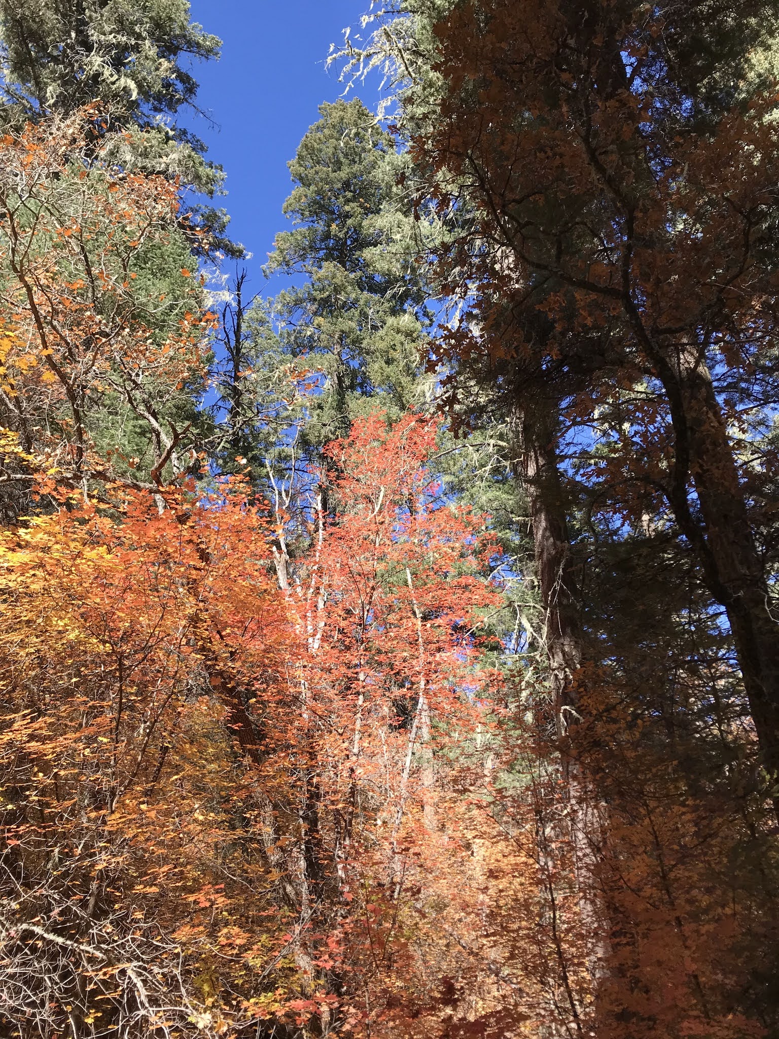
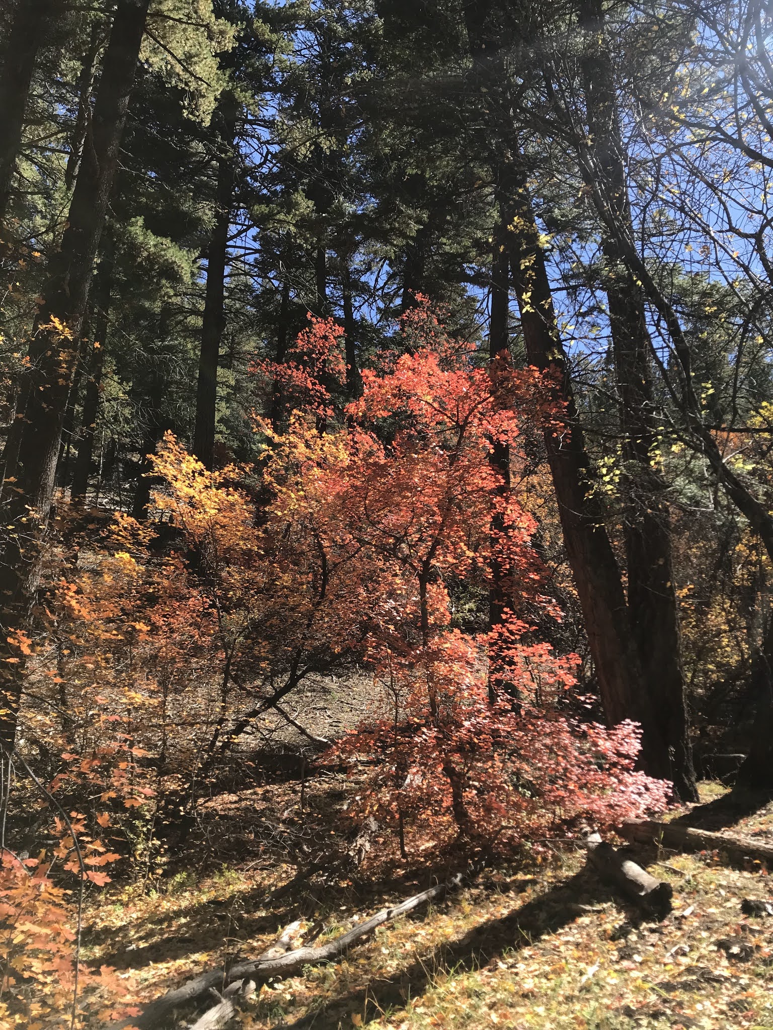
 In the first meadow there were aspens and maples in brilliant color. We had seen a few on our drive back from Ruidoso last weekend, but I would say we were still within peak week, which arrived fairly late this year. On down the canyon there was just more and more color with the maples, in red, yellow and orange some  intensely back lit by the sun, especially thick on the western slopes.


Rising above the deciduous trees were many  truly tall and wide firs and ponderosa pines.  At times their enormous fallen comrades blocked our way as we walked. There was an old barbed wire and metal post fence that had been knocked down by deadfall in enough places to step over down to negotiate early on, but after that there was a mostly obvious trail to follow all the way down to  FR 162. Some of the trail we were following was kept intact by wildlife, but it had at  one time been a human engineered one with sawn logs in  several places and oddly enough even a small bridge ( what it was  built over I don't know, as there was not a lick of water in the canyon).


Down and down we went with the trail getting steeper and steeper as we did. In all the drop was probably close to 800 feet with the total round trip distance of our hike around 2.6 miles. My goal was to make it  to La Luz Canyon and FR 162 , which  we did. On the way back I had had the notion of using  a long abandoned road on the east side of the canyon to loop back around to our parking area. We had seen the both ends of the road on our walk in, but on the way out it just seemed sun drenched and an unattractive alternative. Instead we rested on a huge stump left from logging days before returning exactly the way we came in.
 Chipmunks scurried on downed logs. Escaping the attention of  my Scotties for the most part. Ravens ( or crows?) called among the trees. A few small birds flitted in  branches too quickly to identify them. That was it for wildlife. We thought we should have seen more given the wild and secretive nature of this canyon. Several years ago I had given thought to do Devils Canyon, just to the east of where we hiked, but a wide swath cut through the forest there for power lines put a damper on my plans. I may still go have a look there one day, but the canyon of this delightful day, where the weather was cool enough for long shirt sleeves, but not so cool as  to need a jacket, where the breezes were just enough to send a few autumn leaves tumbling to the trail where they gathered thickly enough for my  short-legged dogs to rustle as they went through, this canyon, with its snags and downed timber, and green bottom land, this canyon which we hiked in perfect peace and solitude  so intense that it gave me a chuckle to think of  crowds descending on the maple rich canyons in the Manzanos so close to Albuquerque. This canyon, just one of many short upper tributaries of  La Luz Canyon was a remedy and more than enough for us.


 A forest spirit


Labels: ,

Wednesday, October 20, 2021

Capitan Mountains - South Base Trail ( FT 57), Lincoln National Forest

South Base Trail (FT 57) cairn is visible near my dog


When things go wrong you learn about yourself. I guess that's obvious to most people with any sense. It's more complicated though, because of our tendency to forget.

 We were staying at a Vrbo house in Ruidoso. For our first hike I had my mind set on something in the Capitan Mountains. I like the Capitans in theory. They are just out of range for day hikes for me so they remain remote and mysterious in my mind. However,  they've got a lot of problems which may be strong secondary reason why I've only hiked there once before. The roads by all reports are not good. The trails, if anything, given the various descriptions I've read in my research, are worse. It also doesn't help that this once pristine forested range that rises very steeply to over 10,000 feet has been burnt over extensively in the years that I've lived here. I bought the Capitan Wilderness Map with high hopes in the late 1990's. On my way to fishing  at  Bonito Creek in the summer of 2004 those hopes were dashed as I watched the plume of gray and white smoke rise from the 67,000 acre Peppin Fire which incinerated  much of the top  and upper flanks of the  main mountain.

 After my one and only experience in the Capitans in 2015 ( a nice hike along the crest even if it was on a road for the most part ), I have been doing a lot of research into the trail conditions in the  Capitans and  I have come to the conclusion  after perusing all the first hand information that is out there online, that the trail system, which consisted of two "base" trails on the north and south sides with many connectors leading steeply up to the ridgeline, is kaput. Damage from the aforementioned Peppin Fire, lack of any maintenance, interest or use led me to think of off trail alternatives.  I had been holding out hope for  Copeland Canyon which  miraculously had escaped serious damage in the Peppin Fire when the Pine Lodge Fire burned the area in 2019.

 So I switched my searching for  a trip to West Mountain. Lower down, smaller, and without a wilderness area,  it appears to have suffered little fire damage and has at least one canyon that is as striking as anything in the large mass of the main mountain to the east. That canyon, Encinoso by name, has practical access blocked by private property at its lower end. There is a road that can be driven to the top of West Mountain ( FR 401 or West Mountain Rd. ),  where one could then walk down the canyon, but the problem is not knowing the true nature of the road until you try it. Although it looks okay on Google Earth, my wife is highly averse to steep, narrow and winding mountain roads in crappy condition, and to tell you the truth after my most recent experience with  FR 330 in the San Mateos, right now so am I.

 Perhaps the road is fine. If you've driven it  let me know what you think. For safety, time and to avoid emotional distress, I quickly scoped out  the South Base Trail ( FT 57 ) as an alternative. Research was brief and mainly consisted of  how to get to the trail head. Mistake. We found the trail head with no problem, other than the rough conditions on FR 338. 

Newer " trail " sign
Older " trail " sign

The problem was, there was no trail. We headed off in the cool morning  pacing through the low growing oak and grass initially aided by some cairns, but these were few and far between and really didn't give one the feel of the actual trajectory of the trail. 

By the time we were about to enter the forested section, we hadn't seen one in awhile, but we plunged into the  low growing piñons and junipers anyway. Through here any vaguely cleared looking area seemed to be  calling to us as  a trail, but we never found it or maybe we did but didn't know it. I turned on the tracker on my On-X app. but I couldn't see the map for the area ( despite the fact that I had  service ). At the  same time I got the notion that we had wandered too high up on the hillside and that the trail was actually lower down. Another mistake that maybe could have been avoided had I studied my paper map and Google Earth even a tiny bit more. We passed through some lovely clearings and then hooked up with a trail that took us down to the Bill's Canyon sign back on FR 338. Only I didn't know at the time. I still at least half-way believed that road was the trail ( once again an easily avoidable mistake had I studied the map a little bit more ). I did get out the Capitan Mountains Wilderness map at this juncture, but since I didn't really know where I was, it led us to wander, what I found out later out was private property for awhile ( my sincerest apologies to the owners).  It seems the fence line that we were following ran through the middle of the property, and when I finally encountered a no trespassing sign, well away from the fence, I was bewildered enough to curse my luck and change my course.

 We headed up high towards the arms reaching down from mountains with their rock glaciers of pale gray flanking the short canyons in between. 

Capitan Mountains

I had caught a glimpse of the rock formations in Buck Canyon, and thought that a worthy destination, but it was too late. The climbing was  tough on the rocks and boulders and we gave up and ate our lunch in the shade of the piñons, junipers and little ponderosas. We never intersected the trail again, although as it turns out we weren't far from it. Afterwards we headed west and then southwest trying to pick the path of least resistance ( fewest rocks) and ended up sadly, what I knew absolutely this time, back at the road, which we hiked in the heat  back to our 4Runner parked near Uranium Canyon ( there is also Thorium Canyon out here which led me to think perhaps these place names were part of some  ploy  back in the days of the uranium prospecting craze of the 1950's, if you know any more about it let me know). I felt defeated like I had lost something that would be hard to find again. Like a child I immediately and foolishly wanted go right back out there and show that  trail who's boss. And I probably would've if I had been alone.

What I learned:  When I'm not hiking regularly my skills and instincts get a little rusty so I shouldn't take it for granted that my extensive experience will always win the day. A happy outing ( for me at least, my wife didn't seem to mind much as she enjoyed the fall weather, and the fact  that our dogs stuck close with us in the close quarters of the forested sections instead of tearing down the trail as is their wont) requires due diligence on the research in seldom visited ranges like the Capitans or . . . a  more flexible attitude. I'm not really good at stopping to smell the roses or making lemonade when I get lemons, but those cliches are still good ideas to keep in the back of one's mind. It does really annoy me to look for trails that aren't even there through large sections. Why pretend Forest Service? When I get on someone else's train I want there to be some tracks otherwise I'm better off doing what I do most of and best nowadays - devising my own hike by picking a destination that looks interesting to me and figuring out the best way with roads, trails or cross country walking  to get there. Otherwise, my investment tends towards the casual which is not the best recipe for success.

 The next day we went out to look for the Tate Petroglyph site with the information I'd gotten from a friend. Another beautiful ( if a bit warm for October) fall day. We used a single waypoint and we got to it hiking in similar terrain as the previous day. Couldn't really find the petroglyphs though. Oh, I did find a half dozen small ones of little consequence, but not any of the spectacular ones I've seen in photos. I also  found a rattler who was very much awake in one of recesses of the bouldery cliff face I was poking around. I had done my best with my limited time and information, and I mostly succeeded in not letting a second failure ( of sorts ) get to me.

Somewhere near the Tate Site

 When I got back home on Sunday ( 10/17/2021 ) I immediately scoped out  on Google Earth and my map software trail less hikes that caught my eye in the southeast corner of the Capitans and thought to myself " that's more like it."

Labels: , , ,

Thursday, October 7, 2021

Lincoln National Forest - McAfee Canyon


The entrance to McAfee Canyon is very slightly southwest  of and across the highway (County Road E- 12, also known as FR 537 and the Sacramento River Road) from the pull-out parking for the Corral Canyon Trail. There is level, gravel area across from the mouth with room for a couple of vehicles to park. After parking, and figuring out for sure which canyon we wanted, we hiked across the Sacramento "River" and up and onto the dirt cattle trail cut in the green turf of weeds, wildflowers, and grass. The "trail" doesn't last for long, but it's no matter, the valley is easy, if somewhat lumpy walking without one. Here and there are narrow passages between the forested hillsides with a channel for stream flow( but no water) where there were cropped older spruces, but also a conifer nursery of sorts lining the banks with young spruces and firs.

 Mostly, however it was wide, without an obvious stream course and open to the sun as is typical of many, many named and anonymous canyons in the Sacramentos.  Thistle was blooming, and butterflies  were making their way from purple flower to purple flower. Beware of the stinging leaves. You can even feel it through your clothes. Our dogs did their best to avoid contact with them as we marched ever upward.

Chipmunks and squirrels scrambled and squeaked in the many very old slash piles ( perhaps even left from the railroad days?). Flashes of blue descending through pines was a Stellar's jay, ravens beat their wings among the trees, and a few juncos bounced from branch to branch. We heard an elk bugling, but never saw any larger animals, including cows ( for which I was grateful as I had two cattle-hating Scotties with me). 

 An old railroad grade, now given the road ( or trail ) number 5015 crosses the canyon about half-way up. We used it for a little ways to bypass a lengthy area of downfall on the way up and on the way back.

 The nicest thing about this valley hike that is so similar to others around the forest is that it ends at the Sacramento Rim. There weren't many views where we emerged, but a short walk north led to and open area with long distance scenery all the way out to the white sands and beyond.  

We tried the south branch of the railroad grade  when we were returning, but after a short distance realize it was taking us up the mountain and not likely return to the canyon. So, we cut back down a ravine, on the way walking past a huge sawn log that must have come loose way back when.

  The shade was plentiful on this fall day and it didn't get above 65 degrees, so all in all it was hike that was just what we were looking for: an escape from the lingering heat in the desert. The colors of the aspens, maples and oaks had yet to really develop, and it may be that it won't be  great color year due to all the recent moisture, but that's all right.

Labels: , ,