Thursday, June 7, 2018

Rain Creek- Gila Wilderness
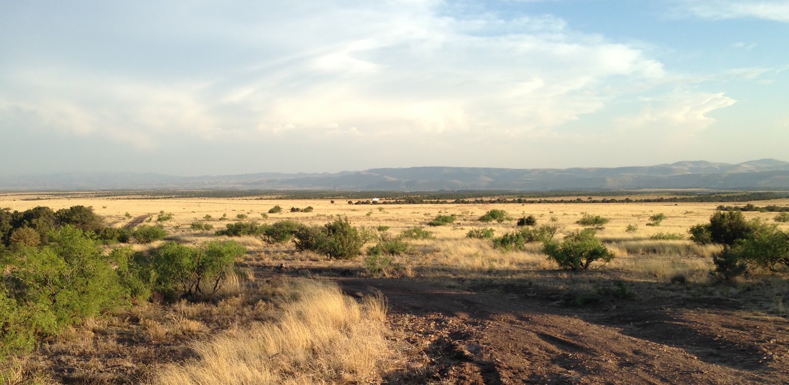


Rain Creek Mesa


   My wife and I visited Rain Creek quite a few years ago. We were staying at the Bear Mountain Lodge in Silver City and ventured out for a day hike. I also had the idea of doing a little fishing. Well, we hiked down to the creek from Rain Mesa. The stream had some water at the crossing, but I didn't see any fish. We continued on FT 189 up the east side of the canyon where it treacherously and precipitously  winds up to the top of the ridge between Rain Creek and West Fork Mogollon Creek. Where it leveled off somewhere up high, but before we could look down into the West Fork, we decided to call it day. Back down at the creek, I tried a little fishing. There were no fish. I hiked a ways up stream, and instead of finding fish, the water went underground. The creek looked just like a cobblestone road. Now I know, if I had continued on for a while longer I would have found both.
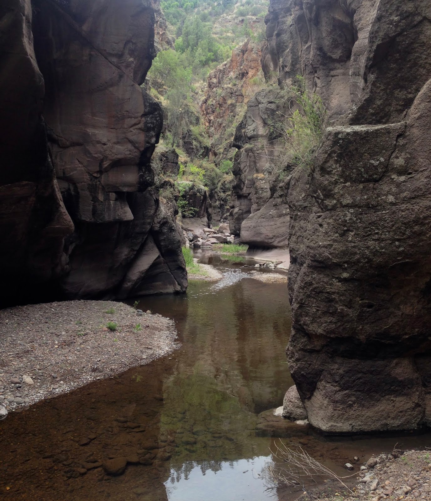
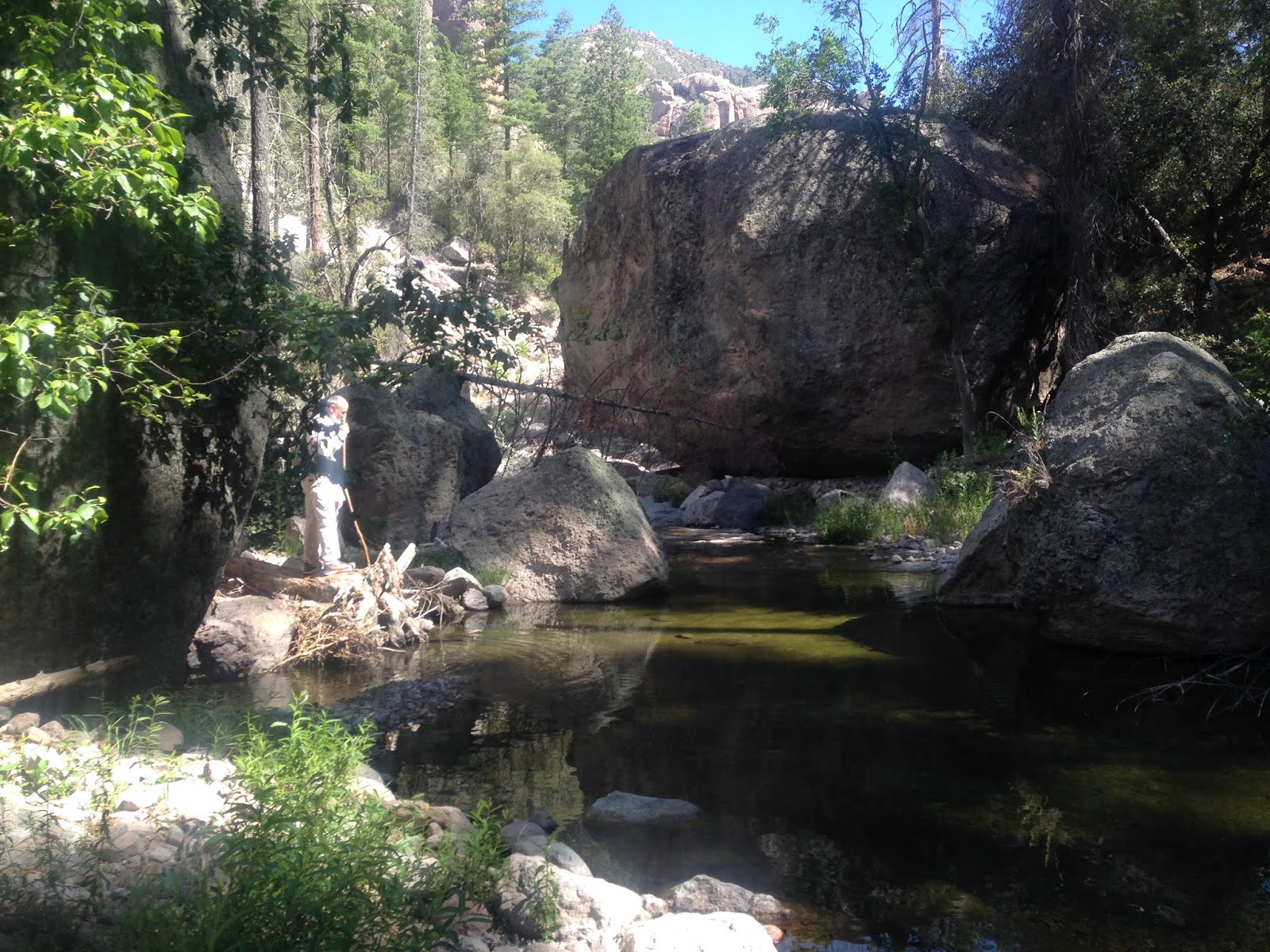
   I returned to Rain Creek on Tuesday, this time with friend Doug Scott. Doug, as almost always, was stalking  a waterfall, this one, which looks like a spectacular 200 footer on Google Earth,  is way up high on the eastern fork of Rain Creek, six and a half miles from the trailhead.  We had spent the night at Los Olmos in Glenwood  and drove off around 6:30.We started our hike, after a little mix-up with the roads getting to the trailhead, at around 7:50. It was already feeling warm. Down in the canyon it was only bit cooler. Where the official trail switchbacks to south on the east side of the creek there is a sign, that's where we took off onto the abandoned, but still usable Rain Creek Divide Trail which heads north. We followed the trail, then at the first creek crossing, we began using the creek itself for a stretch. It was dry where we hit it, and for a ways upstream, but soon we found water, and with it, fish. Dark forms in the dozens were wriggling about in every pool, which were anywhere from 6 inches to 3 feet deep, and they scarcely acknowledged us as we passed by. The creek sides were green with alder, willow and boxelder and for the second time in less than week I was just enjoying being in place that wasn't dry and hot.
Rain Creek

Several trout visible in this photo

At times we used the trail, which climbed ridiculously high above the creek.  And when we couldn't find it on the other side we'd try the creek bed again for awhile, sloshing through the waters filled with hundreds of unwary trout, and then crawling, climbing, going over, under and through boulders and flood lain debris.


Through one stretch, the boulders went from big to bigger to biggest with king of them being close to 100 feet high and at least 100 feet wide. It must have been quite a thing the day that one broke loose and came tumbling down the mountain.


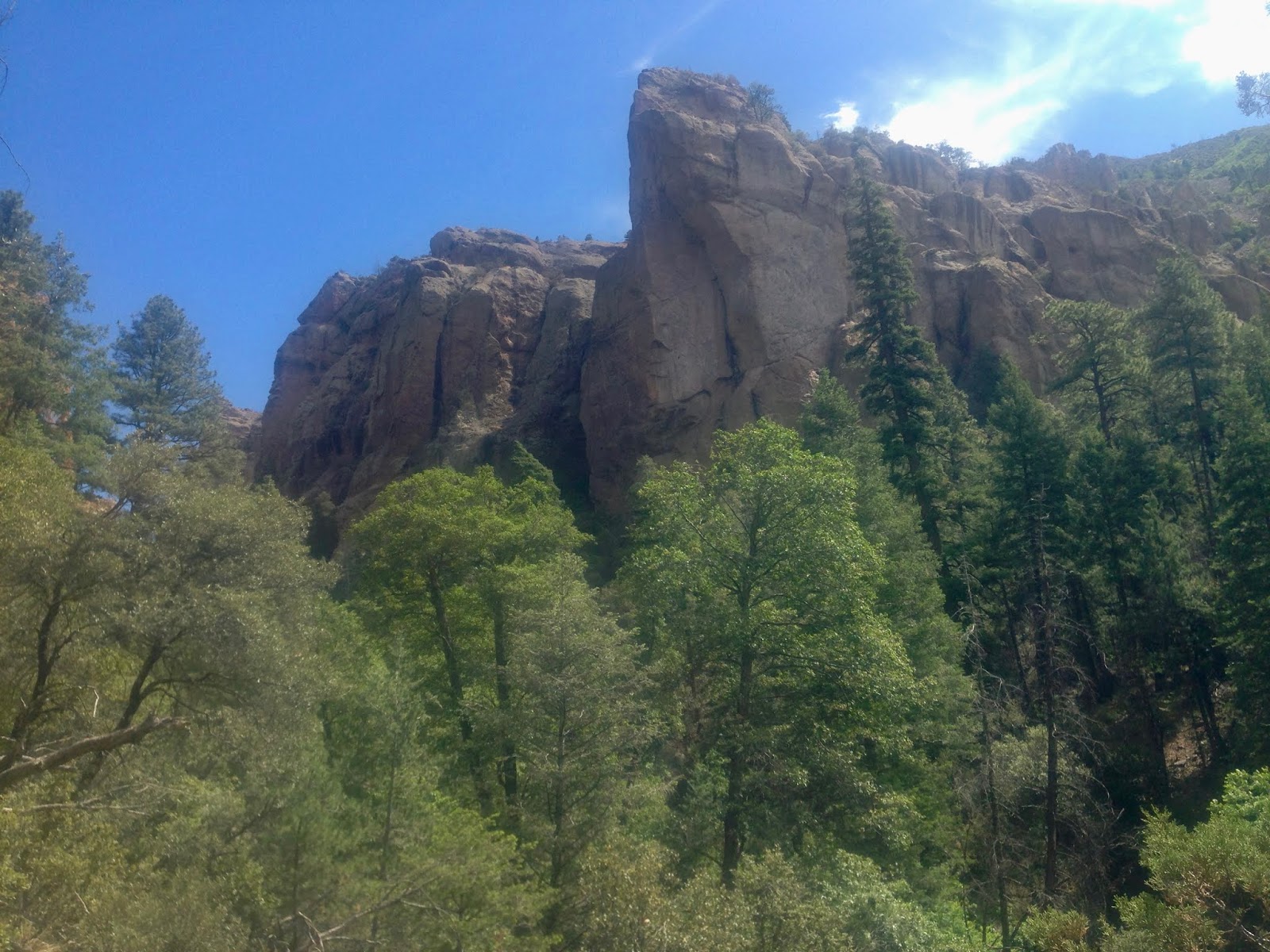
 Up on the west side were enormous hoodoos, towers and cliffs of pink conglomerate. A natural arch was up there too. Soon, the orange cliffs, full of alcoves and caves only for eagles, rose up 1,000 feet on both sides of the canyon.


We were high up on the west side on the trail which had become just a narrow dirt tread more suitable for deer than the tired old legs of two adventurers past the half-century mark and had passed the steep slashes in 10,658 foot Sacaton Mountain that are the west and middle forks when we decided to head down and continue up the east fork, which is the most sizable and more like a continuation of the main creek. Now we were just climbing from pool to pool, each one had me thinking it surely must be the last one to hold trout and then being proven wrong each time. Throughout the day the average size of the fish in the pools seemed to increase the farther up we went, although some who had chosen the wrong pool to hold out the drought in  were surely stranded. I have heard, though not had confirmed, that next door in the West Fork Mogollon, way up high in the inaccessible gorge  carved in bedrock are two foot fish. The best I saw in Rain Creek in this low water year was probably close to 12 inches, but the whole environment seems fertile enough to grow larger fish during wet times. We finally reached a wall of rock trickling cold precious flow on its face that would have been a beautiful 25 foot white waterfall had we had something even vaguely resembling average precipitation this year.
 I was done climbing. I pulled out my oldest and cheapest rod ( a 7 foot switchable fly/spinner bought at Academy in Houston more than 20 years ago) and my Shakespeare 1094 reel. Doug went up high on first one side, before switching to the other in search of his waterfall. I wished him well and then calmly untangled my line. Then, because we had been happily observing the trout taking flies on the surface all day, I attached the smallest dry fly ( a blue dun looking thing) and was in business. All I'll say about the fishing in these upper reaches is that it was hilariously easy. You can catch as many as you want. The only problem is getting the bigger fish to come to your fly before one of the many four or five inchers greedily grabs it. One method that seemed  to work was to run or skim the fly away from them which may trigger a greed reflex ( Rex Johnson Jr. observed this as well in his seminal book Fly Fishing in Southern New Mexico ). It was fun. They definitely look like a mix as far as phenotype, even high up on the forks, similar to wild fish I've caught in other parts of the Gila. Doug remarked that I had caught fish in all three of the upper forks. I continued to fish as we scrambled back down. The fish were more wary lower down, but still willing at least to approach the fly even while I stood in plain view at times.


 I would have liked to fish more, but now we were working on getting back before dark. We rested at a pool below a waterfall on the west fork, where I caught my largest fish (10-11 inches). I had forgotten my lunch and had only trail mix, no worries though, I was running on wilderness power at this point.

We stayed in the stream for awhile. Doug was wanting to avoid the lush poison ivy that grew along the trail, and I wanted to avoid all the climbing, but eventually we got back on it to put the miles away. A healthy looking black bear crossed in front of us and went up the hill. We crossed the stream over and over, each time we were on the east side speculating if we were on final stretch to FT 189 and then the last leg of our exit. We stopped at the last creek crossing. I drank what I think was my seventh or eighth liter of water of the day. My feet were completely marinated and tenderized. I had soaked my shirt earlier to stay cool, but really the 600 foot, less than 2 mile climb out, now on the good, maintained trail was not hot (it was now past seven ) and really a piece of cake as we took a steady, but relaxed paced and got back to the vehicles in reasonably good shape.


Doug did not find his waterfall, the terrain perhaps too treacherous up above, and the stamina in too short supply, but it didn't dampen his enthusiasm for the place or the trip.   Our 12 hour day in the Gila Wilderness was done. As I drove home in the darkness, my brain kept filling in pines, firs and cliffs on the sides of the highway instead of desert flatlands I knew were there.

Labels: , , , , ,

Sunday, June 3, 2018

Sapillo Box- Gila Wilderness


Propane canister and sandal in a massive pile of flood debris

Sycamore trunk
  I've fished the 3 or 4 miles of the Sapillo downstream from the NM 15 bridge many times, but I've always wanted to get way down into the deepest part of the box to see what lurks there. I finally decided to just go for it, after years of hemming and hawing( and also trying unsuccessfully to interest others in going down with me), on my own. Because of our extended drought and the resulting lower water levels, I figured this would be good time for negotiating the narrow passage, which I've heard requires swimming in a couple of spots. I also reasoned the heat of the last day of May would have me welcoming a dip in the creek.
 All good. What is problematic about visiting the box is there is no good way to get there. Following the stream down from the bridge requires over 6 miles of  hiking, which after the first mile or so is without a trail. And that just gets you to the beginning of narrowest section which continues for nearly to two miles downstream. So it's going be a slow( because of the many water crossings) hike in the range of 12-16 miles  roundtrip. Coming up from the confluence with the Gila River requires a similar investment in time and mileage because one has to come down 6 miles  on the Sheep Corral trail just to get to the Sapillo. That route is best done as a backpack, especially if you are planning on going out the way you came. Staying for few days will also help you forget the tortuous, rough and (need I say it) slow drive on FR 282 just to get to the Sheep Corral trailhead.
 There's also the option of hiking the Spring Canyon Trail, which winds along ridges and canyons high, hot and dry on the north side of the creek and then seeing if  you can find a side drainage or ridge that will bring you down safely to the creek bottom when you're about 4 miles in. Not the best, but a possible option in cooler weather.
 My choice was to drive in on FR 579 on Wildhorse Mesa on the opposite side of the Sapillo. This road becomes marginal after the first cattle guard. High clearance is mandatory and even though it was dry on Thursday, it was easy to see that this route becomes a muddy mess after rains  or snow.
 My original plan was to park  about midway to the road's end and then make my way straight  north to a relatively gentle ridge that would take me down to the creek without too much adventure. But after I parked and began walking, I didn't like the feel of what I was doing. I couldn't see anything but the piñons and junipers right in front of me. I can walk a straight line, but without any landmarks, I felt like I was hiking blind which, when you are without any kind of trail, feels wrong to me.
 Instead I got back in the car drove bit further on until I parked just before a really rough patch. From there I began walking on the road( which actually improved and could've been driven) as it turned to the north and followed along the edge of the mesa  600 feet above Trout Creek. When the road ended shortly after a fenced area with a wildlife drinker, I followed the cowpath through the stumps of what were once very impressive juniper trees. When the path ended I continued hiking out onto a very narrow ridge. Far below me was the deep green of the many deciduous trees( boxelder, sycamore, cottonwood, willow, and walnut) of both Trout Creek and Sapillo. Rusty red cliffs terminated  the dusty dry mesa opposite me.


 Now I had a decision. To go down or not to go down.  I knew the climb out was going to be tough, really tough if the sun ever decided to come from behind a fortuitous blanket of clouds. I banked that it wouldn't  and headed down: steep, steeper and steepest 'til I was safely at the bottom right at the confluence of the two creeks.
Confluence of Sapillo and Trout Creeks

 I was happy to be in the shady canyon, green with wild mint and grasses growing on its banks. I headed downstream with a heart lightened of its load of anxiety.  I walked along the creekside, or rock-hopped in the creek itself, which was understandably low but its flowing waters still a joy to behold. Trout and suckers ( and maybe some chubs and dace) scurried  about in the pools at my approach. I had made the decision not to fish and left the fly rod back at the truck. It was probably for the best, but I felt a little tinge of regret. It didn't last long as the scene shifted from pretty to something more akin to awe inspiring as the canyon narrowed and the basalt cliffs rose up hundreds of feet above my head.

 Soon I came to a dripping and trickling 30 foot waterfall on the north side that I believe is mouth of Lower Spring Canyon. I began to have to wade more, but it was only thigh high waters at most. The canyon alternated now between open pockets with trees and grapevine, and narrow passages through solid rock strewn with enormous boulders.


 I ate my lunch right at noon. My turn-around time was going to be 1:15. At 12:45 I arrived at the deepest pool yet. One that couldn't  be circumvented unlike several in the wider parts of the canyon. The passage curved through the gray rock for perhaps a hundred feet. I put my pack down and waded out once,  then twice. It was going to be over my head. I tried to the left and then to the right, and then right on the gravel plume dead center. It didn't matter. It was still going to be over my head. I scooped up some air with my rubber backpack, which I had brought for this occasion, and floated out to the middle once and then twice. Its qualities as floatation device were not impressive. Still I was contemplating putting  my regular backpack inside of it and  continuing on, when I discovered its narrowness would necessitate emptying everything out of the regular backpack and then putting the contents( and the dry backpack) inside. I should have probably checked that out back at home.


       I can swim, although I never have with shoes and clothes on.  It would be short swim to shallow water flowing on a gravel bar on the other side. I thought about stripping down and just going for  it with my phone (my camera) around my neck in its waterproof little bag. I knew I had to be close to the 10 foot falls on Sapillo which is also very close to the Cow Creek waterfall- my hoped for destination.
There is something about being alone in wild places sometimes. This sounds strange because I go it alone almost all of the time. In the end, various factors, but mostly just that feeling of vulnerability from being alone that perhaps when I was 20, 30 or even 40 wouldn't have mattered as much to me, meant that I wouldn't swim to get to the other side. Instead I made an easy little climb to a ledge on the north side, snapped a few photos, climbed back down and began my journey back.


 I was happy listening to the bird songs echoing down canyon. I ate my pear.  I was soaked up to my neck. The water had been cold, but  I was rapidly drying in the single digit humidity. Coming out of the deepest part of the box I could feel the heat again. I realized I had been enjoying at least 10 degree temperature difference for the last couple of hours.
 Back at the confluence I re-soaked myself, drank a bottle of water, and refilled my empties with creek water. I headed up Trout Creek trying to enjoy a little more shade before heading up the hillside. Trout Creek which must've been a fishing stream at one time was a bit sad to behold. Though canopied over with riparian trees, it had no flowing water, just boulders and bedrock covered with dried algae and stagnant puddles at the bends.


 I began my ascent up the steep hillside, first in the ponderosa pines and then in the thick grass sparsely wooded with dwarf scrub oaks and junipers. It was harder and took longer than I expected. Luckily the sun did not come out, but it was still quite hot. If it had, it would've been very, very bad.  If you are considering this trip in the warmer months, I would recommend a shuttle hike going down from the mesa and walking out upstream to the NM 15 crossing.
 It took me nearly twice as long to get back to my vehicle as the hike down to the creek, most of that time spent resting between pitches on the steep side of the mesa.  On top, the flat terrain was a welcome relief. I saw a group of deer just like I had in the morning and soon I was driving back right on the schedule that I planned.

Labels: , , ,