Wednesday, October 30, 2019

Fillmore Canyon Trail 2019 - Organ Mountains - Desert Peaks National Monument


I did a second LCPS staff and family wellness hike to Fillmore Canyon. Not much to say, except it was a beautiful, cloudless fall day, and our group of eight had a great time. A bonus was seeing a couple of deer right along the trail on the return trip. I used to see deer in the Organs all the time, but it had been awhile. Now I'm hoping I'll start seeing them more frequently. We turned around at the same spot as last time: under some big pines right where the upper reach of Fillmore meets the larger canyon that heads through the Narrows.
 As much I like to always be doing hikes in new places, it's always nice to take people to a spectacular place that they've never seen.

Labels: , ,

Saturday, October 26, 2019

Elk Canyon ( Forest Trail 253D ) - Lincoln National Forest


 Our second destination of our 4 day weekend camping trip was Elk Canyon, also located in the remote southeast corner of the Sacramento District of the Lincoln National Forest. The previous day we had walked a section of Forest Road 253 ( Lick Ridge Road ) and decided it wouldn't be too bad to use to access our trail, despite  the warnings from Lynn Melton's Sacramento RD website about how abominable this road is.
 Well, we should have remembered that sections of forest and desert roads up on the tops of mesas and ridges throughout New Mexico are always more benign that their traverses through stream valleys and climbing hillsides. FR 253 started off okay, but fairly quickly the ruts, protruding boulders and lingering mud began. This road had the complete spectrum of poor conditions whereas most others we encounter have one or two. The best thing that could be said about it was that it wasn't exceptionally narrow.
 At one point we stopped and long contemplated a particularly bad section of ruts, but then continued on only to encounter an even longer more horrendous set shortly thereafter. We drove up off the road to a level area near a corral and tank. As we considered what to do next, a couple with a  two cute dogs in a high clearance side by side ATV were approaching very slowly and severely off camber down the miserable stretch that had us stopped and wondering what our next move should be. I chatted with them briefly, opening with the comment " this is the worst road in the forest." They could only nod and say" it doesn't get any better."  They also informed us we were very close to our trailhead. We decided to  drive just bit further, following some tire tracks in the grass  on the mercifully flat terrain beside the road, with a very narrow passage between the water tank and the drop-off to the treacherous  road bed below thrown in for good measure. Where the tracks led back onto the road we pulled up a little farther and parked.
 It was only short walk to the turn off for FR 253X, another road that Lynn Melton warns about on her website, although we noticed that, excepting for some easily removable debris, the short section we walked on was much  better than FR 253.

 Okay, enough of all that. The Elk Canyon trail( an old timber road) initially had us climbing but then descended into the valley for some easy walking through park-like stands of well spaced pines.  At our first rest stop, my wife realized she had dropped the printed hiking directions ( from Ms. Melton's website of course).  I backtracked to find them because I remembered there was some maneuvering in the last mile or so. I traveled back a little farther than I thought I would need to, but there they were white on the  greened over roadway.

Eventually the trail climbs on the south side and well above the rocky stream bottom. At about two miles from the trailhead, there was a berm across trail in the direction we were going. We quickly realized the trail was making left turn and now was following a small tributary to the south.
 
Soon afterwards we sat down at a crossing of the dry creek, a nice spot for a rest. After starting again we  came to a junction in the trail, where we made another hard left, which meant for short ways the trail was actually going in the opposite direction from the first two miles of the hike. It was more narrow now as well and we were in a steady climb to reach the ridge top as the trail  curved back around and brought us to the upper trailhead. It had been a bit warm for a while, and after turning around, we rested again to help cool our pups off.

 We set a good pace, now going downhill, and after eating our lunch, we made good time back to the trailhead on FR 253X. We noticed on the road walking back to the car that the problem with the most horrendous section FR 253 is that for about 4/10 of a  mile or so, the road is now the stream course for Elk Canyon, with run-off and floods  running through it year after year.  We now made one of the slowest 2 mile drives in the Lincoln back to the Piñon Draw Road ( FR 183). This is a nice hike for cooler months. We ended up hiking about 7 miles roundtrip with the extra road-walking.   There may be( but probably not) better access( as in better road conditions) to the upper trailhead from the upper portion of  FR 183 and ridge top section of FR 253, but that involves a lot more  potentially very slow driving.

Labels: ,

Monday, October 21, 2019

Long Canyon, Lick Ridge Loop ( Forest Trails 9652,9666A ) - Lincoln National Forest


 Over the last 6 or 7 years I've been making an effort to hike  most of the official trails in the Sacramento District of the Lincoln National Forest.  I'm not going for them all. There some that just don't appeal to me and I don't have that obsessive completion complex that motivates many hikers. Still, I've done around 60 and probably have a few more that I want to see. It's been fun.
 The four trails out in the Piñon Draw area in the remote southeast corner of the district have been on my radar for years, but they are so far and gone that they are not really convenient for a day hike, if the day includes driving back and forth from Las Cruces.
 On the long weekend, we were camping this year, as we did last year, on a friends property by the Peñasco River near Mayhill.  I figured this as close as we are going to get. It still took 45 minutes to get out to the trailheads we used. The only way to get really close would be to camp in one of the many clearings along the Piñon Draw Road ( FR 183), but as we observed on that first day, they were jammed full  of huge fifth wheels and trailers  and the hopeful hunters who brought them there. As is now well known to us, the population of even the most remote ranching country or forest canyons and ridges of the Lincoln National Forest, increases dramatically once the hunting season begins.
 Just past the largest of clearings, which was almost like little town with hunters and families bustling about, is Forest Road 253( which I'll deal with in another blog). About a 1/2 mile past FR 253 is a worn brown sign for Long Canyon. After crossing the  dry stream bottom, Forest Road 557 was on our left. Call it what you will, "primitive, un-maintained", FR 557 was a bit of an adventure. High clearance is most definitely needed, and if there has been even a meager amount of moisture, four wheel drive will become necessary. Narrow, bumpy, occasionally muddy, with many crossings of canyon bottom, the 3-4 mile drive took around twenty minutes. Funny thing is, as bad as it was, we didn't know how good we had it until we drove on FR 253 the next day.
 We parked just across from a final  crossing  with the trailhead signs visible beyond. Some black cows and calves were milling about a small circular drinking trough. Nearby were stacks of guided missile canisters,  I'm guessing that were used to store water or molasses  for the cattle.


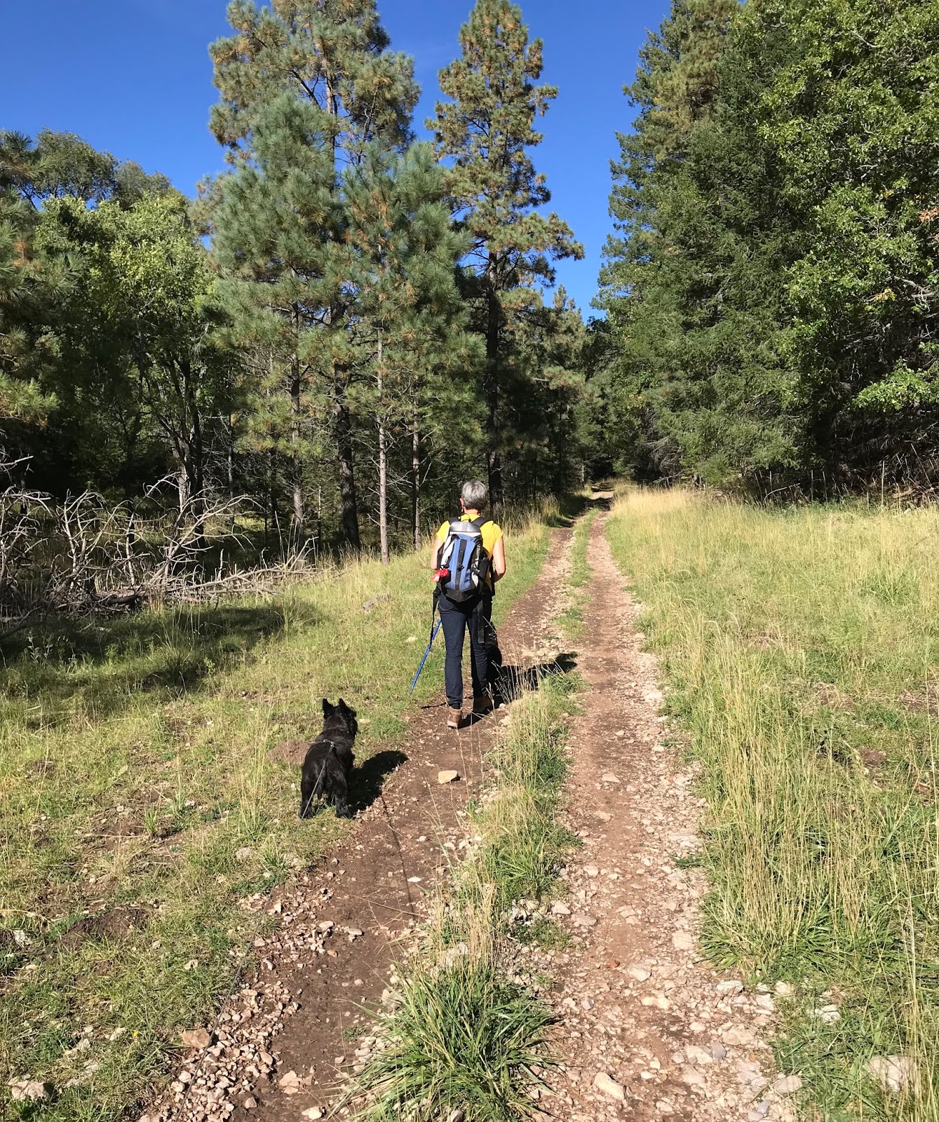
We walked the last bit of road to the trailhead that serves for both the Lick Ridge Trail ( FT 9666A) and the  Long Canyon Trail ( FT 9652 ). We started up Long Canyon on the right. The "trail" is an old logging road, of course, now greened over with clover, and grass, that follows along and frequently crossed the narrow streambed that cuts through thick layers of gray and tan limestone. Well shaded by pines and oaks it's a pleasant, if unremarkable forest walk. Its best qualities are the easy walking and the complete solitude.

 
We were occasionally hearing some elk bugling, and eventually were getting so close that I knew we were going to either see a bull elk or some hunters in pursuit. Turns out it was the latter.  I saw them on the canyon side above us at about the same the saw us.  I don't  know if I ruined their morning, now that they realized their calling was in vain. Oh well, we kept on walking.
Eventually the trail begins climbing more earnestly. White and douglas firs appear on the hillsides,  while on the ground the road begins to disappear. We stuck with the canyon course until we were on top  of the sunny ridge with scattered pines and a thick undergrowth of brushy oaks. At this point there was no trail at all but I knew we were very close to meeting up with FR 253. We ran into the remains of a wooden frame work (for a deer blind?) now mostly concealed in the low growing oak and then directly ahead a few hundred feet or so was the road. This upper trailhead is unsigned, which is one of  several reasons I strongly recommend doing this hike from the lower. We turned to our left and now began our 1.2 mile walk along the clay and gravel forest road on top of Lick Ridge.
 It was a bit warm at the noon hour and there was little shade except for the occasional roadside juniper, so the walk, although mostly level, seemed long. My wife was keeping track with her I-watch and precisely at the appointed mileage appeared the signed trailhead for the Lick Ridge Trail. Despite having the marvelous, sturdy metal signage that was installed all over the Lincoln a few years back, there has been no effort to actually cut a trail of any kind on behind it. We had walked only short ways when we saw a small carsonite sign pointing to our right and an old road going straight ahead. We consulted Lynn Melton's trail description from her Sacramento Ranger District Trails website. We still weren't too sure and began to walk a bit on the road. That felt wrong to me, so  I veered everyone back to right and we quickly encountered the first of many pink ribbons that I had strong feeling were indicating the route of FT 9666A. They led us to a tributary watercourse that started very narrowly and steeply but then expanded to a size where some remnants of  an old roadway came and went. This little canyon was very sweet to me. The highlight here was a clearing with many bigtooth maples along its edges, and tall conifers rising above.  Unfortunately they were yet to transform to blazing red, pink, and yellow ( even though it was a week later) as the ones we had encountered last year had done. Aah, such are the vagaries of pursuing fall color in southern New Mexico

We ate our late lunch in a shady spot nearby.
The canyon leveled out beyond and followed a more obvious old two track for awhile. We had to give a wide berth to that same group of black cows who were now standing in our path and acting a bit ornery to boot ( our dogs and the half-wild cattle of Lincoln seem to have mutual  hostility, I'm not sure why). We stayed straight with the canyon bottom when a well traveled road appeared on our right and were soon back at the trailhead finishing our little 5 mile loop.

Labels: ,

Wednesday, October 9, 2019

Old Cloudcroft HIghway, Toboggan Trail Loop ( Forest Trails 5002.5003,5004)- Lincoln National Forest


The problem with the Old Cloudcroft Highway Trail  is that it runs too close to the present day Cloudcroft Highway ( US 82 ). The noise level even on Sunday afternoon was more than a little distracting on an otherwise lovely walk along lower Bailey Canyon.
 I had wanted to get in a forest hike before the weekend was over, so I devised this loop on some of the closest ( to Las Cruces) real forest trails I could. So even though we got  a late ( we didn't leave the house until around 12:30 ), the shorter drive meant we had plenty of time to finish this 5 mile loop. Despite the highway noise at the beginning and ending of our walk, I was still very glad to  have done  this hike, where despite being so close to ( and a little bit in) Cloudcroft, we did not see a single other hiker the entire time.
We parked at the  Bailey Canyon trailhead walked down the road and picked up FT 5004 which quickly makes long, kind of creepy passage, underneath the road through a narrow, low ceilinged (dark) tunnel.  Emerging on the other side we followed the two track that runs along the grassy canyon bottom. I'm not sure why there was so much traffic on US 82 at around 2:00 PM on a random Sunday afternoon, but I was glad when after  a little ways past the first trail intersection, FT 5002 angled southeast into the densely forested tributary Mexican Canyon and the noise subsided.

 This was the nicest part of our trip. A shady and gradual climb with abundant big tooth maples on both sides of the trail, this section should be absolutely spectacular when the peak of fall color kicks in, in about a week or so. My wife called this part an " amble."  After crossing Mexican Canyon, the climbing became more earnest and then the we walked out into the bright ( and warm) afternoon sun. The maples and douglas firs were gone, now replaced by scrubby chokecherry and dry slope shrubs. Our black dogs were hot and so were we, but we climbed on, past the crumbling limestone on the trailside. Views to the west opened up, but we really weren't in the mood to enjoy them.
 My wife described this section as a " trudge." I don't disagree.

Eventually we were relieved as the trail leveled out ( sort of ), as  I imagine so were the drivers back in the day who realized they were finally in Cloudcroft after the this last  treacherous climb on the narrow road looking several hundred steep feet down into Toboggan Canyon the whole time.
We passed the unsigned intersection with  FT 5001 and then the trail continued to its dead end at inactive gravel and cement operation just off of NM 130. We backtracked a bit and found the abandoned road that went  steeply down into  Toboggan Canyon. There was bit of water in the gravel streambed here on this otherwise completely dry hike. There was was a closed  metal gate  which we were able to slip through  on the side without actually opening it. After passing through we saw there were some no trespassing signs hanging on it, which we had not noticed it at first because the sides with words were facing in on the approach side.  Shortly afterward we went through an open wire gate. Toboggan Canyon Trail ( FT 5003 ) was cool, but had little else to recommend it. It's very steep, and artificially open because of clearing for the powerlines that run through  it. At the intersection we turned and  headed back along  our original canyon where non- native elm trees were  grew along with aspens that seemed so bright and golden with sun shining through them, but were actually quite dull with black spots on many of the leaves.


Walking through the tunnel again, I was thankful the clouds of  insects inside were not mosquitos, because it would have been feast if they were.
 NOTE: The uppermost parts ( less than  1/4 mile on each) of both FT 5002 and FT 5003 are on private property.

Labels: ,

Wednesday, October 2, 2019

South Fork Palomas Creek Slot Canyon - Ladder Ranch


We continued on upstream in South Palomas and quickly ran into some trouble with the mud on one crossing after another.The creek had receded but must have been running high in the past week, wetting the clay which refused to dry out in these shady stretches. In between nearly getting stuck several times we visited a huge stream side boulder that had several petroglyphs on its sides and two shallow grinding mortars on top.
Finally the narrow passage through the big trees ended as the stream valley opened up into a long, wide, weedy meadow. We rolled along the banks and crossed the now dry creek on the way to our next destination: the slot canyon on the north side of South Palomas that I had spied on Google Earth several years ago.
 We stopped at  an old homestead with a pond in front. It was an adobe, but had a  concrete foundation, which to my mind put its origins sometime in the late 19th or early 20th century. The day had warmed up considerably, but it wasn't uncomfortable. Sunshine, blue skies, and low humidity were  still the order of the day.

 We lunched at the mouth of the slot in the shade of scrub oaks and then headed up. At first there were many trees: walnut, live oaks, juniper and box elder pressed against the the walls of conglomerate, but as the canyon  narrowed most of the plant life disappeared.


 We had to scramble up a couple of pinched-in spots with small chockstones. There was a little water at both. Along the way we looked down  a very narrow side canyon on our left. Although I wanted to explore it, it was going to take some real scrambling, that we really didn't have time for.
 After about a half-mile we came to 20 foot water fall that was the end of line. Once again since I was on the clock and the most reasonable option would be to backtrack and go overland along the hillsides to access the upper reaches, I had to leave it, and begin to head back.

 This was a nice little canyon, but I would still like to explore more of it.
 Back at our vehicle, our guide suggested going to  another homestead at the mouth of the South Palomas Box( Hermosa Box) and also visit the boundary of the ranch where an Apache, US Army battle had taken place.
A path out the back of the  cabin led to the lush ( with huge alders) but nearly dry canyon bottom, where I encountered a very healthy ( as in well fed) rattler, who was very polite in providing a very vigorous buzzing when I was four or five feet away.


Afterwards, we headed back down South Palomas, but exited up a side canyon to south, to avoid  dealing with the mud again. Back up on the mesa tops, we stopped for a few photo ops of the vast rangeland with the peaks of the Black Range far in the distance.
We also paused for some bison watching. It occurred to me that it was absolute insanity to bring cattle to the West when there were already millions and millions of meat (as well as hides, furs and more) providing animals already there.
The wind had really picked up in the afternoon, which made the  drive in the the open vehicle, in open country a little loud, and more than a little dusty.

We ended our day almost 9 hours after we started back at ranch headquarters. This one trip had certainly whetted my appetite to return, and I certainly intend on asking for our wonderful guide Robert again.
 NOTE: The Ladder Ranch is private property. Access is only through guided tours. Contact the Sierra Grande Lodge in T or C for more information.

Labels: ,