Withington Wilderness, Forest Trail 37 (Water Canyon)- San Mateo Mountains, Cibola National Forest

 |
| Start of the " trail" |


 |
| I read this sign at the outset. It just didn't sink in. |

 |
| Aspens returning |
Like most human beings at times I crave to visit green, lush places, perhaps with flowing water or a lake or pond. In the heat of summer, of course, I am also wishing for these places to be mercifully cool. The feeling, the need, gets a little desperate after the third week of 100 degree days and four months of severe drought. I rack my brain for someplace to go for a day trip, that isn't too far, and by that I mean less than 3 hours one way, and isn't someplace I've been to over and over, and is high enough, and by that I mean over 8,000 feet at least, to give a little respite from baking in the desert.
I get my mind fixed on two places: Upper Sixmile Canyon, Forest Trail 14 in the Magdalena Mountains or Upper Water Canyon, Forest Trail 37 in the Withington Wilderness of the San Mateo Mountains. I decide that Sixmile may be a bit too far (mistaken thinking as you will see) compared to my other choice and so settle on Water Canyon.
Off I go on Friday, I wanted to get a super-early start but still end up leaving at 8:00. When I'm just a short ways out of Las Cruces, I start crying and thinking " I miss David (Soules) so much." It's the first time I'm going on one my "adventure" hikes to a new destination since he died. It's not so much that I would want him with me, although I was always happy to have him as my companion whenever we could go out together. It may just be I won't have him to talk about it with when it's over and done.
The drive, all the way to the Rosedale Trailhead (FT 92) goes by quickly and I have the now I know to be crazy idea I'll be at my trailhead in two and a half hours ( total time from Las Cruces). In my mind, I picture a few twists and turns from that point, climb around a ridge and badabing badaboom I'm on top of the mountain with just a couple of relatively level miles to go to reach my starting point. Ha!
Perhaps if I actually had really looked at the upper reaches of FR 330 on Google Earth or my Topo maps software, I would have known better and chose differently. Perhaps. The crazy thing is I've actually driven all the way to the top of this mountain on this road before. A few of the more terrifying moments are still clear in my mind even after 15 years, but, I thought, I've done so much driving on so many bad, scary roads since then, maybe it's not as big a deal as I remember it. It is. I was in a pretty good mood until, after cresting the ridge, the reality of how much longer I was going to be driving took hold as I could see miles of the convoluted band of dust stretching out before me and actually descending(!) considerably to cross a gully. Crestfallen. Literally. Nowhere to go but onward as there was most likely no place where I would feel comfortable turning around before getting to the top. What few turnouts there are on this extremely narrow, as in one, less that generous, lane, are not substantial enough for maneuvering, let alone, God forbid, passing, should another vehicle be coming in the opposite direction.
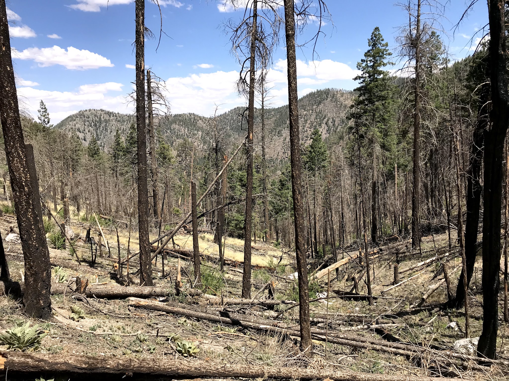
On with the white-knuckling. The road is not ridiculously rough, but is so, so narrow. What's more, since my last time driving it, much of the hillsides it passes through have burned. The firs and pines that once blocked the view of the drop-off of hundreds to as much as a thousand feet, that is just inches away from my drivers side door, are gone. I could only look out to what lay beyond the dry dirt and rocks for the briefest of moments, lest the sickly feeling of levitation and the tingling in my gut and testicles should overwhelm me. It could be a most wonderful scenic drive if the driving and road could let you enjoy it. I thought about stopping the truck to take some pictures, but luckily, the haze from forest fires to the west put out what little enthusiasm I had for the idea. That, and the feeling that vertigo would overwhelm me. Heck, in some spots, I don't think there is enough room to get out of the car without falling off the mountain anyway.
Once on top of the ridge ( at 9500 feet ) I could relax a little. It's really a bittersweet experience to go through. The bitter of the frightening ascent, and the sweetly mellow feeling of aspens, conifers and tiny meadows of thick grass that line what seems like little more than a rugged country lane at the top of the mountain.
 |
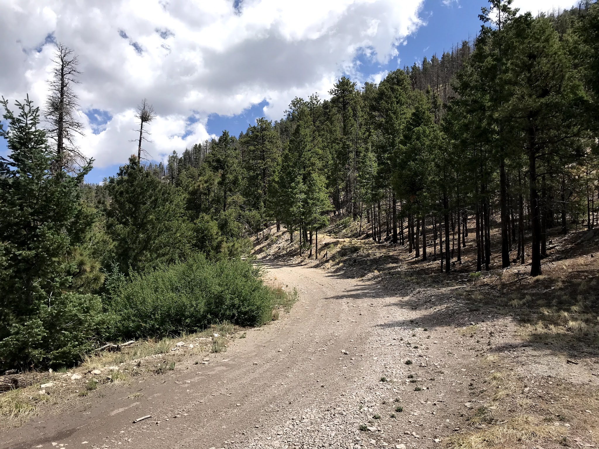
| Forest Road 330 |
 |
| Forest Road 138 |
Traveling on I came to intersection with FR 138. To my left was the short trip to the Grassy Lookout where the road ends. Straight (right) is where I went to continue on to my destination. This was my second and probably my last opportunity to see the lookout. If I had known what lay in store for me, I would've have parked and opted for a pleasant stroll on the road to see it, and let that be my hike and call it a day. I got a little panicky when the road began to descend a little, and also when I saw no signs for the upper end of the Big Rosa Trail (FT 36). I noticed that the Hudson Canyon Road where we nearly got stuck in the snow all those years ago now has "ROAD WASHED OUT" sign. I was looking and looking for my trailhead sign as I drove when I spotted a broken sign just off the road on my right "HINGTON, ERNESS, IBOLA, ATIONAL OREST." or Withington Wilderness Cibola National Forest. There was no trail indicator on either side of the road but there was blaze on a big pine just past the sign, so I figured this must be it.


I check my phone. It's 11:05. Three hours and five minutes of driving and over an hour of it just from Rosedale to here. It was windy and cool when I got out of the truck. I wished I had the nails I used to carry in my backpack to fix the sign, and then I headed down, down, down. I swear as soon as I was just a few feet below the level of the ridgeline, it began to feel warm and humid. At first, there were quite a few newer blazes and the vaguest idea of tread to follow, but then it seemed liked the blaze maker lost interest, perhaps as the downfall increased. The tread was gone. I stayed well above the creek, which has an extremely narrow channel in these upper reaches. I honestly was thinking of abandoning the whole hike as I was now walking through a long area of just snags and downfall and getting hot in the midday sun. Truthfully, I wasn't even sure I was on the trail I wanted, believing for little while that I might mistakenly be on the upper end of the Big Rosa Trail ( FT 36), when I heard something, and that something was water trickling in the stream. Lo and behold Water Canyon has water in it!

Digression: I notch my hiking belt with another Water Canyon. The San Mateo Mountains have at least 2 Water Canyons. One flows northwest off of the range's highpoint West Blue Mountain into West Red Canyon which in turn flows to Cañada Alamosa. This one flows east to Big Rosa Canyon which joins Milligan Gulch. Both Cañada Alamosa and Milligan Gulch are huge desert arroyos hundreds of feet deep where they are crossed by I-25 just a short distance from meeting with the Rio Grande. It can be confusing at times with so many Water Canyons throughout the state. Same goes for Brushy Peaks. Even the Forest Service has the wrong map starting point for this hike on their website, using the Water Canyon in the nearby Magdalena Mountains instead.
Almost exactly a year ago I hiked another Water Canyon over in the White Mountain Wilderness of the Lincoln National Forest. It had water eventually too, but I had to hike much farther downstream to get to it.
Eventually I had to negotiate my way down off the high benches with their yellow grass and a very few live pines to get down to the bottom to walk streamside. It was a little bit of a miracle seeing that stream live however thin the flow was, it was steady and was pretty much present for the rest of the hike. I thought well maybe it's been raining here more recently than I know, or maybe there really is something to this little canyon being named Water Canyon.


Either way I was glad for it and my mood lightened. It was pretty short-lived unfortunately. Walking along the creek, it was endless snags and downfall, if I accidentally brushed against a trunk on either a living or dead tree I got streak of charcoal on my clothes or hands. Just another burn area I'm walking through in a "sky island forest". They're getting harder and harder to avoid. I kept looking for some little idyllic spot for my lunch, which I almost always do find, but no dice here. I had hoped to make it to Leke Spring but when I came to a spot where even though the creek bottom had widened considerably, the downfall and flood debris were so thick and extended so far into my near future of hiking, that I, standing there roasting in the open sun, I, the king of "let's go a little bit farther," said enough is enough, and did so with a conviction that barred perhaps even the slightest tinge of regret.


Uphill was a daytime nightmare. Most of the time I realize how ridiculously steep a trail is when I'm on the descent. This time, the ascent seemed worse than I would have expected. Maybe it was the climbing over endless downfall and failing to get the toe of my boot just high enough, time and again. Or maybe it was the sun at the hottest part of the day when there's barely two living trees in the vicinity of each other to provide even the most meager shade. Or maybe it's just that the trip was turning out to be a total bust. Hell, it wasn't even on my Southern New Mexico bucket list. Why had I come? Why had I continued?
I saw an elk skull and antlers. How had he died? Surely any hunter would've taken these parts as a trophy? I saw chipmunks scurrying about in the dead wood that was everywhere. I saw a small garter snake slide through the sticks. I saw a living bull elk still in his velvet who gave me some long looks before retreating up the hillside. This place is for them, I thought, not for me. I wanted something that I would not get. A forest from a bygone day. A forest of endless acres of green conifers and the blinding white trunks and trembling leaves of aspens, not this burnt, half-dead mess that railed against my inherited aesthetic of a dream forest that shouldn't have existed in the first place if not for interference in its natural cycles.

I took a little comfort in the young firs in the stream bottom, probably the only place they will survive from now on. I doubt they will be returning to the mountainsides, just like so many places I've seen over the past twenty years. Scrub and gambel oak will come in, aspens will return, locust will grow thick and thorny, but the dream forest of conifers will probably not come back, at least not for a long, long time if ever. It's hard to adjust one's mindset. Like I said at the outset, it's only natural to crave certain types of places, but here in the American Southwest, much of it was an illusion. All I can do is look back and be glad to have enjoyed it for a little while. I just wanted a little while longer.

I wanted a little while or a lot longer with my friend David and thoughts of him fill my mind as I rise up the canyon. I'm writing something like a eulogy in my mind as I hike, but it's too personal, too involved in my personal loss, but that's all I've got right now.
I wet my head, hat and shirt in the surprisingly icy cold water that drips from a tiny waterfall created by debris lodged between two boulders. It is very good to cool my head and I laugh at my gratitude. I accidentally leave my reading glasses behind, but only realize it when I am way too far along to go back. Strangely, I enjoy my lunch in some small shade where nearby the water drips off logs, and trickles over bedrock. I look at FS Map thinking I might return home by driving north past Mount Withington and out to FR 549 and FR 52 then circle back around the mountain to get to NM 107.
I am a little confused at several junctions, but I look at my On-X tracking and realized I'm alright. I'm following the water back up anyway, but I surely would hate to get to the top and the road a mile and a half from my car which is where I would be if I accidentally walked up the south headwater branch.
I rest often. I'm exhausted and feelings of paranoia creep in as I think about my friend having a fatal heart attack working in the hot sun on his property on the Peñasco. It seems like it's taking way too long to get back to the top. I probably only ended up hiking a little over two miles downstream. I turned around at 12:40 after only hiking an hour and thirty five minutes, but I'm guessing this return trudge is taking at least twice that long. I see some of the blazes and it gives me hope. I am so tired. I arrive back at the truck at 3:27. Close to correct, my guess about the time.
At first I drive north, but then think better of it. I have no way of no knowing if the other way I've contemplated will be any less slow or frightening. The drive back seems slightly better only because I know what to expect. I look out to the south, once, to see West Blue Mountain seemingly very close. Its presence ( as Rudolfo Anaya talks about the (Pecos) river in Bless Me Ultima ) does not seem in any way benign. As I drive, I'm constantly worried about two things: A vehicle coming the other way, and a flat tire. Well, the way this day was going, one was for sure going to happen. Luckily it was the flat tire. Which I am more emotionally prepared for as I have had to change quite a few flat tires over the last year or so. I may have actually driven on the flat for awhile. Because of the array of lights on my dial that deal with 4 Wheel Drive, I am not sure how quickly I noticed the low tire light. It doesn't really matter, though as there was no place to change a tire until I got to the dispersed camping area at Rosedale. Fix- a -flat maybe in retrospect, but it all worked out. Changing the tire was only a little bit more of pain than usual. And I was only a little more whiny and angry than usual. At least it wasn't hot.
I am happy to arrive home in my oasis in the desert. My wife has made a wonderful meal that I must shower and change before I can enjoy. We discuss how Google Earth should update their photos more often. Tomorrow it will rain.
Labels: hiking, scenic driving
posted by Devon Fletcher at
5:56 PM
3 Comments
![]()
![]()