Tuesday, February 22, 2022

Organ Mountains-Desert Peaks National Monument - Reed Arroyo, Sierra de las Uvas


 Looking north to Peloncillo Peak


 Sierra Alta Ranch house


I've been trying to get into and explore at least part of all the named arroyos ( as well as a few of the more interesting un-named ones) on the northeast side of the Sierra de las Uvas that flow directly to the Rio Grande. Over the years I've visited Horse, Rock, Hersey, Bignell, Angostura and Spring. Reed Arroyo which is in between Bignell and Angostura has been left out till recently because there just isn't any decent access to its middle reaches. Private property appears to block  walking upstream from NM185. From the Barksdale Road it's a long up and down hike in out of many arroyos that are always deeper than they look on Google Earth. There is a questionable road to a couple of cattle tanks that comes from the west which would be the closest of all but it necessitates driving down into and then in and then out of Angostura Arroyo and surely looks like a 4WD adventure that would be more trouble than it's worth.

 I saw a way recently at least to get to the upper end. A very old road, that is no longer on any maps but can be seen on satellite images leaves from County Road E005 was the ticket.

We made the drive out on Sunday (2/20/22). Parking was a little dicey but we found a shoulder wide enough just a  short way past our desired starting point. The massive Sierra Alta was behind us as we started up the road  which was just two cobblestone rows of red rock in the dried grass. 

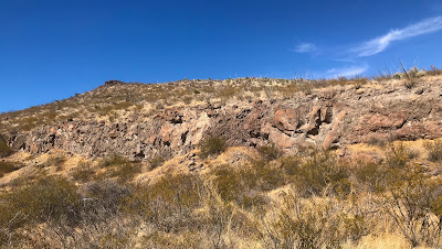
At the top of the hill, we, friends Eric and Edan with daughter Sarah, and my wife and I looked down the steep descent to the upper branches of Reed Arroyo, which were little more than thin ravines of boulders and bedrock at this elevation. Eric went down and then my wife and I went down, but in a little while I was the only one  continuing downstream. We saw a beautiful fox run up the hillside, and hopefully we'll be seeing more as this is the last season of legal trapping on public lands in New Mexico.

  Shaggy junipers grew close to the stream course and at the first juncture of tributaries a truly stout one with impressive girth stood straight as a sentinel. No one else ventured down in the canyon with me, and I waved to Edan up on top and continued. From that point on it was rather un-remarkable. Some low cliffs, undulating bedrock where I could tell water gathered after rain or snow. I passed under one fence and continued on. Flushed out five or six heavy footed javelina but still continued on through a few more bends until I reached a second fence and thought " enough."  I hadn't covered much of Reed Arroyo but now the lower desert was creeping in, the wind was picking up, and as it really was obvious no one was coming down in the canyon, so I felt obligated not to have everyone waiting for me.

 I had all the food and water for my wife and I and hadn't really remembered until that moment. I had tried calling, but there was no service until I got out of the canyon. I muscled up over black rock and through a grove of junipers on a north facing slop.  Broke my hiking pole and found a sotol stalk for a replacement. My wife got through to me on the phone as I reached the top of the hill  and in a few moments I could see them all going over the crest of the ridge following a cow path and not the old road.

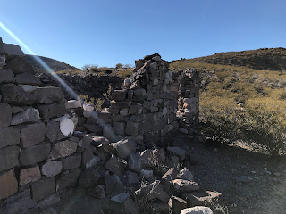
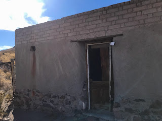
 After getting back to the vehicles, we drove a short ways down to the old Sierra Alta Ranch to turn around. Another tiny house in such a lonely place there on the side of Sierra Alta with an old bed spring for a gate and low fence wrapped tightly around it. Still, to be living there way back when seemed like a wonderful dream of life to me. NOTE: Sierra Alta Ranch house is on private property please be especially respectful of this fascinating place.

Labels: , , ,

Saturday, February 12, 2022

Broad Canyon Wilderness - Hersey Place, Organ Mountains-Desert Peaks National Monument


Broad Canyon on the left


Bell Top Mountain in the distance


I had been wanting to investigate the large Lloyd Well Mesa (my name for this nameless feature) for some time, but when the Broad Canyon Wilderness was established, the desire receded as the ability to drive up close to it vanished when the "road" in there (one of the least savory driving experiences on OMDPNM) was closed. It was only recently that I realized that starting from the Hersey Well on Broad Canyon provided a viable option with a shorter trek. 

Lloyd Well Mesa will have to wait for another day. This past Sunday (2/6/22) we went up onto what I'm calling Hersey Place Mesa which is just to the north of Lloyd Well Mesa across a large tributary canyon of Broad Canyon. I was thinking there could be some archaeological evidence up on top because of its nearness to Broad Canyon and Hersey Spring ( which I'm speculating flowed in pre- historic as well as historic times until  starved of its water by the well).

We followed a cow path up to the top, where there wasn't much to find save a few chunks of obsidian. It was nice and easy to walk around a bit on the flat expanse of gray volcanic ash derived rock paved with rocks of deep rusty brown, but eventually we made our down into the aforementioned side canyon. It  had some nice cliffs and bedrock, but no artifacts of ancient peoples that we could find as we searched the benches along its sides.

Eventually we got to the confluence with Broad Canyon and started heading west toward the cabin ruins of Hersey Place. Just about the time I was thinking that the place where we will probably find  some pottery sherds will be close to the old homestead, Andrea bent down and picked up a good sized piece, and shortly after I found a smaller one.  Perhaps the Herseys though the best place to build  was right where the ancients liked to make their camp too.

The stout stonework of the two room cabin was wonderful, but also almost all that remains, besides a few tin cans. We wondered why there seemed to be no doorway from the one room to the other, but could only speculate that perhaps one was for animals.

 It had been lovely, warm, blue sky day for most of our hike but as we drove home the country to the north of us was overcast, gloomy and looking like rain was real possibility.

Wednesday, February 2, 2022

Doña Ana Mountains - Organ Mountains-Desert Peaks National Monument


Large(for the desert) oak tree


Raindrops, great. Is that snow? No, just tiny little floating pellets of hail, I guess. Aaah, the rocks that stick out of the power line road at the pass. Aaaaand clunk! Every time those metal steps attached to the truck scrape, it's like Dean Martin's joke about cuff links being "curb feelers."  Graffiti is still there. Is that some new stuff on that boulder further along? 
Arrive at my planned parking spot. This gray gravel is tough to walk on or is it through? How is it so deep and so uniform? It's like it was dumped on these roads. I should have driven farther. Cans and bottles, well at least most don't look  that recent. Fewer and fewer people come here since they put in that gate on the good road. First pass-easy. Slippin' and slidin' down the other side. This is a good trail (deer? javelina?) on the other side. I should turn back and look at the shallow alcove with the oak tree in front of it. Okay, okay. No artifacts, nothin,' but it's a neat place and this is a pretty big oak for a desert mountain range.
 Alright, back to the trail, easy up to the second little pass. Windy. Kind of cool. Here we go down. 
Checking out the boulders for petroglyphs. Nothing. Moving from the banks into the ravine itself. Pretty tight in here with its twist and turns. Deciduous bushes on the dirt canyon side with the leaves still yellow. Long seed pods. I am not familiar with whatever is, or I've never really looked closely, or I've been happy to think it's something else (As it turns out it's common name is Tronadora or Trumpet flower or plant, and has spectacular  horn shaped yellow flowers in the warm seasons, which would be quite a sight, and makes me want to return). 
Tecoma Stans var. Angustata

Pushing through catclaw, mesquite, trying to avoid the lechuguilla. That's a scratch. Ow. Ow ow ow ow. Took my eye off the ball for second and get bunch of spines from a purple prickly pear in my leg. Pull the ones in my jeans out. I'll have to wait on the others. OWW! That one went right through my boot. Not going to get it out now. Great. Now it's sunny and hot with this jacket on. Is that a  rock overhang (shelter?) behind those shrubby oaks up there. Let's go see. Up, up. Rustle, clop, clop, clop. Brown tail hanging down with a little white tip. That's a healthy javelina. Snort. Sorry buddy, didn't mean to roust you. No overhang, no shelter. Okay let's stay off the road. It's taking a big U of a turn away from the direction I'm going anyway. 
 Brush was little thick through here

Buzzing of an ATV. Shots way off in the distance. Back on the road now. Stop at a pull-out. Drink. Pee. It's fun to pee right out in the open with the chance of being seen nearly zero. Stuff my jacket in the backpack. A bit of road walking. There's the buzzing red ATV, looks like a kid's toy from here. Go up this  little arroyo, to cut off another wayward turn of the road. I'm so close to catching a view of the Narrow Arch, might as well drift over on this little ridge. There it is. How high is it really? I said 50 feet in the book, but I don't really know. More bottles. More cans.  Too many to even begin to pick up. Michelob Ultra over and over again.  Where vehicles can go, trash follows.What self respecting, littering jackass drinks Michelob Ultra?  Fewer calories are not going to help your fat ass if you drink a hundred of them. 
Looks like a little cave up there. Well, gotta go up. So far this hike has yielded zero evidence of ancient peoples, but I've only picked up a few rocks that aren't pottery, which is better than last time I was out here when I couldn't learn my lesson and got fooled over and over again. Not a cave at all. Another big ocotillo.

The cave that wasn't

Tall ocotillo frequently found against the cliffs

 Bunch of holes in the dirt. Who made 'em? Slippin' and slidin'  back down again. Orange brown leaves in the ravine. That's a big madrone tree. Following a trail barely etched in the hillside looking at one just like it across the way beneath the waxy soft peaks of orange, brown and buff. Gotta get down to the road. Staying in the shade near the gray cliffs, which is a good thing even though it's January 30th. Red ATV buzzing around again. Can he even see me up here?  Stop steps. There's a deer. Buck?  Can't tell from this distance.Get a photo. Here comes another with a little one close behind. Looking at me, looking at them. Quiet. Walk quiet. There they go up  bedrock hillside.  I can hear every one of their steps.

Meringue peaks
                                        
Deer (look for it left of center)

Thinking about which way did I go last time I was out here guiding a group? On top of the saddle  again. Looking around and down for the giant barrel cactus my wife took a picture of me beside many years ago. Not seeing it. Probably has fallen over by now. Pick up the obvious trail on the way back down. More bottles and cans in rills next to this nice little camping site. Shaded now. Back at the blue truck.  4WD handles his gravel fine. Picking up what bottles and cans I can using a planting bag in the back of my truck. It's full and still I get more, but not all. The only way I can even begin to understand this littering, because it's almost entirely beer bottles and cans, is that it's underage drinkers. If it's not then I don't understand it at all. I've been trying to find some kind of significant archaeological site on the BLM (National Monument) lands in the Doña Ana  Mountains for  quite a few years now. There are so many sites in the range, but nothing much to report from the BLM section. I  think I'll leave off exploring these beautiful little peaks, flats and canyons. I'll take people who want to go, but it might be awhile before I'm motivated to come out by myself again. I've been over so much ground here over the years. 
Parked out in the flats. Going over some flat ground while eating my apple. Nothing. Going over some ground where I found a single piece of brown pottery years ago- still, nothing.
Driving home.  Red shotgun shells along the road, that weren't there when I drove in. Picking 'em up putting them in tall drink cup. Too many to fit, but I get 'em all with the second trip.  What happened to the national monument sign? Stolen, I guess. It's been a long time gone. So I guess they've got no plans to put it back up.Take a turn and go down an empty boulevard with  street lights. The plan is to build houses right up to the edge of the public lands so folks can live right next to that stupid golf course ( not that I hate golf, I love it) with  water!!??? in play on every hole


Labels: , , , , , ,