Saturday, July 28, 2018

Aden Lava Flow Wilderness - Gardner Cones, Organ Mountains Desert Peaks National Monument


  I've been intrigued by this little group of volcanic hills in Aden Lava Flow Wilderness Study Area ever since I first saw them on Google Earth. They are not part the Aden Flow and sit atop an older flow, isolated and rising about 100 feet above the flat plains sparsely vegetated with mesquite and creosote.
 One of the hills didn't resemble the many cinder cones in area. It was significantly smaller,  a bit steeper and had a sharp, perfectly circular rim. It didn't resemble the larger shield volcano cone of Aden Crater either. From above it looked more like miniature stratovolcano.
 So off I went. It was cool enough on Friday after heavy overnight rains. Blue sky was woven with thin clouds and the temperature was initially in the upper seventies and never exceeded 86 degrees.
It was a long drive in order to circumvent the JCJ Ranch, which had a sign trumpeting it as the " Home of the Lean Cows." No kidding. There looked like there was very little feed in the harsh desert landscape, where sand, silt and gravel were all that was in between the widely spaced, but happily flowering creosote.

 I parked and began trucking the 1.5 miles to the crater. Lizards constantly scurried and jackrabbits warily moved from hiding place to hiding place. Ocotillo were thick with their green summer leaves.
I had seen a couple of rattlers on the roads while driving, but encountered none while walking.
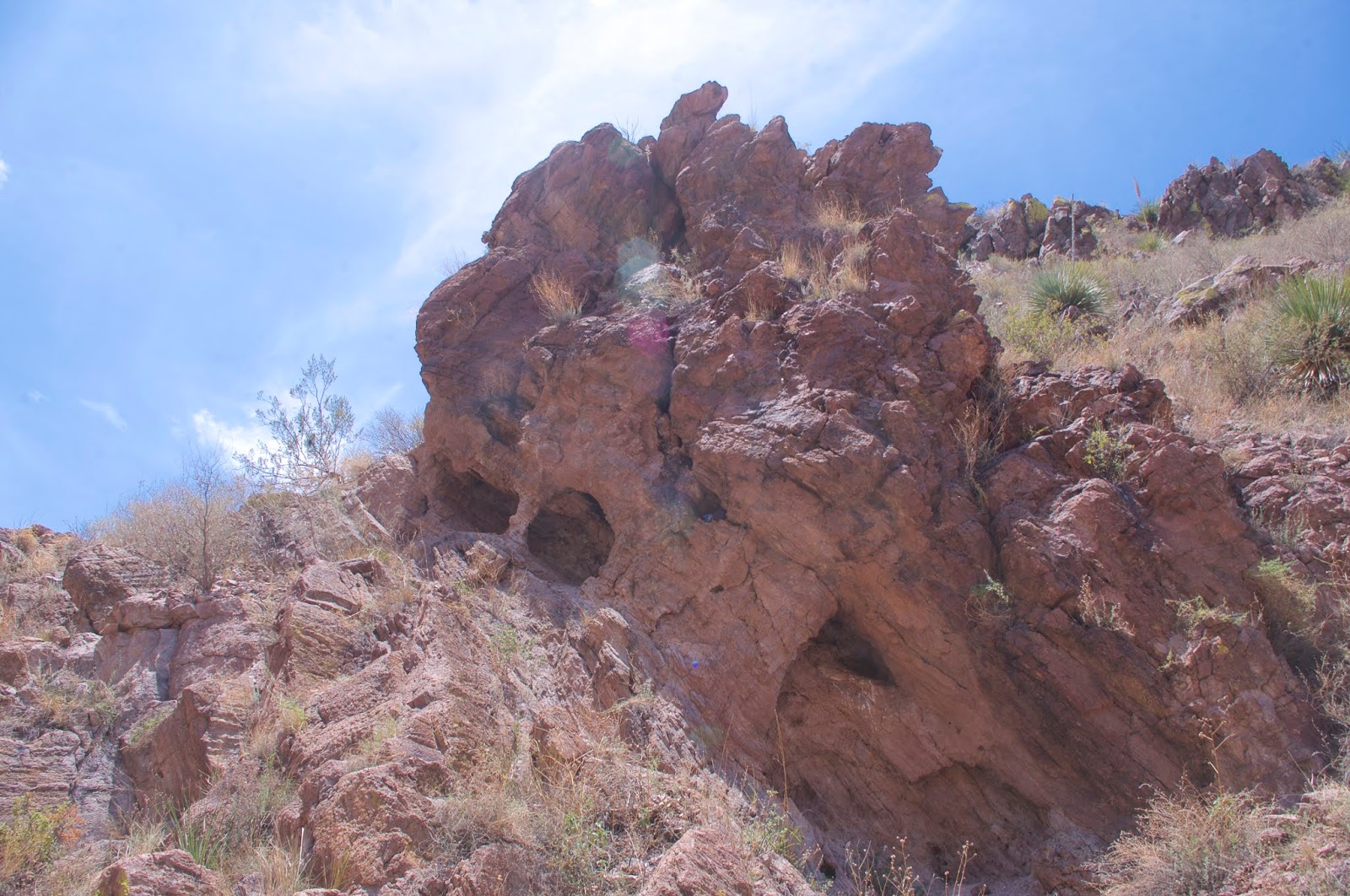
 I climbed up to the jagged, rim of the mini- volcano first.  It was composed of very rough lava twisted into fantastic shapes.

I found the USGS spike right away, and then walked down into the crater bottom 15 feet below.


Walking out the other side and  I circled around and began heading down to the central depression of the entire cluster. Blocky boulders of smooth, dense and gray basalt were exposed on the hill on the northeast side. This struck me as strange in this land of cinders and rough lavas. In the bottom there were iron spikes with with candy cane covers slipped over them driven into the expanse of bare, light colored dirt.


 I walked out along a ravine that drained east. A fissure where lava seemed to freeze in mid-air was on one side. On the other, was a hill of cinders, nearly completely bare except for large ocotillos.


 I  would have liked to have stayed longer, but I was worried that if the clouds went away, the heat would come up fast. They didn't and it didn't, so after sighting the 4Runner it was a pleasant walk back.

Labels: , ,

Thursday, July 26, 2018

Foster Canyon Arches- Organ Mountains Desert Peaks National Monument


 I went out to get a look at a natural arch I spied out here right on a year ago. The summer scene is very different from last year. It has not greened up much whereas last year seems almost lush by comparison. Last year McCall Reservoir was full and overflowing a trickle into the arroyo below. This year, it's just drying mud, although over in Banded Canyon there were small puddles of  clear water from a light rain last night. This year, July has been hot, nearly as hot as June. Last year I was able to get out into the desert multiple times and the heat was never really much of a factor.
 Hopefully the rains are coming in full force and the situation will be remedied soon
 I drove in very close this time and parked in a section of road that's in the arroyo and directly below the red volcanic cliffs on the south side of Foster Canyon that contain the arch. At first I went up to a large alcove, that is developing an arch, only to realize I was in the wrong spot. Not a day to waste a lot of time and energy. I went back down part way and moved over to the west and found an arch, though not the one I had seen last year. So I got a bonus for exploring just a bit  closer.
About 30 feet directly above this lower arch is the opening of the upper one which can be seen from the road if you know where to look. The lower arch's opening cannot be seen until you are nearly upon it.I can stand up in the upper one. The lower one I have to stoop a bit

 I explored on the top of the hill after visiting the second one, looking for a vantage point to get them both in the same photo, but to no avail.
 I explored to the west a bit and found one alcove where someone at some time had built  a bit of retaining wall that was now collapsed, but I found no pottery, no lithics and no petroglyphs.
 I keep hoping that somewhere in the Foster, Faulkner Canyons area there will be some rock art but, so far I've come up empty.
 On the way back I looked down in Banded Canyon at an alcove and found a little cache in a plastic ice cream container. It had 2 bullets, a quarter, a lollipop and a little notebook where people wrote about  finding it and what they took out and what they left behind. I wasn't prepared with a pen, so I just put it back into its little hole in the cliff beside a bottle of water. There was mini arch very nearby.


Labels: , ,

Tuesday, July 24, 2018

Forest Road 634 Camping- Sacramento Mountains, Lincoln National Forest


 There many miles of backroads, most in pretty good shape, in the Sacramento Mountains. Along those roads in the Lincoln National Forest are many beautiful spots for dispersed camping. The only problem is: it's definitely not a secret anymore. While many folk trampled down the same places right outside of Cloudcroft, or used the quickly filled designated campgrounds, many others are in the know that five, ten or fifteen miles away await beautiful, usually peaceful spots in clearings beside narrow, gravel country lanes.

 We got out to one early (before lunch) on Friday. It was a nice wide spot on FR 634, big enough to  easily pull our little trailer around to the back end where there would be a shady forest of fir trees.

Luckily, it wasn't quite big enough that some other camper, many of whom passed by the next two days eyeballing the site, would have felt comfortable setting up as well Although be forewarned, sometimes, especially on long weekend, folks get desperate and do some weird things in the Sacramento and Smokey Bear districts of the Lincoln.

 It was a nice trip. We walked on old, mostly abandoned roads nearby in the mornings and evenings. On Saturday morning we hiked a nice shady section of the Rim Trail ( FT 105) from the FR 634 crossing north to the parking area directly across from Russia Canyon Road ( FR 247). We encountered three motorcyclists and two bicyclists but no other hikers.

 There was a lot of broken glass at our campsite and we picked most of it up, while marveling at the inconsiderate nature of some people ( let's be honest here: men, mostly likely young men) who were not just content to litter, which would have been preferable, but leave behind hundreds of shards of blue, green and brown bottles at a site that gets a fair amount of use, sometimes by families with pets and children.
 Another oddity worth pondering was several fire rings of various ages at the site. I have never felt the need to build a fire ring when there was already one there, but apparently some people ( men, I would guess again) do, as if modifying or repairing existing one wasn't good enough for their purposes.
 We weren't sure if fire restrictions were still in place (they weren't), but we couldn't smell anyone else having fire, and really it wasn't cool enough to have one, unless you were just really desperate to toast marshmallows.
 It was peaceful for sure. No partying type campers showed up in our little neck of the woods. It was a little hot, even at over 9100 feet to do much for most of the afternoon, but the evenings were delightful and once the half-moon had set, the stars and the Milky Way were a joy behold. A local hummingbird visited both days. A butterfly landed on the flower pattern on my wife's shirt. The clearing had abundant elk scat, but we only saw one, a young male, on our last morning there.

Labels: , , , ,

Thursday, July 19, 2018

San Mateo Mountains, Deep Canyon - Cibola National Forest


 Last year, this same week, I visited the amazing box of East Red Canyon. I had wanted to continue the hike into the box/slot of Deep Canyon, one of two major tributaries on its south side. The heat, and worries about approaching thunderstorms had me leave it to another day.
 Another day arrived, with a dry forecast, and so I was off. I parked much closer in this time, right at the  mouth of East Red's box. I  had given thought to driving up on the mesa in between  Deep Canyon and Cold Springs Canyon on FR 984, but when I looked at the thick gravel of a roadbed barely incised into the side of the steep hill, I changed my mind. If I had done it, I would have cut out walking through East Red and then very wide lower end of Deep Canyon, by scrambling down to the mouth of the box of Deep from the mesa.
Going on foot seemed preferable to white knuckling up the hill on the road plus whatever driving mysteries that awaited on top. The walking was easy on the level gravel of East Red and soon  I was turning up Deep Canyon walking through its narrow mouth into a wide valley with grasses, piñons and junipers.


It was plenty warm already even though it hadn't reached 10:00 yet. The hike though, was more pleasant that I would have imagined. Bunnies darted out of the shrubs as  I cruised on the cow paths. Soon the gentle hills on either side stopped and the cliffs of volcanic rock, low at first, began. They got higher, not quite as high or sheer as East Red, but almost. The canyon  bottom was much narrower than East Red as well.  While East Red had hackberry, walnut and boxelder pressed hard against the cliffs with the wide gravel channel in between, Deep Canyon was more like a low elevation forest environment. Oaks, straight growing junipers, piñons, plus New Mexico locust, cholla and grasses along with very occasional small boxelder and walnut made the going a bit thick at times even with the wildlife paths to follow.


There was even one very photogenic ponderosa pine and few of its offspring in the shadow of the tallest pock marked cliffs where the temperatures are cool enough for them to survive.

 Cackles of canyon wrens echoed off the walls of rock, but with the continuing dry conditions, only slightly relieved in the last few weeks, the place was remarkably devoid of the sounds of wildlife. After getting to its narrowest passage that cuts through a lower shelf of bedrock, the box canyon opens up with the craggy rust colored cliffs giving way to the sun baked grass and cholla covered slopes again.  As the temperature was closing in on 90 degrees, and my shade was now gone, I turned around.


On the way back, I looked for likely looking alcoves that ancient peoples could've utilized but found no sherds or lithics as I had last year in East Red. I lunched around noon in the shade of the cliffs and junipers near the entrance to the box.  I climbed up on bench on the east side to walk most of the way back to the confluence.  I gave some thought to climbing up to the mesa to walk along the south side of East Red on the mesa, but it was just plain old hot at this point, and I opted for shade of the canyons.


 This is an awesome area for exploring. If it was close to Santa Fe or Albuquerque it would be packed with people every weekend. A really great loop hike would be to go up East Red, then Deep Canyon and then come back down the box of Cold Spring Canyon. Unfortunately, much of the box of Cold Spring is private property. Still, one could go up on the mesa and use it for the return leg.