Monday, April 20, 2015

Mineral Creek, North Percha Creek Hike- Gila National Forest


We parked the car just off of  FR 157S at the dispersed camping area just above (west) of the Mineral Creek, Carbonate Creek confluence. I'm never sure if the stretch of creek below the confluence and before its meeting with  North Percha downstream is technically Mineral Creek or Carbonate Creek.  It always seemed to me that Mineral is a tributary of Carbonate, but it looks like the map makers have it the other way around.
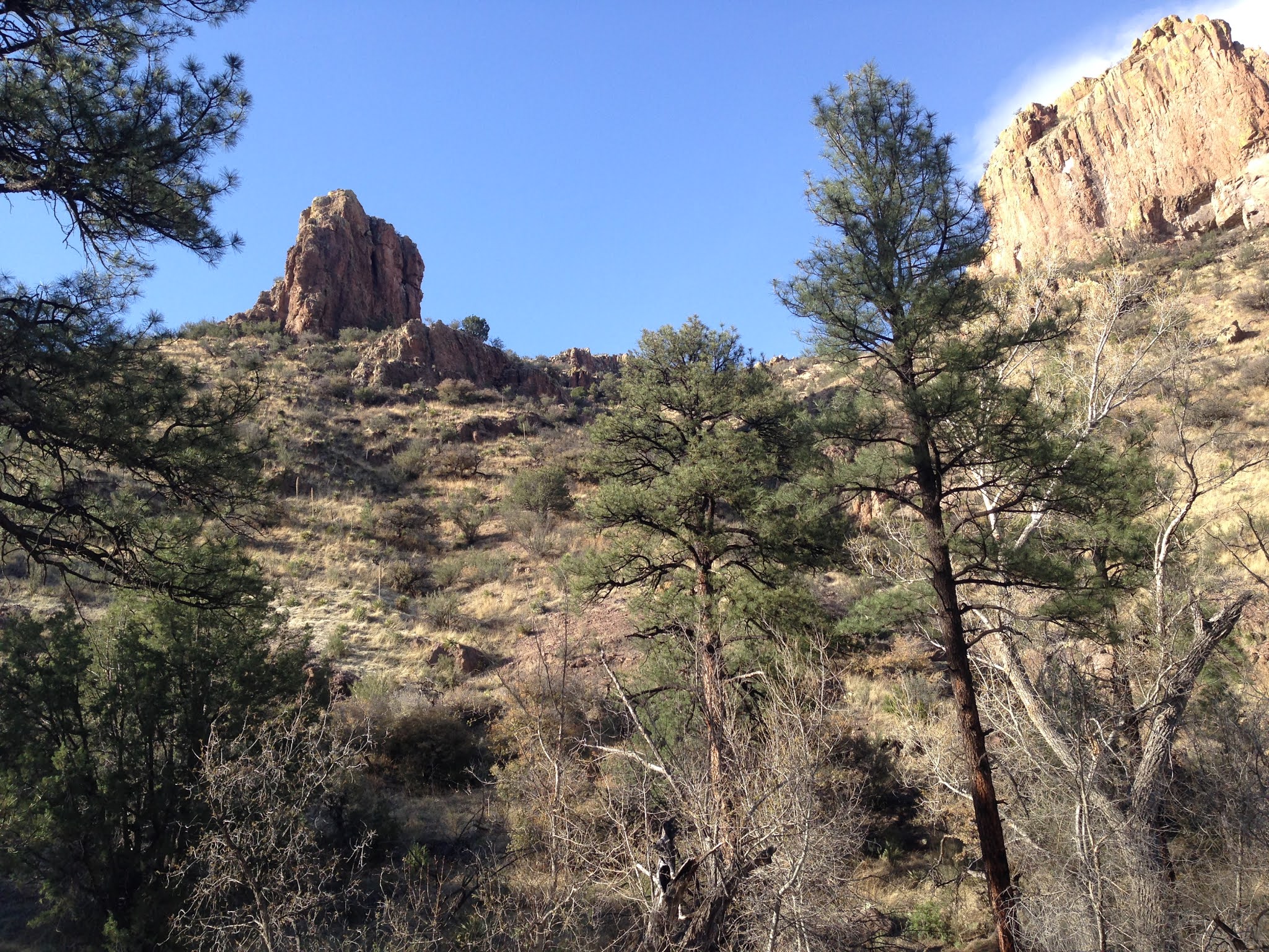
  We started off crossing the creek at the back of the campground and began following a good cow/ hunter/ wildlife trail on the south side of the creek. I'd been down here once before many years ago while camping on upper Carbonate. We made it down to the fence line that separates Forest and private property and then turned back for a short outing. Now my plan was to hike down Mineral to the confluence with North Percha and then hike up that creek, taking in the two little box canyons they've cut in the massive limestone that runs  north to south through this section and all along the foothills of the Black Range.
 In  a short ways we came to the section of the creek I call " the chute." Here the creek runs over smooth, gray rock water slides and gathers deep pools in carved out hollows. On the hike many years ago we avoided this section by using a good cow trail that goes around and above on the north side (there's one on the south side too, although it looks  decidedly more treacherous). This time Seamus and I headed straight in. Soaking  myself up to the knees could not be avoided at the first pool, but we were able to skirt around  a second deeper one without too much trouble. Seamus doesn't mind water, but he surely tries to avoid any actual swimming, which is probably good because I've read it's not really a strong suit for the very dense and short legged Scottie.


 The creek disappears under thick gravel beyond the pools but emerges again weakly past the last straight section of the chute. Further down, though, is where it really comes to life, due the presence of  many springs burbling out at the base of the cliffs on either side of the stream. These are  considered warm (not hot by any stretch) springs, which may also account for the heavy algal growth in this area. There is cress and mint growing in abundance here as well.  Canyon grape, just beginning to show leaves, hung from branches. Larger alders and cottonwoods that towered over head were just budding out. Box elder, elm, willow and walnut had already leafed out in that electric green of early spring. This abundant tree life is surely a testament to the fact that these are perennial springs, unlike ones that I've seen dry up on upper Mineral Creek.


 Though it looked a little raw still, and has not been immune from the alterations due to flooding (there had been an obvious shift of the channel recently) and needs a good long rest from cattle, this little riparian area would be a beautiful place  for a  picnic in the summer, or better still on a fall color walk in October or early November.
  Adding to my interest were the many cracks, alcoves, and holes all along the limestone cliffs. Many were inaccessible, and probably most terminated shortly after their entrances, but at one of these cave openings someone had bothered to build a makeshift ladder in order to explore.
 Temptation to climb was very minimal, as the ladder was probably more dangerous than anything I might encounter in the cave, but my curiosity was greatly stirred.


 The confluence with North Percha is just above the fence line.  We started to head upstream now on that creek. Initially it was very similar to the section of Mineral Creek we had just been on, with  large trees, springs emerging from holes in the rock, and early stages of creekside greenery just sprouting. Further up however, the stream channel widens considerably and becomes  dry gravel wash for  a long stretch . Deciduous growth dwindles to a few seemingly misplaced cottonwoods right in the streambed. I was glad the clouds moved in, for this would have been a much warmer part of the hike if they hadn't.


 There were several areas where the stream narrowed itself  into channels of bare rock with tiny falls and waterslides  to keep our interest up. Here, too, were the many tears and punctures into the cliff sides signaling the potential for  a cave that penetrates deep into the mountain. I know there is at least one cave that people do visit along this section of the North Percha, but I began to wonder how thoroughly has this area been explored by folks who do that sort of thing?


 Eventually there was a good trail to follow through the tall pines, as we walked along with the now flowing again creek below us. We passed  a  trail of sorts coming down the hill from the south that was marked with bright tape. I 'm pretty sure this one is used by folks who want to access the cave as a bypass around the private property along the road( FR 157S) just a short ways upstream.  When we saw the  buildings and such of one of the private inholdings, we turned around.

 On the way back, we checked out two of the more accessible caves on a lower shelf of rock. They were strewn with large boulders at their entrances, and I didn't dare go in, but they at least looked like they continued on.

 Back at the confluence, I stared down the glade of tilting alder trees and hoped that the folks who own this little stretch of creek in the Gila don't take it for granted. I know I wouldn't.

Labels:

Tuesday, April 14, 2015

Circle Seven Creek camping- 2015


We sold our little trailer two years ago. On an attempted camping  trip to Rockhound State Park, a  broken part that wouldn't allow us to use our propane cylinder was the last in an almost never ending series of malfunctions that put us over the edge. That, and the fact that it was just too small and without a bathroom. Even though the thing put us out in the forest  and desert to camp, much, much more than we ever would have had we still been tent camping, it was a headache from the get-go. Rare, and I mean very rare were the trips where everything worked as it should,or some significant damage didn't occur.  So,before I relate the following camping story, I must ask anyone out there, Is this just how it is with trailers, or perhaps with camping in general? Is the nature of the entire enterprise that  things will go wrong and wrong and wrong?
 More or less on a whim, we bought a new tent and a new camping stove  and decided to go tent camping for the first time in 10 years. We chose one of our favorite old spots: Circle Seven Creek. Now, if you search through archives of this blog, you will discover that at times we definitely have a taste for the remote in our camping choices. Circle Seven Creek on the northeast edge of the Aldo Leopold Wilderness in the Gila's Black Range is about as remote as car camping gets in the southern half of the state.
 Off we went on Friday( Good Friday) morning. After checking  with the Forest Service in T or C about trail conditions and buying some new maps to replace my well worn ones from 1998, we got a sandwich and were on our way.
 Past Winston, Chloride and the St. Cloud zeolite  mine we got onto Forest  Road 157. I'm happy to report road conditions on this formerly  horrendous bone and kidney rattler have improved substantially, though progress on it is quite slow for us city folk. Still, it was a welcome change, if, perhaps only a temporary one. The road follows Monument Canyon, then traverses a mesa to then follow North Fork Palomas( both had water) and then crosses another mesa to follow Circle Seven Creek. It's really a  beautiful drive through open meadows, mesas and hills. Just before traversing another upland area, we turned at the windmill and tank that marks the beginning of the Circle Seven road( FR 730). This road is one lane job that hasn't improved at all. The stream crossings were steep enough to bounce the rear end of the pick-up several times, and our clearance is not too shabby. But I was happy to see  the creek flowing for the first time in four visits, and we persevered  until we found the perfect spot to camp.
 We got the tent  and our camp set up without too much trouble. The weather was gorgeous, and  the burbling creek a few feet away gave an all's right with the world feeling to our expedition. My wife asked me to move the truck a 90 degree turn from where it was parked. I obliged, got in and turned the key. Nothing. Not a single rumble or crank. Nothing.There was an immediate desire to panic. We were well out of cell range, down a little used side road in a very remote section of the Gila that sees virtually no people apart from fall deer and spring turkey hunting seasons. Although we had passed a very few ranch houses once  on FR 157,  it was highly unlikely we would find any help any closer than the Winston-Chloride area over a dozen miles away.
 I walked down to the truck and trailer we had passed on the way in and left a note, but we had no way of knowing if  whoever it belonged to was just out for the day or several days. I went out for a second walk later to the very end of Circle Seven Road and even climbed a few hills in a vain attempt to get some cell service.
 As I got back to camp where my wife was cooking dinner, I had only begun to wrap my mind around the idea that my plans  for getting to Diamond Peak were done for, and that the only walking I'd  be doing tomorrow would be toward Winston and Chloride to get help,  when I  heard a man's voice coming from down the trail as if directing some animals.And then, within seconds, a pack of 22  dogs quietly invaded our campsite, soon followed by their owner on horseback. It was a hilarious scene reminiscent of the Bumpus dogs in " A Christmas Story" as they calmly tried to eat and drink everything in sight. I  very briefly talked with the man that was their leader , David Welty, who had been out mountain lion hunting all day, and I'm sure he was as tired and hungry as his animals, yet he led them all down the road  and put them in his trailer ( no small feat I'm sure)which he had to  unhook, and drove back up and gave us the jump start and even offered further assistance if we needed it.  Mr. Welty seemed like someone I would respect no matter how our views may differ, a quiet, unassuming individual to which we are very indebted.
 We drove the hour and a half to T or C only to see the two auto parts stores were closed and have Walmart sold out of the right battery. We had little choice but to stay the night  and chose the Ace Lodge for sentimental reasons( many years ago we had car trouble out in the San Mateo Mountains and had to stay the night in T or C as well)  and for the short walk it would be to the auto parts store. With the help of some wine and beer from the nearby Los Arcos drive-up liquor store, we passed the rest of the night pleasantly enough despite the circumstances.
 The  next morning, I walked down to the O'Reilly and purchased a battery and with a lift and help from a very nice young fellow who worked there, we were on the road( after stopping at the hopping McDonalds for breakfast) and back to our campsite by 9:45 and shortly thereafter on the trail.
 After our hike( see previous blog), we had a good dinner and a nice fire, but spent a rather cold night in the tent and wished we could have borrowed a  few of those dogs for warmth, despite Seamus doing his best to be a little heater.
 Sunday morning was beautiful and we walked to the end of the road after exploring Whiskey Spring Canyon a bit.


 our beautiful camping spot


Labels: ,

Tuesday, April 7, 2015

Circle Seven Creek Trail ( FT 106)- Aldo Leopold Wilderness


 IMPORTANT UPDATE ( June, 2022): The Black Fire has burned through this valley. It will be vastly altered from what is seen here.

We set out for the Gila on Friday morning( 4/4/15) with high hopes of conquering Diamond Peak using the Circle Seven Creek Trail on Saturday. I had no information other than 13 year old book. We stopped by the Forest Service offices  and talked to the trails man, but he had nothing to offer. The best information came from Mr. David Welty (more on him in the following blog) of Winston, a mountain lion hunter we met coming down the Circle Seven Road  Friday evening. What he told us was not good, but was absolutely correct as it would turn out. Yet, he was unassuming enough not to attempt to discourage us, which I appreciated.


 We got  a late start due circumstances that will be told in a following blog, still, since we would have a  nine or so hours of daylight, we still had at least some hope that we could accomplish this as a long day hike (14-15 miles round trip, but still the shortest route to the peak).
 It was a perfect spring morning: windless, cool and cloudy enough to keep the sun off us and our black dog. We had hiked the lower couple of miles more than  ten years ago (see Circle Seven Creek Camping in this blog) on  an unseasonably hot early fall day when the creek was dry, but  now the green of the willows, the budding cottonwoods and good flow of clear water in creek made all the difference in the world. After leaving the road behind, there isn't much room for a trail at first and we crossed the creek many times in a very narrow section of the valley that cuts through solid rock, watching our Scottie drink and cool himself as we went.


When the terrain opened up again, the trail reappeared, although Seamus disappeared in last years lush growth of   bunch grass that grew in large meadows near the Upper Circle Seven well and corral, which is the boundary for the Aldo Leopold Wilderness. Above and below this well  for  short distances, and one short stretch at the beginning of the burn were only sections of the creek that were dry.


  The forest here is mostly an open deciduous oak ( still bare at this time of year) and juniper woodland with occasional cottonwoods, alders along the stream. Walnut trees( also bare) are here, as well as  Arizona cypress, pines and an occasional fir that provided the only and welcome shade this early in the season.
 This open section ends at the mouth of the North Prong which was flowing as well.The confluence is a little confusing ( the creeks are very similar in size ) for staying with the trail as it stays with the main creek only by taking a sharp turn to south.The trail-less North Prong would make for fun exploration itself- the cliffs and rock formations rise high and steep over the tiny piney valley. Circle Seven Creek now became a much different place. Big vistas of hills and massive cliffs were hidden now, but trail and creek took on an intimate, utterly charming beauty with small  cascades and deep clear pools. It looked very much like the trout streams I've fished in other parts of the Gila, and that it may have once been.


At Deadman Canyon, which was also flowing,  there was the bit of trail finding as our trail again turned sharply to the south. The even narrower little canyon of Deadman might make a fun hike as well, and I've been told there is a hundred foot waterfall way back where the slopes of two mountains collide.
 Past Deadman things began to open a bit again, On the dry south facing slopes were scrub oak, mountain mahogany and low juniper. The north facing slope had only  a sparse growth of evergreens and the yet to leaf out low growing shrubs.  This has been this way for awhile unlike areas further south in the Black Range which had a thick growth of pine and Douglas fir before the Silver Fire two years ago. Really  this entire area is a very dry part of the already dry Gila. The riparian areas are the only really lush parts of the forest.
 Then we entered the burn area. The riparian growth  of  large trees was gone, replaced by the aforementioned brushy oak and thorny locust. The gray brown hillsides  were thick with a low growth of gambel oak punctuated with hundreds of black pine snags. It would've been a much prettier scene had  the oak and locust leafed out already, as it was, it looked wild, desolate and very much like a place that people don't belong, at least not for long. The trail was gone, as were most of the blazes. There were occasional cairns and a bits of blue tape tied to shrubs, but they weren't really all that helpful as our speed was most likely cut in half now, and our momentum lost. We stopped to eat in grove of tall, tall pines that had escaped the flames.


 After lunch, the now trail-less hike only became rougher as we  searched for blazes, cairns and short stretches of tread, but mostly following the ground disturbed by cattle and elk. Along the way there were leafed out chokecherry and lemonade bush  creekside providing a bit of electrifying green to the drab scenery. My wife decided to stop at a sweet little area  where the stream cascaded between huge boulders and  a few large pines that still lived amongst the dead.


I continued on now very steeply up hill and high above the creek bottom, still finding the occasional blaze or cairn and even some rusty spools of barbed wire, as I slid on gravel, climbed over downfall and pushed through brush. A huge cone of rock, with large alcoves at the bottom, topped a huge mountain that would not have looked out of place in the desert, on the north side of the valley. On the south  was the  high ridge of the Black Range looking gray. I gave up and stopped at an old blaze on an alligator juniper. At least a mile and a half and 1600 feet below our destination. I could not even see Diamond Peak, but I did spy a small grove of small aspen in pocket below the ridgeline which brought smile to my face.


Rolls of rusty barbed wire high on the "trail"


The last blaze on the non- existent trail

It was not meant to be today. The clouds had made getting this far even possible. Had the sun come out, it would have been unbearable in this completely open terrain.  I reunited with my wife and we began our long descent. The sun did come eventually, but luckily we were already back in the shady stretches. We rested more often and still marveled at the pretty little stream, the first growth of wildflowers and our good fortune to be in this magnificent setting on this perfect day. NOTE: as you may have gathered I can't really recommend this route as  a way to access Diamond Peak or the CDT trail.


Labels: