Circle Seven Creek Trail ( FT 106)- Aldo Leopold Wilderness


IMPORTANT UPDATE ( June, 2022): The Black Fire has burned through this valley. It will be vastly altered from what is seen here.
We set out for the Gila on Friday morning( 4/4/15) with high hopes of conquering Diamond Peak using the Circle Seven Creek Trail on Saturday. I had no information other than 13 year old book. We stopped by the Forest Service offices and talked to the trails man, but he had nothing to offer. The best information came from Mr. David Welty (more on him in the following blog) of Winston, a mountain lion hunter we met coming down the Circle Seven Road Friday evening. What he told us was not good, but was absolutely correct as it would turn out. Yet, he was unassuming enough not to attempt to discourage us, which I appreciated.

We got a late start due circumstances that will be told in a following blog, still, since we would have a nine or so hours of daylight, we still had at least some hope that we could accomplish this as a long day hike (14-15 miles round trip, but still the shortest route to the peak).
It was a perfect spring morning: windless, cool and cloudy enough to keep the sun off us and our black dog. We had hiked the lower couple of miles more than ten years ago (see Circle Seven Creek Camping in this blog) on an unseasonably hot early fall day when the creek was dry, but now the green of the willows, the budding cottonwoods and good flow of clear water in creek made all the difference in the world. After leaving the road behind, there isn't much room for a trail at first and we crossed the creek many times in a very narrow section of the valley that cuts through solid rock, watching our Scottie drink and cool himself as we went.


When the terrain opened up again, the trail reappeared, although Seamus disappeared in last years lush growth of bunch grass that grew in large meadows near the Upper Circle Seven well and corral, which is the boundary for the Aldo Leopold Wilderness. Above and below this well for short distances, and one short stretch at the beginning of the burn were only sections of the creek that were dry.


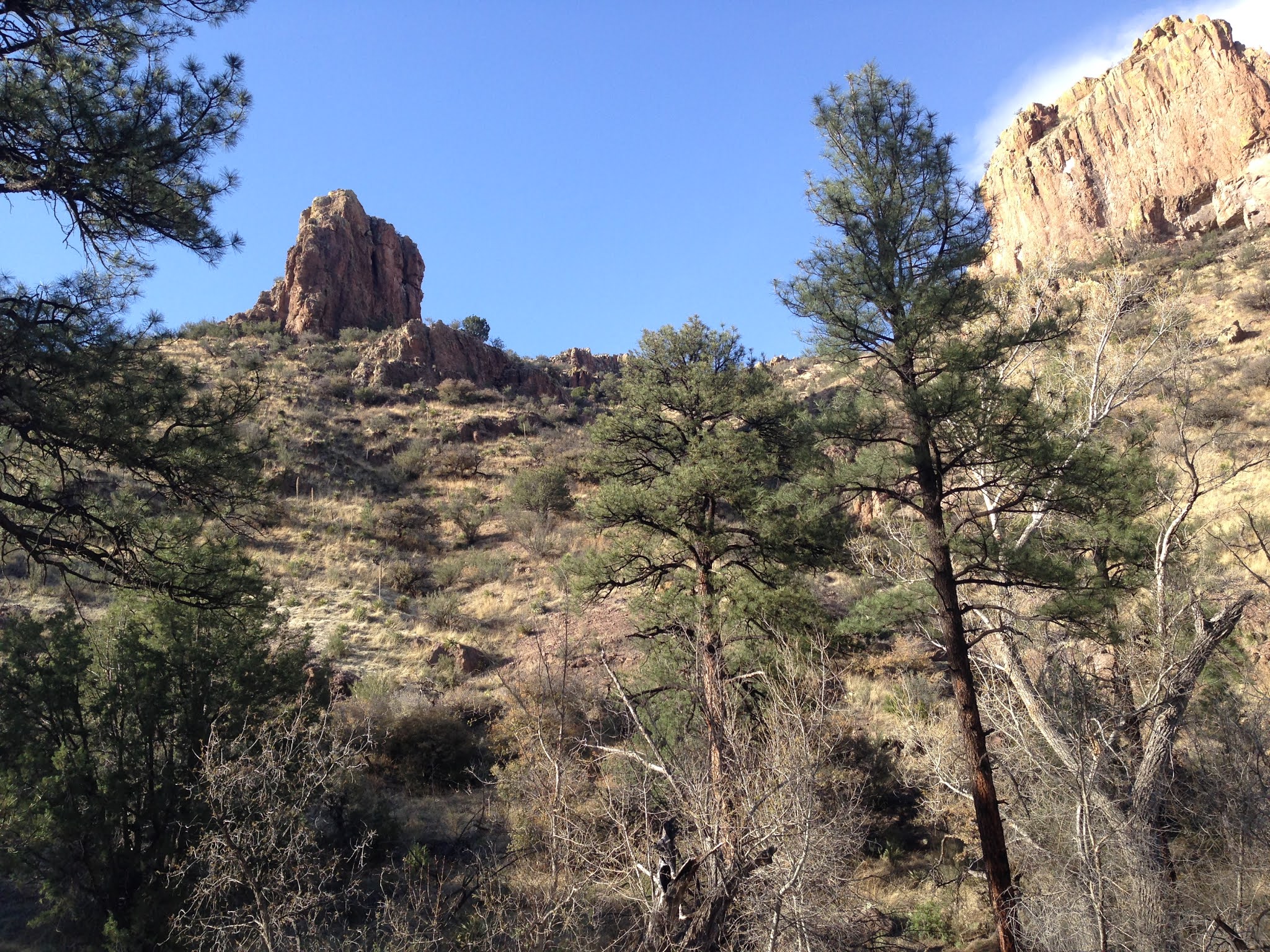
The forest here is mostly an open deciduous oak ( still bare at this time of year) and juniper woodland with occasional cottonwoods, alders along the stream. Walnut trees( also bare) are here, as well as Arizona cypress, pines and an occasional fir that provided the only and welcome shade this early in the season.
This open section ends at the mouth of the North Prong which was flowing as well.The confluence is a little confusing ( the creeks are very similar in size ) for staying with the trail as it stays with the main creek only by taking a sharp turn to south.The trail-less North Prong would make for fun exploration itself- the cliffs and rock formations rise high and steep over the tiny piney valley. Circle Seven Creek now became a much different place. Big vistas of hills and massive cliffs were hidden now, but trail and creek took on an intimate, utterly charming beauty with small cascades and deep clear pools. It looked very much like the trout streams I've fished in other parts of the Gila, and that it may have once been.


After lunch, the now trail-less hike only became rougher as we searched for blazes, cairns and short stretches of tread, but mostly following the ground disturbed by cattle and elk. Along the way there were leafed out chokecherry and lemonade bush creekside providing a bit of electrifying green to the drab scenery. My wife decided to stop at a sweet little area where the stream cascaded between huge boulders and a few large pines that still lived amongst the dead.


I continued on now very steeply up hill and high above the creek bottom, still finding the occasional blaze or cairn and even some rusty spools of barbed wire, as I slid on gravel, climbed over downfall and pushed through brush. A huge cone of rock, with large alcoves at the bottom, topped a huge mountain that would not have looked out of place in the desert, on the north side of the valley. On the south was the high ridge of the Black Range looking gray. I gave up and stopped at an old blaze on an alligator juniper. At least a mile and a half and 1600 feet below our destination. I could not even see Diamond Peak, but I did spy a small grove of small aspen in pocket below the ridgeline which brought smile to my face.


It was not meant to be today. The clouds had made getting this far even possible. Had the sun come out, it would have been unbearable in this completely open terrain. I reunited with my wife and we began our long descent. The sun did come eventually, but luckily we were already back in the shady stretches. We rested more often and still marveled at the pretty little stream, the first growth of wildflowers and our good fortune to be in this magnificent setting on this perfect day. NOTE: as you may have gathered I can't really recommend this route as a way to access Diamond Peak or the CDT trail.


It was a perfect spring morning: windless, cool and cloudy enough to keep the sun off us and our black dog. We had hiked the lower couple of miles more than ten years ago (see Circle Seven Creek Camping in this blog) on an unseasonably hot early fall day when the creek was dry, but now the green of the willows, the budding cottonwoods and good flow of clear water in creek made all the difference in the world. After leaving the road behind, there isn't much room for a trail at first and we crossed the creek many times in a very narrow section of the valley that cuts through solid rock, watching our Scottie drink and cool himself as we went.
When the terrain opened up again, the trail reappeared, although Seamus disappeared in last years lush growth of bunch grass that grew in large meadows near the Upper Circle Seven well and corral, which is the boundary for the Aldo Leopold Wilderness. Above and below this well for short distances, and one short stretch at the beginning of the burn were only sections of the creek that were dry.
The forest here is mostly an open deciduous oak ( still bare at this time of year) and juniper woodland with occasional cottonwoods, alders along the stream. Walnut trees( also bare) are here, as well as Arizona cypress, pines and an occasional fir that provided the only and welcome shade this early in the season.
This open section ends at the mouth of the North Prong which was flowing as well.The confluence is a little confusing ( the creeks are very similar in size ) for staying with the trail as it stays with the main creek only by taking a sharp turn to south.The trail-less North Prong would make for fun exploration itself- the cliffs and rock formations rise high and steep over the tiny piney valley. Circle Seven Creek now became a much different place. Big vistas of hills and massive cliffs were hidden now, but trail and creek took on an intimate, utterly charming beauty with small cascades and deep clear pools. It looked very much like the trout streams I've fished in other parts of the Gila, and that it may have once been.
At Deadman Canyon, which was also flowing, there was the bit of trail finding as our trail again turned sharply to the south. The even narrower little canyon of Deadman might make a fun hike as well, and I've been told there is a hundred foot waterfall way back where the slopes of two mountains collide.
Past Deadman things began to open a bit again, On the dry south facing slopes were scrub oak, mountain mahogany and low juniper. The north facing slope had only a sparse growth of evergreens and the yet to leaf out low growing shrubs. This has been this way for awhile unlike areas further south in the Black Range which had a thick growth of pine and Douglas fir before the Silver Fire two years ago. Really this entire area is a very dry part of the already dry Gila. The riparian areas are the only really lush parts of the forest.
Then we entered the burn area. The riparian growth of large trees was gone, replaced by the aforementioned brushy oak and thorny locust. The gray brown hillsides were thick with a low growth of gambel oak punctuated with hundreds of black pine snags. It would've been a much prettier scene had the oak and locust leafed out already, as it was, it looked wild, desolate and very much like a place that people don't belong, at least not for long. The trail was gone, as were most of the blazes. There were occasional cairns and a bits of blue tape tied to shrubs, but they weren't really all that helpful as our speed was most likely cut in half now, and our momentum lost. We stopped to eat in grove of tall, tall pines that had escaped the flames.
After lunch, the now trail-less hike only became rougher as we searched for blazes, cairns and short stretches of tread, but mostly following the ground disturbed by cattle and elk. Along the way there were leafed out chokecherry and lemonade bush creekside providing a bit of electrifying green to the drab scenery. My wife decided to stop at a sweet little area where the stream cascaded between huge boulders and a few large pines that still lived amongst the dead.

I continued on now very steeply up hill and high above the creek bottom, still finding the occasional blaze or cairn and even some rusty spools of barbed wire, as I slid on gravel, climbed over downfall and pushed through brush. A huge cone of rock, with large alcoves at the bottom, topped a huge mountain that would not have looked out of place in the desert, on the north side of the valley. On the south was the high ridge of the Black Range looking gray. I gave up and stopped at an old blaze on an alligator juniper. At least a mile and a half and 1600 feet below our destination. I could not even see Diamond Peak, but I did spy a small grove of small aspen in pocket below the ridgeline which brought smile to my face.

 |
| The last blaze on the non- existent trail |
It was not meant to be today. The clouds had made getting this far even possible. Had the sun come out, it would have been unbearable in this completely open terrain. I reunited with my wife and we began our long descent. The sun did come eventually, but luckily we were already back in the shady stretches. We rested more often and still marveled at the pretty little stream, the first growth of wildflowers and our good fortune to be in this magnificent setting on this perfect day. NOTE: as you may have gathered I can't really recommend this route as a way to access Diamond Peak or the CDT trail.


Labels: hiking
posted by Devon Fletcher at
10:36 PM
![]()
![]()


0 Comments:
Post a Comment
Subscribe to Post Comments [Atom]
<< Home