Thursday, March 31, 2022

Ruins - Sierra County


I discovered a couple of years ago while trying figure out where several ruins on the Cibola National Forest were, that sometimes they are hiding in plain sight. Many " ruins" sites, but not all, are indicated on USGS topo maps. If they are on USGS topos, then they are also on On-X ( which I have) or other similar apps. Still, it was unexpected for me to find one of these " ruins" locations fairly close to home while scanning topos ( using my topo app for MacBook Air) recently. I had had a passing interest for many years in a site called La Capilla de Don Silverio, while looking at a map that covers the region just to the northwest of Hatch, New Mexico. It seemed odd to have a small chapel on the relatively remote, and mostly roadless west side of the river in this area. More recently I got the notion to find the spot on Google Earth. I did, but now it is known as the Santo Niño de Atocha Shrine.

 Back to the topo scanning, I found, just over the line in Sierra County, in one of the branches of the Arroyo Cuervo in little letters, with a couple of little boxes, a " ruins" indicated about a mile and a half up the wash from the Shrine or Capilla( chapel). Well, that was exciting. I quickly began looking at Google Earth and yes, there was something to see there, especially when I looked at images going back to 2011. It didn't look like much, but I was still excited.

A bit of problem, I surmised, correctly as it turns out, that this area receives heavy off- roading use ( which is prohibited by the BLM of course). I did not want to visit on a weekend. Problem resolved: on the Friday of my Spring Break, I just decided to go for it and drove out there after lunch. It was only slightly tricky getting there. I took a road that I thought was Arroyo Cuervo Road at an intersection and had brief detour that probably only totaled 10 minutes or so. Back on track, I drove the well maintained actual Arroyo Cuervo Road to more or less its formal end just past the Shrine and parked next to a juniper tree. A couple was standing there looking out to the desert ( I had passed their parked van moments before), and I felt bad for disturbing them on this deadly quiet warm Spring afternoon. I asked if they were going to the chapel. I guess they had already been, but they told me it was open. I  marched up the steep sandy road buttressed with old tires, slid the bolt of the door and entered this strange place. 

Santo Niño de Atocha Shrine

There were candles, statues and other images of Catholic iconography. There were photos too, of families and loved ones. I felt a little profane and resisted any temptation to take photos. Instead, I knelt down at the single kneeler that had a  worn bible on its shelf and instantly remembered that it would be one year since my very best friend, David Soules, had died. I mumbled the Lord's Prayer and left quickly. I had talked to David once about this place. He had definitely noticed it too. I don't know if he ever visited here. I don't know if he knew about the ruins on the topo either. But now I felt I had him with me. When a dust devil softly crept up from behind me as I made my way up the wide, sandy wash moments later, it seemed strangely appropriate with the sand brushing against my neck that gave me a chill down to my feet. When I realized what it was, I smiled, and felt a few moments of blissful calm as it danced off into the brush.

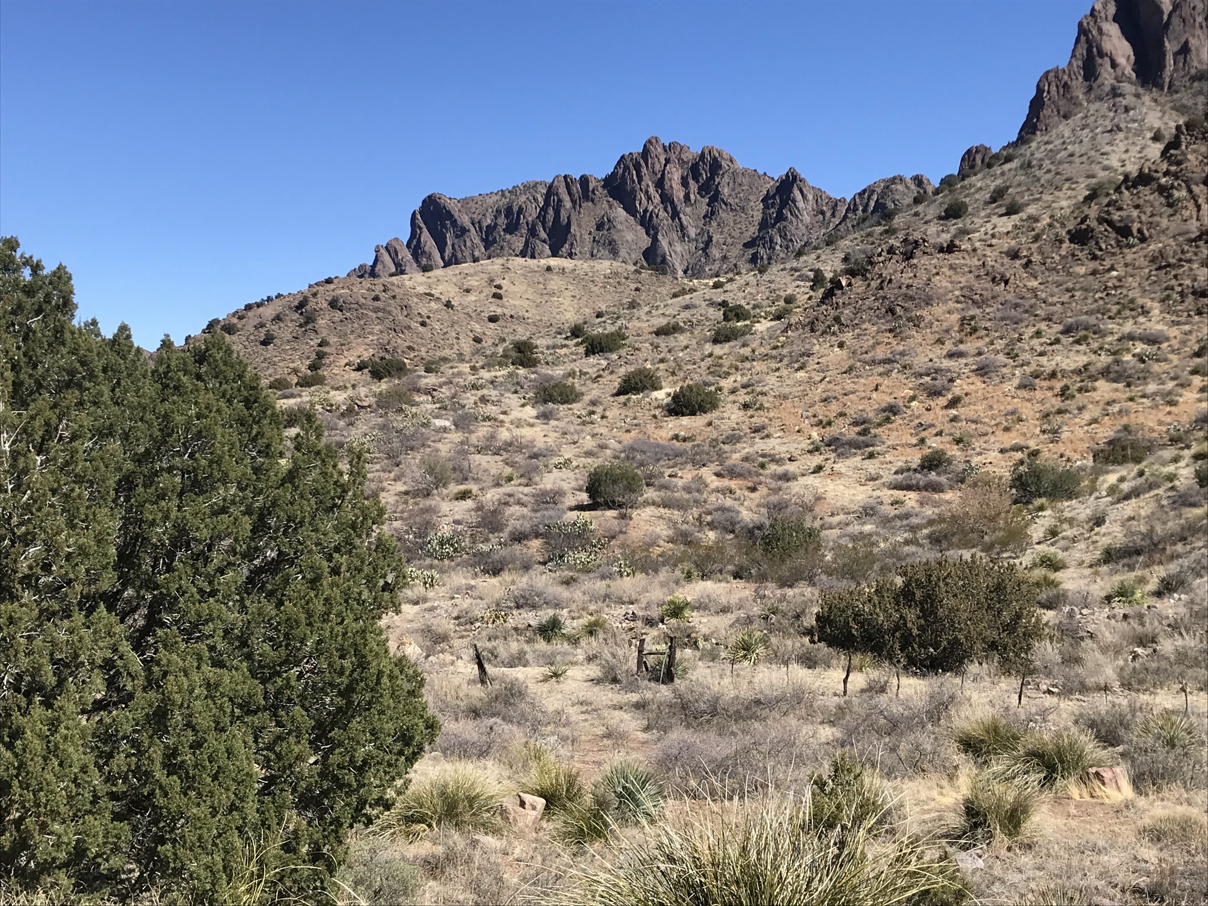
 Nutt Mountain sticking up on the horizon

 It was warm. Really too warm for this little trek, but I motored on. It felt as if I was no longer in the southern New Mexico desert, but something transitional. Eventually, my app told me I had reached the spot and I lumbered up out of the arroyo onto the brushy banks. Sure enough within seconds, I was seeing the foundation walls, surrounded now by a mound of disintegrated adobe, I had been straining at for weeks on Google Earth. There appeared to be three bedroom size structures, plus a large area that was devoid of vegetation.

Stone foundations
Stones from the foundation

 I searched the whole area over at least  three times, but really saw nothing that I was 100% convinced was an artifact. There may have been some broken pieces of manos and metates, and maybe a bit of lithic debitage, but really there just wasn't anything like what I  have found at other habitation sites. This might be expected as the wash is easily driven and the place may have been picked clean over the many years. It could also have been excavated at some point in the past as well, I don't know.

 I began to have a little doubt creep in as to the nature of the age of the ruins. Were they made  by ancient Native Americans or from some more recent era? I believe that map makers only use the designation for pre-historic ruins in Southwest, plus there was very little in the way of 19th or 20th century artifacts about to make me feel otherwise.

 On my way in I had noticed a muddy spring just downstream of the ruins, which of course explained why the ruins were there in the first place- similar to when we visited the Gallinas Springs Ruins near Magdalena. I looked around the opposite stream bank in the vicinity of the spring with its aged cottonwoods, but there was little else to find in the way of evidence for  ancient human  habitation. I headed back mostly on the banks, and not in the wash. I saw several deer climb upon the upper benches at my approach.

 Deer 

 I trudged through, up and over the dunes of pale red sand until I was back at my truck. I had been in a hurry much of the time, a bit paranoid about encountering a partying crowd that might show up on a Friday afternoon. I'm never far from my neurotic self, but there was ample evidence in the form of tracks, beer cans, bottles, shot gun shells and more, that at least my imaginings were not completed unfounded.

 I would like to know more about these places. I would like to visit in less of a rush one day. I drove home uneventfully.

 La Capilla de Don Silverio

 NOTE: Most of this hike is on BLM or State Trust Lands, however the ruins themselves are on small parcel of un-posted private property. Please be respectful if you go.

Tuesday, March 29, 2022

Florida Mountains - BLM and State Lands

Baldy Peak in center


So, I've also been trying to make it out to the Floridas or Little Floridas at least once a year as well. Truly, if they were a just a little bit closer to home, I'd be out there all the time. Second only to our own Organ Mountains here in Las Cruces as beautiful desert ranges go, it's amazing to me that the main Floridas seem to be a place known for hunting Persian Ibex and not much else. Spring Canyon, which is part of Rockhound Stat Park does receive a decent amount of visitors and people use Windmill Canyon occasionally to climb to Florida Peak, the range's highpoint, but there are many areas of both State and BLM lands that probably see very few, if any people. I speculate the main reasons for the dearth of visitors lie in  the facts that the access to many areas is not only rough but confusing ( above mentioned Spring Canyon being the exception with a nice paved road all the way to the parking area) and that there are no well established human engineered trails ( Lover's Leap Canyon, a well trod use trail also starting from Spring Canyon perhaps the only exception).   Other  use, livestock and wildlife trails are unreliable, and when the terrain gets steep, rocky or both, they are non-existent. The crazy Mahoney Park road will get you to a high ridge with access to Baldy and Gym Peaks, but it presents its own set of problem with  truly daunting driving conditions, or a very long hike with considerable elevation gain if you decide to go it on foot.

 I parked at the first closed ( but not locked) gate on the Mahoney Park road and I'm glad I did because there is section a little less than 1 1/2 miles in that is lumpy ( as well as steep) in the extreme. I have confidence in my Tacoma's 4WD, but I really don't think I had the clearance needed. I started following the fence line south, and then southeast. I'm pretty sure, if you stick to this route, you will stay on State and BLM land avoiding a couple of private inholdings. There was not only a cattle trail this way, but I kept seeing lines of rocks across the path, as if someone had tried to establish a hiking trail here at one time. I kept my pace up, but eventually was slowed down by the many crossings of arroyos and ravines. 

rocks marking an old path
flood-lain deposits
Line of boulders

I also began stopping to snap off many photos of the pinnacles and towers of the ridge to the west. There may have even been a natural arch on the slopes of the 7000 foot plus un-named peak that is about a mile to the northeast of South Peak.

 I finally arrived at the road that comes off of east side of the Mahoney Park road and began marching up to the old and currently defunct iron water tank. 

Non-functioning drinker

From that point on there was only the faintest of trails to  follow as I made my way up the narrow canyon. As the evergreen oak trees increased, so did the boulders, so the hike became about half scrambling  and half following the wildlife trail on the slightest of benches on either side of the stream course. I made it past the rock towers where canyon was its tightest, and then rested near a large ( but alas dying) alligator juniper and some wildly branching but very bushy and healthy looking piñons.

Bushwhacking this canyon was a little tough

 I continued climbing up over some lower dry waterfalls in the bedrock.  I had been hoping to find a trickle of water, but there was nothing but some hopeful flies. At least there was chitter-chatter of springtime birds, if not the babble of a brook.The canyon began to widen the higher I went. The shady oaks and piñons thinned and as I came upon the site of several larger, but dead alligator junipers in the hot sun, I decided it was time to turn around. I believe at some point I crossed over from state lands onto the BLM's Florida Mountains Wilderness Study Area.

                                                                                                                              
 I made up my mind earlier to make the hike a loop by using the Mahoney Park road to return to my vehicle. The road passes through the private inholding for a little over a mile. It's not posted, except at a corral and windmill, but please stay on the road and be respectful if you go.  I looked up to the white top of Baldy Peak towering to the east, and scanned the cliffs for glimpse of an ibex, as I always do when I'm out in the two Florida ranges, but didn't see one.
 Mahoney Park Road looking south
                  
Stone wall along the road


There is the ruin of a very stout stone structure along the way. What it was, I don't know. Let me know if you do. It makes for some great pictures anyway. Using the road was longer in distance, but easier on the legs and feet than my original way out.  Because of the lack of route finding, it probably took about the same amount of time. Total mileage for the loop was close to seven.

NOTE: I believe the small isolated peak about a half mile southeast from where I parked is the site of a proposed magnesium mine that is causing quite a bit of controversy in the nearby subdivisions and in the town of Deming. I thought about my several hours of absolute quiet, with the cows, birds and rabbits and how devastating the noise of a round the clock mining operation would be to this beautiful area. I know mines have to be somewhere, but it would be damn shame if it were here.                                                    

Proposed mountain to be mined on the right

 a magnesium mine will certainly alter this view


Labels: , , , ,

Friday, March 25, 2022

Good Sight Mountains - BLM and State Lands


 There is a faint goggle-eyed image on the boulder at center


Cooke's Peak in the distance


I'd been wanting to make sure I made at least one trip to the Good Sights over the course of the winter/early spring desert hiking season as has been my wont for the last few years. We tried to go a couple of months ago, but the wind was just too damn fierce that day. I went out myself on Tuesday (3/22/22). Temps were cool. The wind mild. Although when I first got out of the car, there were a few gusts that put me on edge for minute or two.

After parking I trucked over to the cliffs where I knew the petroglyphs were. The cliffs are on a slant, so you start off low and end high on a very steep hillside with treacherous footing the entire way. Several people had messaged, emailed or otherwise let me know about this site complete with photos. So, as it turns out, familiarity, plus the difficulty of exploring the rock art here, does breed contempt. I did my best, but my interest just wasn't there. The fact the none of the images I saw were particularly compelling didn't help matters either.

 High up on the hill, after not seeing any  petroglyphs for some time, I came upon one, and decided it would be my last for the day. I made my way up through a break in the cliffs to the hillside above and starting heading  back to continue the second part of my hike.

 I explored up a wide canyon, just to north of the petroglyphs site, all the way back to a dry waterfall (like so many other canyons have on the steep western side of the Good Sights). On the way I found an area of bedrock I had spied on Google Earth and thought, " there could be bedrock mortars here," and lo and behold there was . . . one.  Bedrock mortars are like the consolation prize when one is exploring for archaeological sites, and one bedrock mortar is hardly any consolation at all. Still, there it was, and it was a no doubter.

 Nearby,  a large boulder held some promise, and I'm pretty sure I found two slab metates there, but I wouldn't bet the family farm on them. Back at the water fall, there were dead trees, and bedrock cisterns (waterless). 

I climbed up above and encountered a classic Good Sights scene with big junipers and golden grass on tilting slopes. Beautiful.

 On the way back I explored a sandy high spot in between two arroyos, and began finding debitage and broken pieces of groundstone. Eventually, I  did find these really nice manos which made me smile.

 It had been a longer hike than most of the ones I do nowadays, but it was good.

Labels: , , , ,