Saturday, June 29, 2024

Gila National Forest - Berrenda Creek, Pierce Canyon area


Looking back toward Berrenda Creek


Volcanic rock with many nodules giving it the look of fossilized limestone.


Sotol forest


Dummy bomb like the ones I've found at Doña Ana County target sites


For some reason I completely spaced out and didn't put this trip on the blog. Well, maybe not for just some reason. Maybe I was subconsciously blocking it out because it wasn't the best of days in the outdoors. 

 I had been trying to figure out a way over into Macho Canyon from Berrenda Creek (while avoiding trespassing on any of the several private inholdings in the area), but let me say before I get too far into this  that the route we started out this day on is definitely not it. We parked  on the right very shortly after entering forest service land. At first we followed a livestock/wildlife trail back along the little side creek headed west. Easy stuff except for low branches and loose soil and gravel. Pretty quickly though the mostly dry creek became a steep-sided gully cut into the whitish-gray (volcanic ash?) bedrock. Then it branched, then it branched again. The side branches were much the same as the main one with only the narrowest of little ridges in between. We would go out of ravine to avoid a small drop-off only to realize the ravine was way safer than the loose gravel and steep slopes above. It  became more than chore, especially given we had to keep lifting our short legged dogs to get them up to the next level of the tight canyon. We weren't making much progress, or having much fun, and we couldn't see where we were going. 

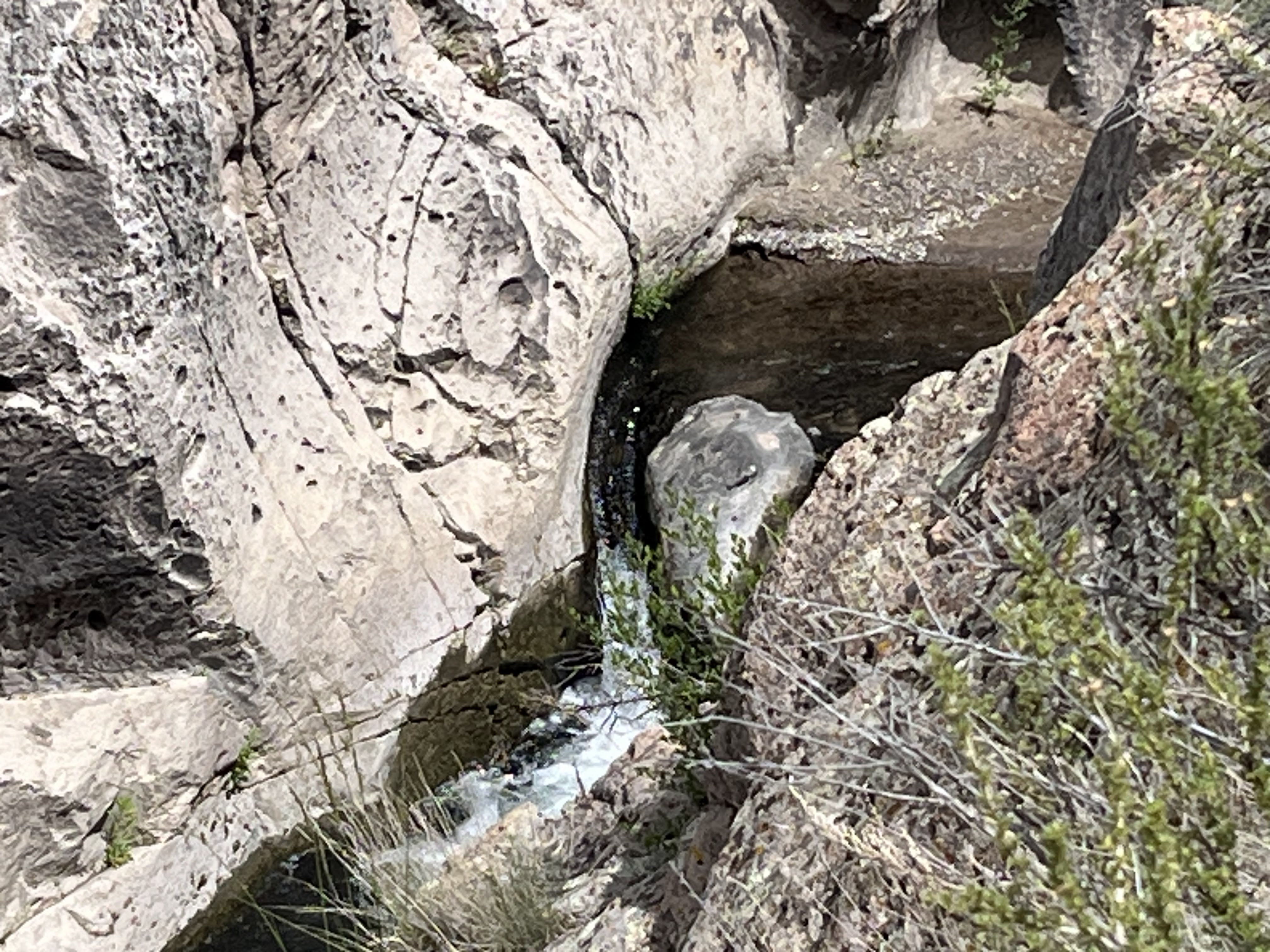
Narrow passage below a waterfall

We got up out of the canyon to look up at a maze of formations in front of us with absolutely no clear cut way to proceed. This whole little boondoggle reminded me once again of folly (sometimes) of letting  satellite images be my guide to unknown places. Google Earth images compress the verticality of any terrain and can't let me see through trees. Elevation changes of less than 25 feet can't really be discerned either and can be mighty inconvenient on the ground when confronted with a 15 foot drop-off in a canyon that's only six feet wide.

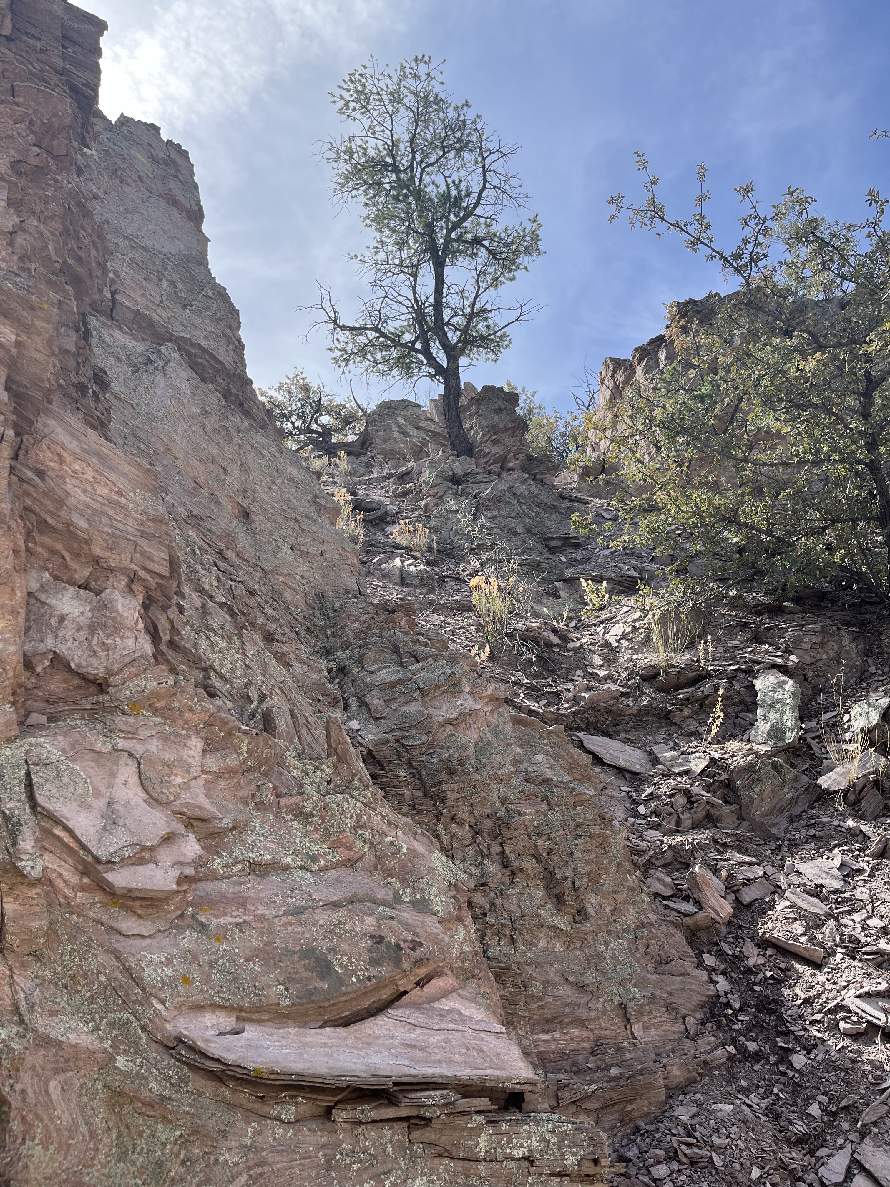
 The formations of white and orange were pretty cool though and we took our pictures and began our treacherous descent. I had a back up plan though. We drove a little further down Pierce Canyon, past where we had parked on our last trip out here  to where I had seen an old road following a side canyon.

Cool rock formations.
The kinder, gentler terrain of my back-up plan.

 The walking was pretty easy for little while, but when it started to get steep we retreated. I explored up another road that was barely there that appeared to go to a mining prospect, while my wife and the dogs stayed put in the shade of juniper. High on hill that seemed to be extraordinarily  proficient at growing agave, I realized  the mine tailings were farther away than I expected. I gave up and descended.  In the end the day amounted to a weird outing that was teetering on the edge but luckily didn't fall completely into disaster.

Agave

Labels: , , , ,

Monday, June 17, 2024

Apache (Gila) National Forest - Mangas Creek (San Antone Canyon)

Mangas Creek

JD Pit Tank

The spring


Church ruin at Mangas NM.

It was going to be another hot one, but I didn't want to hang around the cabin all day, so this ( what turned out to be) all day adventure to Mangas Creek and beyond ended up filling the daylight hours very nicely. We headed out from the cabin on Horse Mountain and after about a half hour turned off of NM 12 onto  Catron County Rd. A0 95. It's narrow, and once we started heading up and up out of the flatlands, a bit rough. It's also a very scenic drive as it follows the twist and turns of Patterson Canyon. At the top is a large meadow area where we drove past a couple of bicyclists on the road. We saw one camper at Valle Tio Vinces on this Thursday morning among the huge ponderosa pines. Soon after we pulled off onto the road that mostly parallels Mangas and then parked at a dispersed camping area.

 I could already feel the the warmth even at 8200 feet when we emerged from the car, but as began walking we were happy to see water as we passed JD Pit Tank. On the first half of this hike before reaching a second larger tank it was pretty easy to stay in the shade even though Mangas Creek is very much a wet meadow type of stream and similar to the many drainages of the Lincoln National Forest in that there are few trees growing in the middle of the canyon. There were many pale purple and variegated wild irises everywhere though. The very narrow actual watercourse, 1-3 feet wide in most places had no flow except a meager amount in a few short stretches but we could tell it had been flowing nicely earlier in the spring.

Aspens began showing up as we kept a slow pace up the trail-less canyon. It had been awhile since I had laid eyes on any and they were a sweet sight and kept our spirits up even as the heat of midday settled upon us. 

Approaching the second man-made pond (tank) the stream had a bit of flow in its channel and there were areas of saturated grass as well. Just past the tank we rested for a bit and ate some snacks. I was still hoping to get to at least the first of two springs that are indicated on maps. The problem was now the canyon was much wider and very open. We clung to the tree lined edges as best  we could but it was hot and the stream was completely dry now.

When we arrived at where the first spring should be, we had some difficulty at first finding it, but I eventually located it emerging from the dry hillside and flowing very weakly across the old road for  about 25 feet  before completely disappearing under and old fallen log. It was hard to even fill two small water bottles for my dogs for the hot return trip. We used the somewhat shaded road for the first leg of our return trip. At the larger tank where I wet my older scottie down, which gave him new life for the rest of the walk.

A couple of things I noticed about Mangas Creek. It is not currently being used by livestock and doesn't appear to have been for a while. The tanks were fenced, I believe, to keep straying cattle out while continuing to be a source of water for wildlife. The old road does not appear to get much use. 

We decided after getting back to the 4Runner that we would drive north instead of  going back the way we came. The road followed Mangas Creek in a more or less straight shot eventually passing the  forest service work center just before leaving  national forest lands. Shortly thereafter, we encountered a couple of tumbledown buildings next to two small ponds. Across the road was the stone and adobe ruin of a church. Further down the road an abandoned tin roofed house stood sat on a treeless hill. This is what remains of Mangas, NM.

Beyond Mangas were a few more very old stone and adobe buildings along the road with the more modern ranch houses and sheds back behind. Miles and miles of low rolling hills followed, populated with sagebrush, weeds and maybe a bit of grass. The only trees were tucked against the lonely ranch houses or shading a livestock first, via the South Pie Town Road, which is twenty miles of roller coaster country road, before turning onto the more reasonable Green Gap Road.

UPDATE (6/7/24): Within hours after we left Mangas Creek, a lightning strike on a nearby ridge started the Antone Fire.  It is being managed  for beneficial effects within a contained perimeter. Where we hiked is currently closed. The area may look quite different from what is pictured here.

Labels: , , , , , , ,

Wednesday, June 12, 2024

Gila National Forest - Tularosa River


The falls


Boxing up.


The road that took me back.


I had spied this little box section of the Tularosa River a while back  as a place where there was at least some chance of finding (and maybe catching) a few trout. This narrow 3/4 mile stretch is part of 1.75 miles of riverfront on national forest land which may be the longest public access to the river in its 25 or so mile run. It's got to be one of the prettiest.  Although when we visited the petroglyph site upstream from here last year, that was very nice as well.

 I parked off of FR 4161D near where it branches from 4161C after driving an hour and twenty minutes from my cabin on Horse Mountain. For some reason I completely missed the continuation of 4161C which was going to be my first leg of the trip, but I knew it was probably less than a 1/2 mile to my turn-off onto FR 4318V( which I had planned to walk anyway) so I just started hoofing down the wrinkled, rocky and grassy valley. At the power lines I started up hill to the top of the little ridge above the river, catching an elk peacefully grazing along the way. Now, I realized, it wasn't going to be all that quick or easy getting down to the stream. In fact, it was very steep and rocky and I took it very slow. At the bottom, just downstream of a big horseshoe bend in the creek and a section of private property, I found green grasses, and muddy springs  and a few inches of water in the wide river bed, as I walked along to the beginning of the box. When I came upon some in-stream boulders, I decided to get the fly rod out. 

Fishing began in here.
My Redington Butter stick lower right.

At first my cast yielded nothing, but as I went further down, where the stream confined and began rushing between the rocks, there started to be many approaches and almost defensive attempts to chomp at my dry fly at the many little pools that were a foot to two feet deep. This is how it went at several locations. I changed dry flies. I tried a couple of different nymphs but not one legitimate hook-up.

My expectations had been low for success, so even though I continued trying, I wasn't the least bit I  discouraged, especially since my surroundings became such wonderful place just to be. Rough-ribbed canyon walls of volcanic rock rose up with deciduous trees ( box elder, oak, walnut, cottonwood) clinging to their sides. Springs gushed forth from just off the stream bed lushly populating the sandy banks and high spots in the stream with the cress, grasses and even a few willows. Eventually I found myself picking my way through the boulders and little cascades until the stream was just running in a solid half-pipe of bedrock. 

Shortly thereafter I came to the top of a falls with very deep pool beneath. I could see plenty of fish both up close to the surface as well black forms down at the bottom. I couldn't say for sure any of them were trout, but I began casting anyway, with pretty much the same results I had been having. I tried going deep, but could never get anything on the bottom to even move. 

At the top of the falls.

When I got tired of trying, I had the impulse to just jump in, but I wasn't sure if there was going to be a way back up. I also really wanted to get a photo of the waterfall if it I ended having to turn around. So, first I tried the south side which was treacherous and brushy and didn't yield much of photo. Then I looked across. The north side was obviously the way to go and after the difficulty of getting back down to the stream, I hoisted myself up and had an easy walk down to the lower end of the pool that ran out from the falls.

The falls from up above on the south side.

 There were scads of little fish upstream from a homemade rock dam and they swirled and dashed away from my every step. They were definitely not trout. I believe these were loach minnows upon research conducted back at the cabin, but I'm not sure. These weren't the only kind of fish in there though. I tried some more casting into the deep, clear pool to no avail. I'm guessing some of the ones that approached my fly were chubs of one kind or another. The forms on the bottom were probably suckers. There may have  species of dace and shiners in there as well. 

Beyond this lower bedrock run the valley opened wide and the stream barely slid across the rock and through its own algae with just an inch or two of water in most places.

 I had my picnic under the shade of a pine. I wet my hat and shirt in the river. I found the road that would take me back. Along the way was a wooden shack and an old corral. 

Old shack near the road

    Scenic old corral and Jon S Mountain

    It was warm, but because of the thin layer of clouds that had been a constant since morning, it was never unpleasant. The road was quite drivable I discovered as hiked along, and I realized it must get some traffic just from people who want come down and use that pool below the falls as a swimming hole. 

Old restaurant sign found near the creek bottom.
Highway sign perhaps washed down in a flood.

Labels: , ,