Thursday, December 26, 2024

Magdalena Mountains, Cibola National Forest - South Baldy Trail (FT 11)

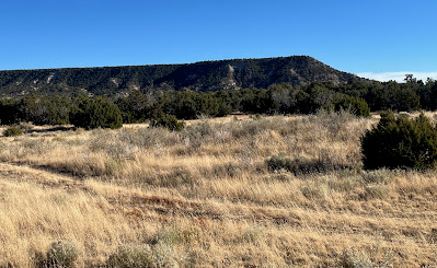
view to Water Canyon Mesa


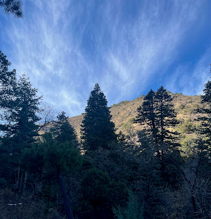
new growth of Doug-firs and a few spruces

large bent over Douglas-fir

old trail sign


 Stopping by while heading home from the cabin a couple of days before Thanksgiving, I did this little hike in the Magdalena Mountains. I only covered a steep 3/4 of a mile (one way) of the South Baldy Trail (FT 11), but that was enough. I started from lower trailhead along FR235. The narrowness of the canyon made the trip dark, cold and snow-covered most of the way until a switchback took me out of the canyon and onto the sunny chaparral hillside of a south facing ridge.

  Already sweating from the pace I chose and the 800 foot elevation gain in less than a mile, emerging onto the sun-baked hillside where it had too be close to 20 degrees warmer was the last thing  I wanted so I turned around.

 The trailsides are full of snags from many (mostly) Douglas-fir trees that thrived in the mesic environment ( the trail is kept clear though). There are new ones coming back in( plus a few spruces too!), but the tangle of downfall in the creek bottom is a bit ugly in all truthfulness. 

There is also plentiful box-elder which I've noticed seemed to have found a niche in the narrow stretches of other canyons in the Magdalenas. 

 Views are great looking back down the trail which definitely salvaged the whole excursion.

Labels:

Monday, December 16, 2024

Pueblo Ruins - New Mexico State Trust Lands


wall corner


This site is in far northern Catron County on NM State Trust Lands  pretty close to the one we visited last year. Another site that I haven't visited yet is very nearby, also on State Trust Land.  A site on private land where the walls are clearly visible on Google Earth is also close. Most likely they were all contemporaneously occupied. It was a windy day so the long drive from the cabin didn't seem to matter much. We would've probably been stuck inside anyway. The hike was short and the wind not particularly stiff while we explored.

sherds on an ant hill

 Sherds were everywhere again, as well as lithic debitage and fragments of stone tools. The  built-up rubble piles of mostly unshaped stone and the artifact scatter covered about 5 acres. I'm pretty sure I could make out the outlines of room blocks in the grass and thorny shrubs (which seemed to proliferate on disturbed land). There was also the corner of a wall (which I'm assuming is original) beneath a juniper.

large pestle fragment (I think)

On the way back we took the Saulsberry Road, that runs from US 60 to the Green Gap Road. It was a very nice backcountry drive, that meanders through Cibola National Forest, private ranches and State Trust Lands.

Labels: , ,

Monday, December 9, 2024

Sierra de las Uvas Wilderness - Wall

The wall

soapberry trees in the arroyo


 I spied this wall on Google Earth while looking for hiking route into the Uvas Mountains Wilderness from the northeast.  It piqued my curiosity right away, well, because man-made structures of any kind are not at all that common in the Sierra de las Uvas, and anything this substantial made with native rock, even less so. It would be a short hike from a well maintained road, so when I had little time one Sunday a few weeks, I went out.

 I parked right at the wilderness boundary and then off I went on sunny and warm autumn afternoon. I first approached it from above, walking along the stony ridge. My initial thoughts when seeing it in the satellite image was that it was a sheep pen or horse corral of some kind, but now looking at it in person, it seemed the space enclosed by it was too small to be of very much use.

 I circled down and around  and carefully climbed over a tumbled down section that sits on a slope on the south side. The intact part of the wall (which is most of it) was over 3 feet tall and made of dark volcanic rocks and boulders ranging, for the most part, from six inches to over two feet. Some boulders definitely looked too heavy for one lonely sheepherder or cowboy to move by themselves. 

The space inside was very limited as it was built very close to the cliff face behind which serves as  two of walls of the rectangle with the built wall approximating an "L" shape. The interior was very much on a slope as well which didn't seem particularly useful if bringing livestock inside. There was also no apparent opening to get in and out anywhere I could see, which really made wonder if this wall had any use for livestock at all.

 I climbed back and looked all around the immediate area for any kind of artifact laying around that might give my clue as to when it was built. Nothing. I even circled the area twice. I know that there are CCC erosion control projects nearby as well as a WW II bombing target, both of which may have something to do with this structure, but there was no obvious trail or road leading to it.

 I don't really know what it was for or when it was built. Folks who saw the images on Facebook all seemed to matter of factly decide it was for sheep. One even thought it might be a lambing pen. This may be the case, but I'm not so sure. As for the era, well, they were less sure about that, but I would think sometime before the widespread use of tin cans and glass bottles.