Wednesday, January 29, 2014

Organ Mountains-Desert Peaks National Monument - Pine Canyon Revisited, Sierra de las Uvas


Ah( sigh)... Pine Canyon. Despite its prosaic name, and because of its difficulty of access, it still remains a place of  mystery to me.When I first set out to explore it a dozen or so years ago, I was intrigued by the name itself, Could there possibly still be pines there? The top elevation of the Sierra de las Uvas is a little over 6600 feet. So there could be pinons, I thought, but would there be just a very few ponderosas in the most mesic canyons? Or  had the long ago namers of the canyon just lumped the many junipers in the area into  the pine family? That seemed the most  likely, but I had to find out. The hike was a long one: from a locked gate east of Massacre Peak to the  low saddle directly west of Magdalena Peak and then down into the canyon itself. Along the way I found  a petroglyph site by accident( see Apache Flat- Pine Canyon post in this blog). I did find a lone pinon in a drainage close to the top of the saddle.  And I have long held a vague recollection of seeing( but not photographing) a second petroglyph site down in the canyon.
        Ten years later I did a  hike to the plateau between Sugarloaf Peak and Magdalena Peak( Sierra de las Uvas post in this blog) and looked down into the canyon and the yearning was still there. Let me say right now that I don't recommend the route I took back then of going straight up Choases Canyon from the tank, and if I had known that was  the plan of my companions this past Sunday,( 1/26/14) I would have suggested something else. Also, I must let it be known that had I known that the hike hinged on my indistinct undocumented recollection of a dozen years ago about some petroglyphs in Pine Canyon- I would have suggested an alternate plan. But it seemed we were  all up for some adventure, so maybe in the end , it  didn't really matter.
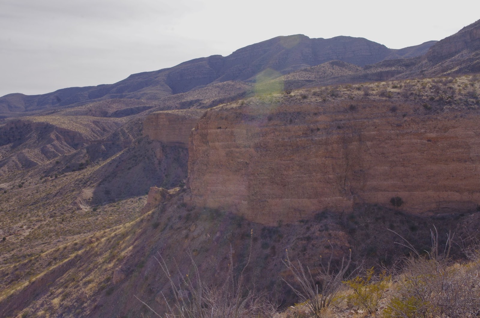
        The trudge up Choases was as I remember- rough.  Arriving at Kerr Tank via a very old road on the other side of the ridge, I walked  south up to the plateau on the good  cow trail from the tank, noticing that it had shoe prints on it this time. The others explored up Kerr Canyon. I had done a reasonably thorough job of this 3 years ago and was not interested. On top of the mesa we all looked  across Pine Canyon with its several winding tendrils at  the head that coalesce  to form the  main stream bed. The branches begin in a confined circle in the steepest part of the mountain range and the rest of the canyon is remarkable because it is so singular,  despite its size,with only a couple of short side canyons on the north side in these upper regions, and with Green Tree Canyon its main larger tributary coming in much further down along with a couple of smaller ones on the south side. In this way it is very different from the massive Broad Canyon system which dominates the east side of the Uvas.Be forewarned if you go: there is no good way down  to the bottom from here.  We thought about not going down, but only briefly before we split into two groups and proceeded via different  routes. Both were slow and treacherous. I found a fragment of  an old milk bottle on the way down- how it got there I'm sure is an interesting story that I'll never know. We proceeded farther down to a well. I wanted to check  the first of the two northern side canyons thinking it had familiar look and  some potential for  holding rock art. We were on our way when in short time we rousted a family of javelinas. I leashed Seamus the Scotttie. We  waited a while and I kept scanning distant boulders for petroglyphs but saw nothing.  A very small, very small javelina could be heard the entire time, and finally made an appearance. It was ridiculously cute and we all felt pangs  from putting it off of its mother who had run up the opposite bank.  Not wanting to risk an encounter with the adult javelinas, we knew that further exploration would have to wait.We turned and made our way very steeply back to the mesa top. We found several items of interest on the way back that we had walked right by earlier.
      We split into two groups again: one going around the mountain using the road from Kerr Tank, the other retracing our steps over the ridge and down Choases. We arrived nearly at the same time back at the truck. It had been a long, sun burned winter day. Yes, we had been in the canyon, but  it didn't seem like it, we hadn't found the rock art and I began to believe I  was mistaken and yet I couldn't be sure for even if I had been, the place was practically pulsating with it's beckoning and we had barely scratched the surface of its mystery. How and when we would return was anybody's guess.


Labels: ,

Thursday, January 23, 2014

Organ Mountains-Desert Peaks National Monument - Geronimo's Cave, Robledo Mountains


 I did this hike with my friend Eric on Sunday. The existence of this cave only came under my radar within the last few years, although it's obviously heavily visited as far unofficial trails in our region go. It got me thinking about all the ways I've found out about all the destinations I write about in this blog.  It's hasn't always been easy finding the places that I've read or heard about. Information is  incorrect or sketchy, names get confused, access is limited and even maps are sometimes wrong( see" Conkling's Cave" or " Souse Springs" in this blog). Happily, I had some reliable info about Geronimo's  Cave and had a very high degree of confidence that we would find it without any problem.
      We parked off the levee on the east side of the river. To my surprise, there was a small amount of water flowing now. I was still expecting it to be bone dry as with my previous two outings to the Robledos this winter. Crossing  wasn't much of  problem though. We wandered around amongst the thorny and not so thorny shrubs on the west bank  a bit, moseying over to the long mesa that extends from the cliffs all the way to the river. Along the way there were bits of pottery, colorful flakes of jasper,  and deer tracks in the mesquite anchored sand dunes. We made our way, steeply, onto the mesa and in no time had found a good trail and were at the entrance to the cave- a tall crack in the cliffs. I attached my headlamp, we began exploring. There are some formations in the cave, which are no longer growing.Most have been broken off or marred by graffiti. I noticed that the air quickly got warmer and a little stale the further back we went. At some point, perhaps fifty feet in, there is no longer any sunlight penetration. Off to my right was a narrow passage, that went on for  more than fifty feet.One skinny individual had made it back there to paint his( of course it was a male) initials. I was intrigued but didn't venture. Another passage was above us. My friend said that he had heard there was another cave above this one, and when we were back outside we explored the ledge to  the south  but found nothing except some graffiti left by"Antonio" back in 2002. What is going through the mind of someone who carries a  can of spray paint up the side of a mountain to mar a natural setting like this? I have a few ideas, but  I would like to hear some others.
      We  followed  a trail,marked with red ribbon, down the long ridge.  It was so peaceful atop that mesa and felt so remote even though the farms along the river and I-25 were just a stones throw away.  Eventually the trail took us down easy from the mesa top. We meandered a bit as we returned. I found a  beautiful basalt mano, my first, stuck in the side of an arroyo. We encountered  a woman looking for rocks in another arroyo. She had driven in from the river on her large ATV. In a short while we were back at the car, completing a nice hike on a beautiful winter day.

Labels: ,

Friday, January 3, 2014

Cedar Hills Highpoint ( Dark Mountain) - Organ Mountains Desert Peaks National Monument


I devised this hike last year after hiking in Buckle Bar Canyon on the east side of Rio Grande. From that vantage point,  looking west, I could see the three higher "peaks" of the Cedar Hills and thought they would make a good hiking destination.  The Cedar Hills are a continuation of the Rough and Ready Hills extending northeast in between the Robledo and Las Uvas  mountains. I planned my route many months ago, and decided to take the opportunity to give it a go this past Sunday( 12/29/13). I parked in a pullout near Broad Canyon Dam(on NM 85), went through the fence and hiked around the dam on the south side. We then descended  to the huge flats behind the dam and began following a two-track in the dried mud and sand. I was with Seamus the Scottie, who kept trying to investigate the brush along the edges of the road. As a result, he kept getting these inch long, egg shaped, nasty-looking, velcro burrs stuck in his fur. Some I could just pull off, but others got matted in quickly and I had to cut them out with the scissors on  my camping knife. In retrospect, I should have had him on the leash through this section. If you go with your pup, I advise you to do the same. We finally made it to the arroyo on the south side that we would be using and proceeded onward in the southwesterly direction. The little side canyon cuts through some very strange looking globular brown rock. There are many little alcoves in it as well. We had gone probably only 3/4 of a mile from Broad Canyon, when the cliffs rose up over 50 feet on either side and we were stopped by a 15 foot dry waterfall.


A few days earlier on a different hike( see Robledo Mountains- "Twin" Slot Canyons)  we had to turn around for one while going downstream, now our progress was blocked going up stream. Since there seemed to be no safe route to climb around it close at hand, we backtracked a short ways to a branch arroyo and began following it. Eventually we climbed up onto a wide plateau with three smaller peaks close at hand, and the obviously higher, larger peak( the Cedar Hills High Point) standing darkly a bit  further in the distance. We crossed a little "hanging valley" arroyo, which we could see spilled out  into  a huge boulder slide below us. We climbed up to another vantage point with fantastic views opening up to the east. We could see the Organs, the Dona Anas, the San Andres, the Robledos, Tonuco Peak and the Rio Grande Valley. Just below us was another boulder slide and a wide flat valley that appeared to be the headwaters for two larger arroyos that wound their way to the Rio Grande. We rested awhile, as I contemplated whether we had enough  daylight to climb the peak and make our return trip. It seemed too close at this point to turnaround.  We had some good luck nearly right away. We lit on a deer trail, which was like a highway compared to the cross country walking we'd been doing. It took us sidehilling around first one and then another of the smaller peaks and quickly had us at the base of the big peak. It was a steep little climb up to the top, but we did it in short order. There were two cairns at the top, but no caches or sign-in jars that I could find.


View to the Robledo Mountains.Organ Mountains are in the distance


 We enjoyed the views all around, but by the length of my shadow across the rocks, I knew we had to get going. I pondered the best way to go back and decided on the route that got me there. If only I could have stayed on it. Somehow I got in the wrong arroyo and ended up being blocked from going down by the same dry waterfall that I had encountered going in. Yike! We backtracked a ways and made our way slowly and safely around it. Then I realized two things in short order. I had left my dog's leash somewhere back on the trail and I was out of water. I'm definitely out of practice in the details.  Seamus stayed out of the burrs even without the leash. The sun had set when we got to the truck, but we were good. This was a great desert hike which could be made into loop via Coyote and Broad Canyons or  via the Cedar Hills Slot Canyon arroyo. Enjoy the photos of this beautiful place.         


Labels: ,

Wednesday, January 1, 2014

Robledo Mountains Wilderness - "Twin Slot Canyons"


 I devised this hike after seeing picture on Google Earth of a slot canyon on  the east side of the Robledos. The photo was taken by Les Mckee, whose hiking group likes to roam to out of the way places in the desert just like yours truly. One big difference, though, besides the fact that they travel in a large group and I'm usually alone or with one other person, is that they sometimes do their excursions in the summertime.I can tell by the greenery in the many wonderful photos that Les posts and  more obviously because the hikes are usually dated on the photo albums page.I can't say that  I recommend this. To me the desert is for late fall through early spring. My days of baking in the June heat and sidestepping rattlers warming in the morning sun are mostly, if not completely done. Anyway, the photo, which unlike some that Mr. Mckee posts on Google Earth, was right where it should be. Zooming in for closer inspection, I could see the tell-tale squiggly black line that indicates a slot canyon. In fact I could see two in close proximity to each other separated by a reasonably low ridge, which gave me the idea of going up one and coming down the other. 
Off we went on perfect, warm December afternoon. Access is from Valley Drive,then up on the levee road. We parked and made our way across the wide, sandy river bottom. On the other side we walked north on a old two track. At a long abandoned corral, we turned west toward the mountain. The canyons are directly below the " pass" between Robledo Peak and Lookout Mountain. The southern one trends directly east. While the north one flows in a more northeasterly direction. As we got close to the beginning of the south slot, we met a group of six or so people completing their hike. Unusual, as this place is definitely off the beaten track. Up we went into the dark,cool canyon passing by some gnarly old mesquite trees as we walked. This canyon is a bit wider than the one I wrote about a few weeks ago, so there is enough sun for plant growth. We saw hackberry, juniper, Fall's last wildflowers and the usual desert shrubs. The canyon is cut in the same rough conglomerate rock as the one in the Cedar Hills. There were several deep undercuts- which must be passed under. This was a little unnerving given the  friability of  the rock, but it's harder and more sturdy than it looks, otherwise there would be no slot.


There are some low drop-offs along the way as well, which can be easily scaled. Eventually, the canyon opens up to let the sun in, and then dead ends at high pour off where there are huge boulders and many old junipers growing. If only the second leg of our journey had been as pleasant as this first one.
      First problem: Getting up to the dividing ridge was not that easy, even though it wasn't particularly high. We tried one deer trail along one ravine only to realize that another deeper ravine stood between us and the saddle on the ridge. Trying the second ravine, there was no convenient deer trail,or lower degree slope, so we just ended up muscling our way up the very steep,slippery, gravelly slope. On top we could see a second high pour-off to the west. We made our way down to the bottom on a nice gradual grassy slope and all was good for awhile as we walked jauntily downstream,stepping over dead tarantulas and giving wide berth to a cave in the canyon wall.Second problem: we encountered an 8-10 foot drop-off. It was fairly easy for me to climb down. My wife then handed me our wary Scottie, and then she climbed down. I thought to myself that could be our last obstacle. No such luck. A short ways  further down we came to a 20 foot straight drop that could not be climbed down safely, and we certainly had no way of lowering our dog down even if we could. I walked up to the narrow fin of rock on my right side to see if we could go around the dry waterfall. Not possible. I looked down  on the last few twists of the slot and could see that in only a few hundred yards or so, the canyon opened up, turning into a wide desert wash. To be so close made the next decision all the more painful( of course when I thought about it later I realized there could have easily been one or even two more drop-offs like the one impeding us, there was just no way to tell).
     We turned around. We climbed back up to the dividing ridge. So far, so good. We thought briefly about walking out on the ridge itself,but with no way to know if we would get cliffed out, we decided to go back the way we came. Even though coming up to the ridge from the south side was hard, going down was downright treacherous. But down we went, rocks and gravel tumbling, sometimes scooting on our behinds until we  slowly made it  to the bottom. It was much more of an adventure than I had anticipated, but we made it back to the truck in good shape and it wasn't even completely dark yet. Topo maps can't really help you to prepare for these dry waterfalls. Their contours are at 20 feet and all it takes is a 12 foot drop off to stop you in your tracks. Google Earth doesn't yet have the resolution to see them either. So always be prepared to adapt and find a safe solution to any hiking dilemma.


Labels: ,