Tuesday, May 31, 2016

Hembrillo Canyon


This was a special trip arranged for field trip leaders for the 2016 ARARA ( American Rock Art Research Association) Conference which was held in Las Cruces on Memorial Day weekend. The sites visited are on White Sands Missile Range and are not usually open to the public.
 Hembrillo Canyon is a deep desert canyon in the San Andres Mountains. To the tops of adjacent peaks such as Kaylor and Treasure Mountains there is over 2000 feet of vertical relief. The canyon leads, from the east side of the range at a point almost 40 miles north of US 70, to Hembrillo Basin, the location of a battle between the US Calvary and Apaches led by Chief Victorio.  It is also the site of the famous( infamous?) Victorio Peak, where one of the west's most well known lost treasures is, or was said to  reside.  At the very least its legend was born  when a character named Doc Noss found a cave near its rocky cap. Whether  the treasure is still there, was secretly removed, or ever actually existed remained a controversy throughout the second half of the twentieth century and to some perhaps to this day.
Victorio Peak


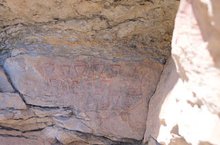
Our trip did not trifle with battles or treasure, but instead took us to two rock art sites along the road in the canyon bottom perhaps a mile apart or so. There were both pictographs in mostly red, but some black pigment, and incised images in the rock. The first site was referred to the as the Bloody Hands site and is in some overhangs in the rock along the north side of the arroyo. A few grind holes dotted nearby boulders as well.


  The second site is on some cliffs along the south side of the streambed where there are cottonwoods and grapevine at the remains of an old sheep ranch.There are two panels with large human figures, some much older spirals and geometrics, and one stunning panel of miniature animals.


While both places were certainly of interest. There just wasn't a lot of rock art at either location. We weren't really allowed to explore either. So itchy as I  always am for a hike, I ended up doing a lot of pacing up and down the sandy canyon.
 It seemed to me the canyon itself was the real prize here, with wildflowers growing from cracks in the cliffs, and steep mountainsides of layer after layer of sedimentary rock. I've been in the  San Andres Mountains three times now and it always seems like such a shame for the place to  be off limits. The mountains, canyons and desert springs are the real treasure of this place and I ruefully wished I was free to explore the many secrets and unknown beauties of this long and narrow range.

Labels: , ,

Wednesday, May 25, 2016

Wayland Canyon Trail( FT 433) - Lincoln National Forest


  I had wanted to hike this trail back in October,2014, but we couldn't find the exact locations of either the upper or  the lower trail heads. We knew where both should be, but when we looked for the lower trail head just off the Potato Canyon Road( FR 437), there were no signs, no cairns,  and no tread,just a brushy hillside of snags left from the Scott Able Fire. We found the remnants of  Forest Road 433,about six miles further along and 1500 feet higher, from which the trail should have started on the upper end, but it disappeared in the brush and snags as well.
 The information person at the Forest Service Office in Cloudcroft didn't have any information, so I put this hike  back on the shelf,but still remained curious.  Over a year and half later, with new directions from the updated entry for this trail from the  website (http://lincoln-nf-trails.org/Trails/Sacramento/S-main.htm ) run by Lynn Melton, we found our way to the upper trail without a hitch. It is now off of FR 434 which takes off from FR 437 in a rare patch of remnant  forest left on the ridge. In addition the lower trail head is signed and gated now,but is still an unattractive place to start a hike.

  We set off down the wide green vale, passing some mature stands of untouched aspen that grew in the canyon bottom. Both the north and south facing hillsides were burnt is this upper end, exposing cliffs of sandstone and limestone. There was very little growth of new conifers  even 15 years after the fire. Instead, there was low, barely leafing out gambel oak and the dreaded locust.  Clumps of what I think is a thorny currant species grow here and there as well, dotting the grassy valley and the lower hillsides. It would seem, looking at this picture, that the pine forest, or even an aspen forest is unlikely to return to this area.


 One of the reasons I was interested in this trail in the first place was that it was one of the very few in the Sacramento District of the Lincoln that permits foot and horse travel only. No bikes, motorcycles, or ATVs are allowed, and by the looks of it, this designation is being abided by. The only trail in the valley is an intermittent cow path. We did meet the cows and their  calves soon enough. I would have  preferred to walk around them,but they got the notion we were herding them down the canyon. We let them run awhile so we could hike in peace without having to listen to their constant bellowing. This looked like a sleek, well cared for, tamer group of cattle than we typically encounter in the Lincoln. We didn't have to stare down any false charges by some rangy cuss, which I've kind of gotten used to, but still appreciated the lack.Seamus, for his part, was alternately aggressive and afraid of the big and little bovines. He never quite knows what to make of them.

 As we continued down, the canyon sides were more well forested with douglas and white firs, ponderosa, and white pine. In the swales at the heads of little side ravines, stands of aspen grew.We passed one small spring that emerged on the north side,but I was somewhat surprised at how dry this canyon was: none of the little rills or seasonal springs had a trickle, especially when compared to the hike I did in Dark Canyon last year around this time. After eating, I decided that the lower spring, the one indicated on maps, would be our destination and turnaround point. The canyon began to narrow. There were larger, but still bare oaks. There was Rocky Mountain maple,but no bigtooth maple that I could see. We  found the spring, flowing in several rivulets, over its own tufa mound, starting about 50 feet up on the south side of the canyon. We found the cows again as well.


On the way back, we saw a herd of young elk weaving through the trees. Earlier in the day we had seen three shaggy deer bounding across valley into the brush and snags. Very early on, there had been a beautiful red and yellow headed tanager that had alit on a bush very close to us and I thought it was a promise of a magical day. Not quite, but it was still nice.
We drove back out using the Agua Chiquita Road( FR 64) which is one of the prettiest drives in southern New Mexico. It is also suitable for almost any vehicle up to the intersection with the Scott Able Road(FR 460).

Labels: , ,

Monday, May 16, 2016

China Draw, McGee Canyon( Sunman Site)


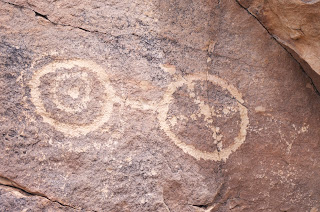
These two smaller rock art sites are in Luna County, north of Deming, close to the larger and more well known sites at  Pony Hills and Frying Pan Canyon. The China Draw Site is on a section of state trust land, a stone's throw away from the Hidden Valley Ranch RV resort, which is at the terminus of well-maintained county road, so I am sure it gets visited by  lots of people, yet on this past Sunday, David and Nancy Soules and myself were the only folks there, wandering among the sandstone outcrops and boulders, climbing on top of a few to see what we could discover. Lower down just up from the bank of the draw is a  dark gray rock covered with an assortment of  elaborate petroglyphs. Further up the hillside are  three orange and tan outcrops that are about 15 feet high. They are surrounded by numerous grinding mortars and have petroglyphs on every side and even on top. Many of the glyphs are similar in style those found at Pony Hills and Frying Pan, but as always there are few that seem unique to the site.   We explored the many outcrops, boulders and few cliffs, but it seemed that most of the art was concentrated in these two spots. I had begun to walk up to the higher cliffs, when I heard "the buzz" and quickly scoped out the thin neck and triangular head of a blacktail rattler in little hollow among the rocks. I turned back, so there could be a few more petroglyphs up high although I doubt it. I have been very close to this site on two different hikes over the years, and I've known of its existence for many years,  but for some reason never took the time to look at it. Given its ease of access,  and perhaps even without, it certainly exceeded all of our expectations.


We then headed, via a very rough and slow crossroad, with the mines of Fluorite Ridge visible to the north, over to the Greenleaf Mine Road( another well maintained county road). We drove northeast where we got  onto another very slow road just past Starvation Draw Dam # 2, stopping  at a point about a mile directly west of McGee Canyon. It is possible to halve that distance by using a different low maintenance road that also heads northeast from a point close to the east end of the Starvation Draw Dam # 1.
 McGee Canyon is a rocky little  defile on BLM land, that incises itself deeply into the ridge that is the western edge of Frying Pan Canyon. It  heads west for less than a mile before joining the much larger arroyo that is dammed by Starvation Draw Dam # 3. Coming at it from the west we crossed creosote flats, climbed a few mounds, eased  in and out a couple of large arroyos, and stepped over another road as well. It is not on maps as far as I can tell. Where it starts, I can't say. All the while we kept a line toward some cliffs that we took to be the entrance to the little canyon. At the mouth was a large juniper, and there were more further up the stream course as well. There was also the high dried grasses of last summer, and much scrub oak, which were further indicators that water lingers in this canyon and that it may even have seasonal springs. We all speculated that in times past perhaps China Draw and Starvation Draw themselves had, if not perennial flow, then extended seasons of surface flow. Which may explain why this place was attractive to ancient peoples.

 We found an old mine with blue-gray tailings that had hardened like cement, a " cave" made from 3 massive  boulders leaning against each other, grinding mortars, and of course many  petroglyphs.
 What we did not find was the icon for this site: the large Sunman, a humanoid with a  small head, large eyes and a rectangular spiral for a body.

 
We were a little pressed for time on this day, but this is really neat place so I feel that a  return trip in cooler weather is highly probable. On the hike back, the clouds that had been keeping us cool departed, and the temperatures rose to the predicted low 90's. The pleasant breeze turned into a steady west to east wind, that blew my sombrero off over and over. Happily, we didn't have all that far to go, and we all made it back to the truck in good shape.
 NOTE: The case could be made that the art at both of these sites is less abundant and perhaps lacks the craftsmanship, artistry and imagination that is so apparent at both Pony Hills and Frying Pan Canyon, but their proximity makes it easy to visit all four with  two  different hikes. China Draw can be seen by extending a visit to Pony Hills (or vice versa) perhaps just a little more than a mile, and very short loop hike could allow one to visit both Frying Pan and McGee Canyon.


Labels: ,