Mount Riley Wilderness - Cox Peak, Organ Mountains Desert Peaks National Monument
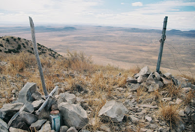
Cox peak is the tallest point in this cluster of massive mountains that are easily visible from the east mesa of Las Cruces. From that vantage point they look like islands rising out of the sea. It's hard to describe or photograph how huge and steep these mountains appear as you get close to them. They dwarf the nearby East and West Potrillo Mountains, like a block of skyscrapers smack dab in the middle of a suburban neighborhood. I hiked Friday on those steep slopes which are completely covered in broken rock. When hiking this mountain it's best to stay on the vegetated ridges even if it means dodging cactus and ocotillo. It's seems much safer than the bare talus slides (rock glaciers) that dominate nearly every available face of the mountain, although I've read at least one account of an individual using the talus slopes to gain the summit. From Gap tank on County Road A007, it took me about 2 hours to do the 2 mile (one way), 1500ft+ elevation gain climb and about 1 1/2 hours to get back down. Views are typically expansive, with ranges in Texas, Mexico, New Mexico and maybe even Arizona to be seen. On top there is a sign-in notebook in a jar. I was the first person to climb the summit this year. I saw numerous raptors, including a golden eagle. Jackrabbits and a few early bird lizards were out and about as well (which may explain the raptors presence). Access is actually fairly easy on County Roads taking either A005 or A008 and A0011 (I recommend these later 2 especially if in a 2WD passenger car) to A007 from New Mexico Highway 9. There are many other jeep trails in this area but the maintained county roads are signed and it's best to stay on them unless you have high clearance 4WD. The second spring I lived year we camped on an unmaintained road that runs up a canyon on the northeast side of Cox Peak. Cattle let us know their displeasure at our presence all night. We hiked the next day in the arroyo to the saddle between the major peaks, but it was almost too hot already even though it was only mid-March. I enjoyed my day here and have hikes planned for Mount Riley and the East Potrillo highpoint, but they may have to wait until the fall.
 |
| view to the East Potrillo Mountains |
 | |
| View to the West Potrillo and Florida Mountains |
Labels: hiking, Organ Mountains/Desert Peaks National Monument


