San Mateo Mountains, East Red Canyon (FT 31) - Cibola National Forest


In 2017 I went to the amazing and awesome box of East Red Canyon. In 2018 I visited the nearly as amazing and awesome box of Deep Canyon. It was hot both times, but I kept the hiking distances short. There was enough shade, so I didn't really ever feel uncomfortable.
I was hoping for some earlier rain this year to green up the place a bit, and perhaps bring down the temps before I ventured out. I kept going back and forth in my mind between going to Cold Spring Canyon Trail (FT 87) or the Indian Creek Trail ( FT 48). One had a much shorter drive, but a much tougher hike (Indian Creek). Cold Spring's trailhead was further away with the last dozen miles or so on forest roads that went from slow to slower to slowest, but, at least for the section I was planning on, the walking would be easy with only one major elevation change on the way in and out, whereas Indian Creek would have two climbs that appeared to be mostly without shade.
Thursday morning, I tossed out both, choosing to reserve them for cooler times of the year, and decided I was headed to a little canyon in between called The Gorge. I quickly figured out how to get reasonably close with various forest roads and then off I went. I was hoping just to get in a short ( the continuing heat was precluding anything over 5 miles roundtrip) morning hike to what appeared to be a rocky, deep, scenic and steep little canyon and get out and on my way, much like the previous two years' hikes.
Well, it got complicated. There was road closure sign at the beginning of FR 225 due to the Roberts Fire which had started five days earlier. Still, I drove on, hoping it didn't affect where I was headed. A local fire official in a white pickup was coming the other way a short time later. He seemed to think the closure was meant for the very road I was on, and told me I was going to run into the fire camp shortly. I did, and that's where I talked to two very nice forest service employees, who gave me the low down on the fire and the closure perimeter which handily eliminated all three of the options I had researched. We talked about a few options outside of the the perimeter, one of which was a place called The Park. I turned around and drove back out. When I got to NM 1, I decided to give this place The Park a shot. I headed north to NM 107 and then west on FR 378. FR 378 starts off okay up on the grassy mesa, but then heads down into a shallow arroyo ( Horse Mountain Canyon) where the going gets rougher as it crosses back and forth over the dry streambed. Once it leaves the creek, it gets significantly rougher and slower still, as it narrowly weaves along the hillside, plunging steeply in and out of side drainages. The seven or eight miles from the Tigner Ranch to Park Well took around 45 minutes. Now, I wasn't super happy about the fact it was already 10:30 and all I had been doing for the last three and a half hours was driving, but I was glad to finally arrive somewhere. The Park was large and level enough for a ball field and the closely cropped grass was just beginning to green up. Juniper and a couple of pines dotted the flats and rimmed the hillsides.


I got out. It was hot and just humid enough to feel a little unpleasant. I started following a rutted two track to the west. I was thinking it would curve around to the north to Exter Spring where it would dead end. I only found after my hike that there was another set of tracks going past the well curving west and then north like I had expected.
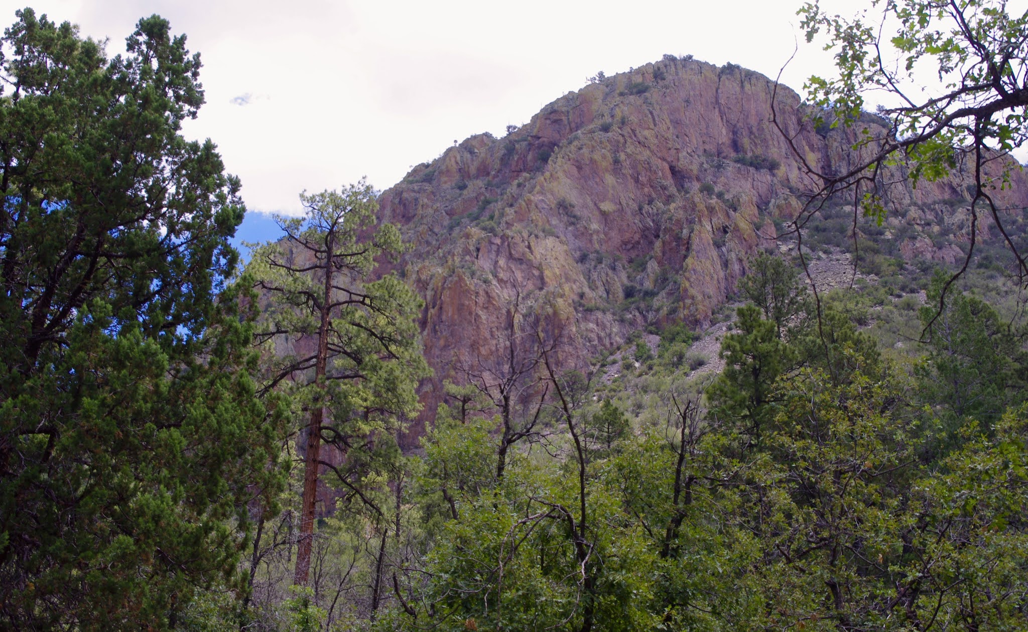
Well the rutted "road" turned into single track trail and began heading into a sizable canyon. I headed down. Junipers grew out of red dirt patched with well mowed (by bovine teeth) grass. I thought about going downstream first, but upstream there were red rock cliffs, pinnacles and fins, plus the massive southern rim of the Mount Withington section of the mountains rising above.


I headed up and eventually found remnants of a trail and well cut blazes. This is when I finally clued in (duh!) that I was in the upper reaches of East Red Canyon. I hadn't researched doing this trip, so I didn't know that East Red first curves to the north, and then to the west from where it's trail head is at the end FR 331 at Turkey Spring. I also was pretty sure that this trail( FT 31) was part of the closure order, but I wasn't heading straight back up the 300 feet I had just come down without seeing a little more of this canyon.

The canyon got very narrow as I continued on. There were oaks, chokecherry and other forest shrubs I see frequently in shaded areas but can't ever seem to get the names right. The lack of any real riparian trees told me that this canyon only flows very infrequently. Occasionally there were clumps of willows and I had seen some pieces of black rubber hose, so I checked my forest map and saw there were two springs in this reach of the canyon: Narrow Spring and Bear Spring. I found one but it wouldn't even qualify for moist, more like damp.
The walking was pretty easy for a couple of miles. The higher I went, there began to be firs and spruce in the canyon bottom as well as emerging from the scree slopes of the steep canyon sides. Bear and elk scat were here and there along the path. I kept telling myself as I went " just around this next corner, and I'll stop." I rested, I drank. I ate a plum, which wasn't a good idea because it puckered up my mouth which continued to feel relentlessly dry.

I hadn't eaten breakfast, but the thought of lunch, perhaps because of the heat, humidity and exertion, nauseated me. My anxiety was high. I wondered why I put myself directly into situations that are guaranteed to make it worse. Oftentimes it's hard for me enjoy the moment because of the worrying:"Will I get flat?, will I get caught in thunderstorm,? struck by lightning? Will I get attacked by a bear? Why am I always going to such remote areas?" etc. etc. etc..
Sometimes I think I just do things to have something to write about, because this time, sitting at the computer writing and looking through my photos which always look peaceful and never can convey the heat, sweat, dehydration, exhaustion and, yes, the anxiety, is alway good.
Eventually the trail headed northwest and I had to climb up a boulder strewn ravine. At a spot where it leveled off, below a rock tower, and the first aspens I had seen, I saw one more blaze in a stout oak, but I really couldn't find another nearby or any tread whatsoever. I had the idea at that point of making it to Lava Spring or New Lava Spring or even the dividing ridge to look down West Red Canyon, but I was too tired for any bushwhacking. I was probably less than a half mile from the top, but I also surmised there was still a lot of elevation to be gained. I turned around.
 |
| A few aspens where the trail turns to the north |
 |
| The last blaze before I turned around |
I hustled back, realized how much the trail had been uphill as I went back down with gravity on my side. Clouds had darkened the sky now. I heard distant thunder and very few drops landed on me, although I wouldn't have minded had there been a whole lot more. Climbing on the steep trail back up to The Park was a slow process due to frequent resting periods. I could smell smoke from the fire as I reached the top. I made it back to the blue, blue Tacoma and let that AC flow.
 |
| The Park |
NOTE: My apologies to the very helpful Forest Service personnel at the Magdalena Ranger District as I inadvertently ended up hiking on a trail that was part of the closure order. It was definitely not my intention.
Labels: camping., hiking, natural arches, scenic driving
posted by Devon Fletcher at
3:05 PM
![]()
![]()


0 Comments:
Post a Comment
Subscribe to Post Comments [Atom]
<< Home