Rincon Hills-Johnson Spring Arroyo and vicinity
We made two more trips out to the Rincon Hills over the last two weeks, which makes for a total of four this winter, trying to give this fascinating little area the same treatment I've given the equally overlooked ( as far as hiking goes) Selden Hills over the last few years.
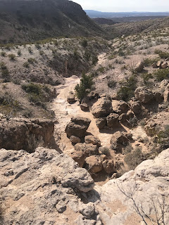
These two hikes both started from near the corral in Johnson Spring Arroyo. The last part of the drive is on an unmaintained dirt road that starts off crossing the rail tracks, going under I-25 and then mainly stays in the deep sand of the arroyo itself. The first trip Andrea, Seamus, Nessie and I branched off from the rest of our group (friends, Eric Luschei,David and Nancy Soules and their dog Hank), leaving the main canyon to go very roughly up to saddle and then around some of the higher peaks and down into a very narrow, hidden little box canyon, that is the canyon just to the south of the Falls Canyon I visited last month,
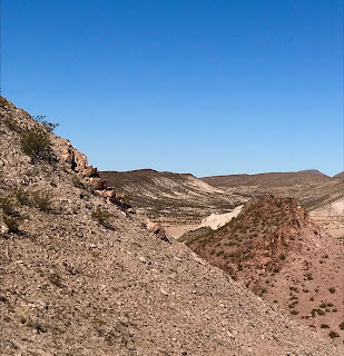
Along the way it was a bit difficult to manage our dogs who were more interested in pursuing cows, rabbits and couple of deer. The geology of this area, a complex mix of volcanic rocks, and sedimentary rocks derived from the volcanics, has a wide variation in colors and hardness. Reds, greens, purples, grays, pinks and even a blinding white are in the palette. Some crumble at the touch, while others are hard enough to form cliffs and fields of enormous boulders.
We all also noticed a wide array of nearly every kind of cryptocrystalline quartz: agates, jasper, chert, flint, chalcedony, with an equally wide variety of colors of both groundmass and inclusions, practically everywhere we looked. We also found barite and manganese veins near an old mine and a few bits of a turquoise colored material near another excavation. Rock collectors will love this area, but be careful, a prospector who lives in a trailer near the corral may have active claims marked by rock cairns or PVC pipes.
On the first trip, we had to overcome several small dry waterfalls, one in such a narrow and dark spot it still held water at the bottom, on our way up to the top of the mesa. We then circled around, catching sight of a big javelina dashing away at top speed as we went, and descended through boulders and past cliffs to re-join the main arroyo. All along, both our groups were searching for petroglyphs, but we found none.
As our group got back to the vehicles, we found out from the others after they had conversed with some of friendly locals that there was indeed rock art up the main arroyo. As it turns out we had just missed it by hundred feet or so.
On the second trip we ( just my friend David, Seamus and myself) headed right to where I speculated the petroglyphs would be. On the way we met couple returning, we chatted a bit and then the man said he recognized my Scottie Seamus by both appearance and name. I introduced myself as the author of the Southern New Mexico Explorer blog, and he indeed was a follower telling me it had led him on many adventures. It's always nice meet someone who reads my blog right where there should be: out exploring our public lands. This was the second or third time this has happened. Shortly after the encounter we were at the petroglyphs right where I thought they should be on a big broken boulder in the middle of the canyon. Unfortunately there wasn't many, and the few seem to be well known with visitors leaving behind campfires coals, broken glass and discarded cans, which is a bit worrisome.

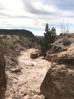
From there we marched up a rocky ravine similar to the little box from the previous week. It branched a couple of times and we stayed on the most traveled ( by cattle and wildlife) route.
 On top of the mesa we decided to circle back to the north so we could see the abrupt transition from the mesa to the main canyon. This vast upland flats of sandy and ashy soils with little more than regularly spaced creosote bush for vegetation extends for miles to the north, bounded by lower ridges of the Caballos and the collection of volcanic peaks called Point of Rocks. It's broken only by a few small ridges and shallow canyons draining to the Rincon Arroyo.
A spare few juniper trees both live and dead indicate the trio of sandy washes that turn into to rocky defiles, below three dry waterfalls. Somehow the crazy old road ( now a jeep adventure route) weaves through them in its steep descent to the big branch of Johnson Spring Arroyo. I inspected all three looking for rock art and perhaps grinding mortars ( the rock certainly was suitable), but found none.


 One did have a cave area that we found after plunging through the concealing bare hackberry trees. Some of it was low ceilinged, but part was perfectly suitable for getting in out of the wind, cold or heat for large group of humans. It had natural skylight/chimney opening which seemed to make it even more advantageous but we found no evidence that it was ever utilized.

 I went up above to see if I could see the opening from the top, but couldn't get to it safely.On the way I spied a rusty steel cable, attached to a rusty steel post with a gear on top. I wondered if they were either lowering down or winching up less than capable vehicles the very steepest part of the road through here. The cab of a Sanford and Son vintage Ford pick-up at the bottom of the hill, was, perhaps, evidence of a failed operation of this sort from long ago.
Labels: hiking, petroglyphs, rockhounding


1 Comments:
Three of us plan to explore Barbaras Tank in the Potrillos Tuesday and invite you to join us . I have a few map images I could send. I tried to attach but couldn’t. Rick Kelly 9157402500
Post a Comment
Subscribe to Post Comments [Atom]
<< Home