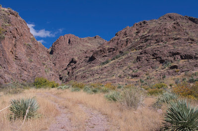
Mars(Cuates) Canyon- Organ Mountains Desert Peaks National Monument
I went on this little exploratory hike with David and Nancy Soules on Sunday. We started out from the Achenbach trailhead but headed out northeast, first in the arroyo then on a road. Along the way there is a ruin of a concrete structure now with only two walls standing. Nearby, there was an iron pipe sticking above the ground from a long abandoned well.
One of the fun things about this canyon was the abundance of New Mexico buckeye, a shrubby little deciduous tree with large seed pods, which isn't particularly common in most areas of the Organs. It gave the whole canyon a wonderful dash of desert fall color.

There is a trail of sorts once the road gives out, and then cairns here and there beyond where the tread is indistinguishable from the many other pathways on the canyon floor. We ended up high on the north hillside following one set of the little rock piles, but really this was a mistake as the footing was very treacherous on the numerous rockslides we encountered. David and Nancy and their dog Hank slowly backtracked to the stream bottom. I went a little further ahead, but then also ended up back down in the watercourse. Upstream from my landing spot, the canyon narrowed and was choked with vegetation. I had planned to hike all the way up to the ridge top at the back of the valley, but now that destination didn't seem all that interesting, at least not by this particular route. I turned around and had only taken a few steps when I was stopped by dry waterfall which had a genuine chockstone stuck in its narrow precipice. I probably could've climbed down carefully, but chose to go around steeply up and down on the north side. Back in the creek bed I came upon more cairns, and then quickly rejoined my friends.
We now made our way over to the best part of the hike: a narrow passage in the cliffs on the canyon's south side, which actually appeared to be the main source of ephemeral water for the lower canyon and gets the benefit of the blue dashed line on maps of the area. It became dark, cool and green, as we hiked up the stream bed. Past the hackberry, soapberry and buckeye trees, the canyon narrowed even more into what was essentially a long, high dry waterfall. We could see two "caves" up in the cliffs that were stained black from the years of summertime flows, which I would imagine would make this spot even more magical.


Across the way the cliffs presented themselves as significantly more imposing than I had given them credit for on the way up.


We lingered awhile. I climbed partway up the lowest part of the waterfall, and found a gully on the west side that could be easily taken up to the ridge. We contemplated the larger upper "cave" for sometime. From that vantage point it seemed an intriguing, if almost completely inaccessible destination. Looking back on our way out, it didn't appear to be a cave at all.
We investigated a few more little spots while returning on this November day that seemed just a trifle too hot and sunny for desert hiking.
NOTE: The first part of this hike is on private property that if all continue to treat it respectfully will remain as open access to this section of Organ Mountains Desert Peaks National Monument. UPDATE: Most of the private property that provides access for this hike and Achenbach Canyon has been acquired by the BLM.
Labels: hiking, Organ Mountains/Desert Peaks National Monument


4 Comments:
Devon, The Ocotillo Hikers discovered this canyon back in 2014 and spent several weekends clearing the tangled briers and vines that made the climb almost impossible.
Since that time we have enjoyed this trek countless times. Many times we turned left at the ridge line and continued along the Two Dog trail, returning to Soledad canyon. Occasionally, we would venture to the south, again following the Two Dog trail to the gate at Ft Bliss, returning following the main trail back to Soledad Parking area. A variation would be to continue south in order to connect with Ladera canyon. We would drop down into Ladera, then cross to the north to follow Achenbach canyon to the terminus.
Here is a link to Cuates Canyon as it is named on maps.
One of our group found out the canyon was owned by the Mars Candy heirs and started calling it Mar's Canyon.
Here is a link to one fo our hikes,
Les McKee llmcfog@aol.com
I knew you guys had been hiking there. I'm including it the guide book to OMDP National Monument that David Soules and I are writing.
Devon,
We have several hikes across the Rio Grande, only accessible during the "low water" months.
Some are spectacular, most are really pretty neat.
If you would like to see photos of these and others let me know.
Thanks,
Les
Deer Canyon is one we try and visit as often as we can.
https://photos.app.goo.gl/Qzh8EHFlKUGcXidB3
Another is Robledo Slot Canyon:
https://photos.app.goo.gl/sqQ5uPsVD6rHaM9C3
I have been to both of these. They are both in the book. My friend David just led a hike to the Robledo Slot Canyon. It wasn't quite low enough water yet. Everyone had to take their boots off and roll their pants up.
Post a Comment
Subscribe to Post Comments [Atom]
<< Home