Tilted Rock Canyons- Tonuco Uplift


Up and over the hill we went and down into the first of the two little boxy, slotty arroyos I wanted to explore. Both of them sit oddly perched on a mass of higher ground that extends out from the hills, surrounded by parallel arroyos that are much larger and deeper. At first there were few highlights as we walked down, but then I climbed up the low lip of the north side to peer down into a huge valley bordered by cliffs and eroded hillsides in shades of purple, orange, and red, with the massive Tonuco Peak looming just behind.


Soon after negotiating a small dry waterfall, we were in the narrowest part of our little red rock canyon which was cut through steeply tilted beds of mudstone, sandstone and pebbly conglomerate. It wasn't spectacular like iconic locations in our four corners states, but it was a fun and uniquely scenic location down here in the southern desert, that to my way of thinking could make a nice little state park someday.


At the bottom, I looked up the big wash on the north and then took opportunity to photograph the formations now in evidence on a larger scale that formed a rim around the sandy coalescence of several washes. I wanted to linger, but decided to keep marching on over to our second canyon and the return leg of our trip.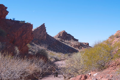


 We crossed over a low saddle among other tilted beds that were tan rather than brick red. We hiked around a dam and through the bunch grass behind it. At a large dry waterfall, I thought I spied some rock art and went to investigate. No luck. Now we were walking upstream in the second canyon, whose box section was rather short. At the very back, the very head of this little arroyo, we looked over the lip to another much larger valley that heads south and then turns east. Across from us was a purple hued mountain where there were some interesting looking cracks and crevices, but they would have to wait for another day. We made our way, always on the look out for signs of ancient peoples, but only finding abundant rocks of dark volcanic breccia at our feet, uneventfully back to the truck.
Note: This hike crosses state trust land and NMSU's Chihuahuan Desert Research Center land( technically also state, but on land ownership maps is designated No Trespassing).


At the bottom, I looked up the big wash on the north and then took opportunity to photograph the formations now in evidence on a larger scale that formed a rim around the sandy coalescence of several washes. I wanted to linger, but decided to keep marching on over to our second canyon and the return leg of our trip.


Note: This hike crosses state trust land and NMSU's Chihuahuan Desert Research Center land( technically also state, but on land ownership maps is designated No Trespassing).


Labels: hiking
posted by Devon Fletcher at
11:31 AM
![]()
![]()


0 Comments:
Post a Comment
Subscribe to Post Comments [Atom]
<< Home