Lincoln National Forest - Courtney Mine Trail (FT 132)


This hike fit the bill for a chance to get out with friends David and Nancy before they continued on to their property in Mayhill, similar to what we had done back in May when visiting South San Andres Canyon.


I've passed by the Courtney Mine Trail (FT 132) many times over the years on my way to other hikes further south on the West Side Road (FR 90), and since my friends were limited on time, the shorter driving distance (it's only 3 miles from US 82), and the short trail (about 4 miles round trip), this one made the most sense.
It was damp, overcast and cool when we started, perfect for the 300 foot climb to the ridgeline. The wide trail follows an old fence line, where the barbed wire has been removed but the posts still remain, through scruffy piñons and junipers. At the top views open up down into lower Karr Canyon with its houses and irrigated fields, and over to the forested hills of the Sacramento Rim.

We descended slightly more gradually than the ascent, with the trail a bit more trail-like in contrast to the straight shot up the west side. There were small oaks, white and ponderosa pines, and where the trail began level out a bit, an, amazing, gigantic hardwood ( broadleaf) tree, which I think could have been a cherry (or chokecherry). I couldn't get a good look at its live leaves that were all up high. It was not a maple or one of the usual oaks. It may have been an ash, or perhaps some non-native species escaped from cultivation from the farms and residential areas nearby. I really don't know. I may have to re-visit in fall. If anyone out there has an idea please let me know.UPDATE (7/31/22): I climbed up one of the branches to snag a leaf. It is a black cherry.

Further on was an open area where the fenced in Goat Ranch Spring is located. We could hear the water running in its concrete box, but nothing was filling a nearby trough, and there was no flow on the surface.
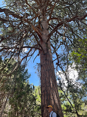
Nearby was another enormous tree, this one a ponderosa pine.


We hiked a bit further where to where the trail became more like a road as it crossed a drainage. I thought we were at Karr Canyon, and began looking for the trail to turn to the south. I found out later it was just a side canyon (tributary to Karr). My friends were running short on time so we turned around. The 400 foot climb of the east side was a bit of a lung buster, and the sun finally emerged just to add to the fun.
We parted ways, and then I decided to drive over to Karr Canyon to find the rest of the trail. I parked at the signed trail head and began a fast walk (without backpack) down the shady path which paralleled Forest Road 63. There was one large clearing early on, where an older couple sat sweetly in lawn chairs listening to music (at a reasonable volume), just enjoying being cool beneath the trees. As I motored on with maple and oak trees forming the trail canopy, I began to despair a little of how far it would be until I reached the point of the hike where we had turned around earlier, and that the trail was on a consistent downhill grade which meant all uphill on the way back. Soon after, the trail turned into an old road and now went uphill as it curved to the west. At last, I was at the earlier stopping point, and now had completed the trail.


 |
| Huge black cherry tree |
 |
| Very large pine near the spring |

Labels: fall colors, fossils, hiking
posted by Devon Fletcher at
1:00 PM
![]()
![]()


1 Comments:
Thanks for the description of this lesser known trail!
Post a Comment
Subscribe to Post Comments [Atom]
<< Home