Fresnal Canyon- Lincoln National Forest


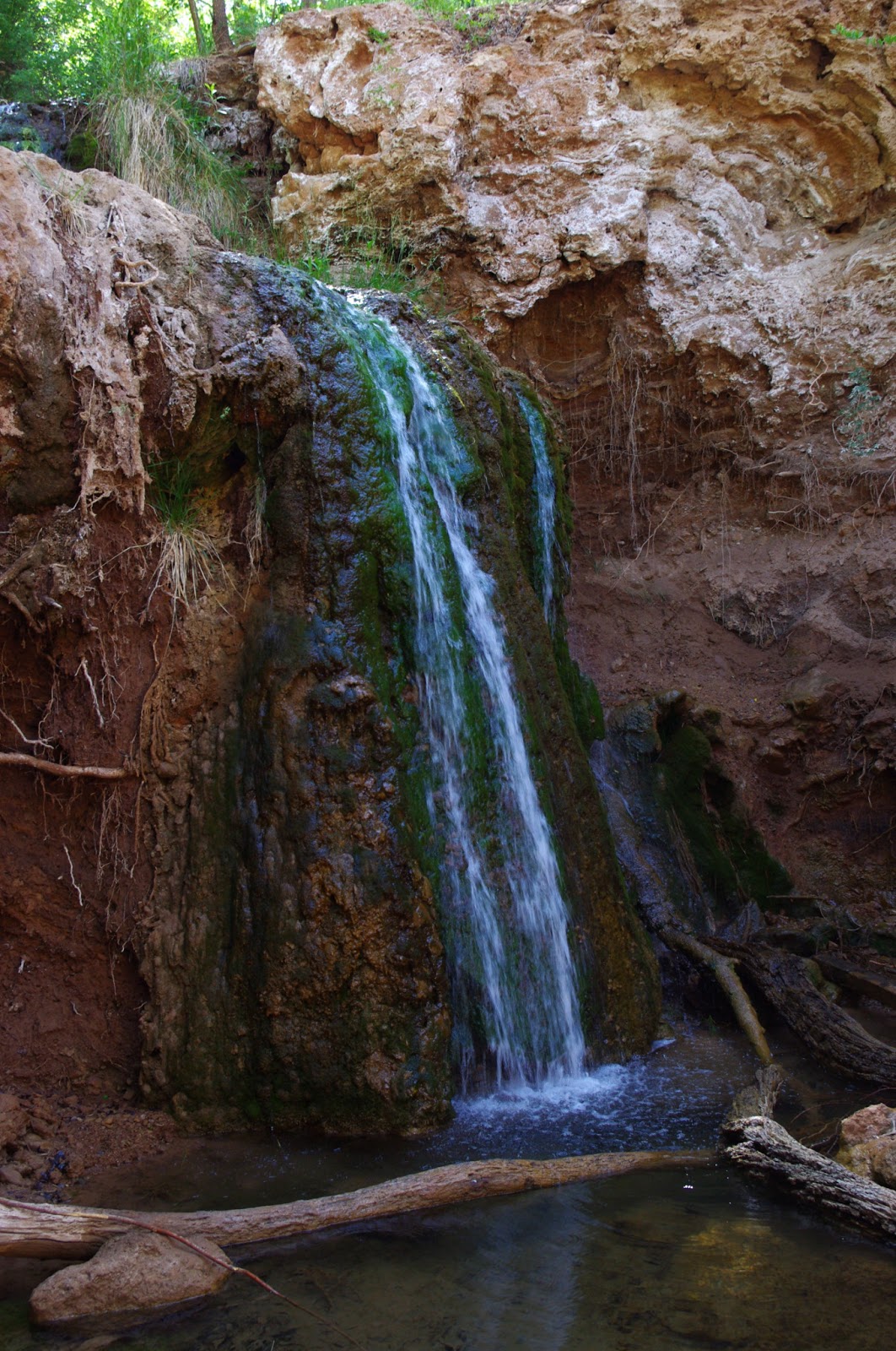
One quick slide on our backsides and we were in a different world. The water was flowing,clear and surprisingly strong given the extended drought we're in. At one of first trickling waterfalls, we were amazed at the depth of the pool beneath,but as we continued down past several good flowing springs, the waterfalls got higher and pools bigger and deeper. The largest one,below a thirty foot waterfall was probably 50 feet in diameter and easily over our heads. Down in this dark, narrow little canyon, densely shaded by its namesake ash trees, the creek runs cold. Canyon grape tangles are everywhere. Thick green moss grows on the limestone rocks in the cool of the canyon, while high above, immense cliffs of the same limestone bake in the summer sun.
We continued to be amazed with each new discovery( tiny travertine terraces, grotto like overhangs . . .), and scarcely noticed the not too shabby bushwack we were involved in to get to the bottom. Lower down, the stream leveled out into a peaceful, cottonwood shaded brook with the thorny, dry desert just a few steps from the banks. The length of our hike revealed an amazing oasis.This place would be a destination, and fiercely protected were it near a major southwestern population center( like Albuquerque or Tucson). El Paso is close,but in a different state. If this canyon were in Texas, I'm sure we would've needed a special permit and had to pay to get in there( as at Hueco Tanks). Since this place is barely acknowledged by the Lincoln National Forest or the City of Alamogordo, there is trouble in paradise.Fresnal Canyon's box is little too close to civilization and US 82 for its own good. Those big pools of cool water are magnet in this desert we live in , and in the section right below the Tunnel Vista parking there is ample evidence that people do visit this canyon to swim, and perhaps for other less innocent activities. Beer cans, blankets, and other forms of trash have been left behind. In addition, some feel the need to leave a more lasting residue of their time spent in the canyon: graffiti, some in garish neon colors, is plentiful on the cliffs and boulders in the choicest spots. It is mostly invisible from above, and likely to be seen by very few people. Truth be told, jarring as it was, it didn't have much effect on my experience. Still, it shouldn't be there and should be remedied somehow. More concerning were the few campfire rings we saw, not just because of the wildfire danger,but because people had actually started hacking away at live trees in pursuit of wood. It's strange to now to know this little jewel exists. I have taken a keen liking to it, and want to proceed to ensure it is not abused. Note: Some things have fallen or been washed into the canyon, not deliberately left behind. A partial list includes: tires, highway signs and the scattered but nearly complete remains of what we think was 40's or 50's era milk truck.


Labels: hiking, waterfalling
posted by Devon Fletcher at
9:23 PM
![]()
![]()


20 Comments:
What a gorgeous, hidden treasure of a place. The kind that inspires poetry.
I've caught many a trout in that canyon-- brown, brook, and rainbow.
Have caught many a trout in that canyon over the years -- brown, brook, and rainbow. The best sort of fly-fishing is the most solitary. For most fishermen it is unusual to be completely alone, and so the solitude you get at Fresnal is all the more unusual because of the busy highway not too far above you. NMG&F has spent far more on the trout "fisheries" on Burns Lake and the NMSU campus pond. Well, who knows, maybe one day NMG&F will pay enough attention to it to poison it.
We just looked at the fish. They all were rainbows. We were hoping to see a brookie or brown. I'd been down there once before,but it was flooding and not fishable. I haven't made up my mind whether to go back and fish it or not. Speaking of solitude- in my 13 years of fishing in New Mexico and Arizona. I have encountered a total of 6 other fishermen on the stream. It gets to be habit( the solitary excursion). I can't really explain to more sociable fishers. I fished with a friend once on the Penasco. I enjoyed it,but never felt much like doing it again.
My husband and I live in Carlsbad (he's a ranger at the Caverns) and would love to see this. Is there a hiking trail that leads here? If you could send me some more info that would be awesome. Kmason1186@gmail.com -Thanks!
Hi Devon,
I am driving through New Mexico this week and would really love to see this spot, but from your post I'm unable to decipher how I would reach it. If you could perhaps send me an email at seanccollier@gmail.com to help me get there I would very much appreciate it.
Thanks!
Just moved to the area. would really like to see this area. if you could email some more info on how to get there that would be great pcooksey19@gmail.com
For those of you wondering where to find this canyon, starting in Alamogordo follow the bypass 70/82/54 or White Sands Blvd to the red light on the north side of town and take 82 up the mountain towards Cloudcroft. As you start up the mountain you will come to a tunnel with a parking area on the left, stop there. There is a trail at the parking lot (pretty difficult) and there is one further up towards the tunnel that is a little easier. Just remember to carry water cause the hike back up is a doozy.
This is a tough hike back up especially if you get lost like me, the hike through the stream is awesome. I recently went to this area to do some fishing and i got my self a 6 inch rainbow trout the water is very clear, I saw a few other fish nothing over 6 inches, this is a hidden gem and thanks for posting this.
Thanks. We saw a few rainbows in the 9-12 inch range. We did the hike as shuttle leaving a car down at the bottom just off 162C.We had started 1/2 mile east of the tunnel. Hiking back the way we came was not really an option,nor was walking through the tunnel a good idea.
Really like your blog! Do you remember where the milk truck was? I am interested in taking some pics. Devon - can you e-mail me sometime? gobigredsox@gmail.com Thanks
This comment has been removed by the author.
A buddy and I went down from the tunnel in the summer of 1983 while we were stationed at Holloman. I'm not sure about a milk truck, but we passed what we thought were hundreds of beer bottles ranging from shattered to completely intact, sealed and full. There were also several pieces of wreckage in various sizes and mechanical parts which we took to be from a beer truck. There was no graffiti in the area and very little evidence of other visitors at that time, although it was relatively well known in the Holloman community. I think folks were just more responsible back then compared to today. I just discovered this blog the other day and love it. It's making me homesick for my 1st home away from home and bringing back tons of great memories. I also got a copy of your OMDP book and am enjoying it greatly too. I look forward to more and hope the pictorial book you mentioned in the PBS interview earlier this year work out.
Thanks so much Mark.
Summer floods usually wash most of the lighter items out of there each year. There's no official trail fo this canyon, and really the forest service would rather that people not go down there at all, especially if they use the steep hillside from the Tunnel Vista parking area. Eventually the stream hits private property a short ways before crossing Fresnal Canyon Road ( FR 162C or County Rd. A-60)
Hi Devon, hope you are well. Thank you for sharing this! I wasn’t able to find much info on the trail leading up to the waterfall, if you can share more information on the location of the waterfall that would be great! My email is huangn16@gmail.com thank you!
Many of the fish are actually cutbows. Cutts of some species were stocked in that creek in the late 1800's thru early 1900s. I have local stocking report articles. They were called spotted trout at the time.
Nice to know. Thanks for the information, Brian.
How far is the hike to the waterfall
From the bottom end, it's not too hard and not too far. Somewhere between 1 and 1.5 miles. From the top on the east side of the tunnel, starting at the red house, it's a pretty rough trip, but probably less than a mile. Most people just "hike" down from the pull-out parking near the tunnel, but I strongly, strongly discourage( and so does the Forest Service) anyone from doing that for several reasons.
Post a Comment
Subscribe to Post Comments [Atom]
<< Home