 |
A section of wall mostly likely reconstructed by some later visitor
|
 |
| Pack rat nest on the ruins |
 |
| Monkey's paw |
Left the house at 9:45. Began walking down FR 458Y to the site at about 1:15. You do the math.The road is actually pretty good, better than the one (FR 458) that brought us in, so we could have driven about 3/4 of mile closer, but it was certainly nice to get out of the car and begin walking among the piñons and junipers. It was a sunny 70 degrees so it felt warm, but light spring breezes kept things comfortable. The scotties ran and ran at first, but then began to take shade breaks as we negotiated the gullies that come down from the little hill we were climbing up to reach the ruins (the site might be more appropriately call the Pueblito de la Mesita given the diminutive sizes of both).

The vast Mesa de los Jumanos is very flat. A few ridges and prominences break the monotony but the blanket of mature junipers and piñons that cover thousands of acres block any view of what few landmarks there are. Even as we approached it we only got a couple of glimpses of the mesa, and from where we parked we could not see it at all, so I was grateful for finding the carsonite FR 458Y sign on the ground to reassure me we were on the right path. That being said, we had to only come up about half of the mesa's meager 200 foot rise for the views to the east and southeast open up for miles and miles.

We began finding pottery in the rusty dirt early on. As we zig-zagged our way higher up, we found more and more. Towards the top began the tiers of a pale limestone and sandstone bedrock, like a set of steps for our convenience. When we arrived the views opened up in nearly every direction save for the southwest due the forested southern half of the mesa.


 |
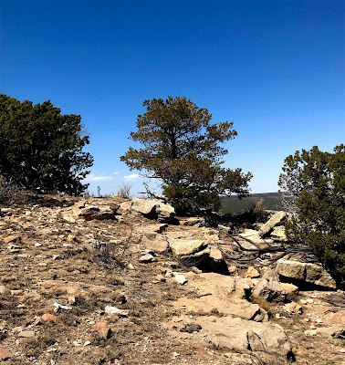
| Scattered rubble on the mesa |
 |
| views to the north of Mesa de los Jumanos |
 |
| Gallinas Mountains in the distance |
The pueblo is much smaller than Tabira (Pueblo Blanco) or Pueblo Colorado (which we could see from the top), but by the amount of rubble present, it seems that it had to have had multiple stories.

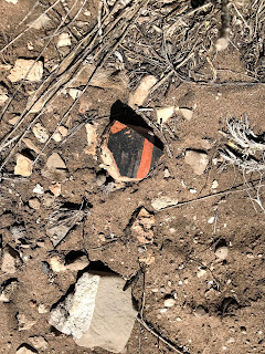
It was pretty easy to walk around the whole thing several times while we were up there, examining the mix of pottery sherds. Black on red, black on gray, black on white were the most common, but there was also buff, black and yellow corrugated plus some plain browns and reds. Andrea found a piece that may have been a handle or even part of figure, I dubbed it the "monkey's paw."
 |
| Mounds of rubble |
 |
| sherds |
 |
| sherd |
 |
| sherd |
 |
| Monkey's paw |
I also found the tiniest arrowhead ( projectile point) I have ever seen. It was only about a half to three quarters of an inch in length, and I later learned it's called a bird point although it was not necessarily only used for killing small prey.
 |
| corrugated sherd and bird point |
We had our picnic under a juniper and before we went back down examined the large holes on south side of the pueblo outside of a curving perimeter wall. Were they indicators of earlier occupation?, or areas where the rock for building had been quarried?, or maybe cisterns dug to store precious water? We didn't know and if you do please let me know.


We found more sherds as we descended and had a warm (the breezes had mostly stopped) uneventful walk back to the 4Runner, noting the many scat varieties (deer, elk, coyote, bear, etc.) as we went. A wonderfully peaceful place on a Friday afternoon, I suspect it receives few visitors, even from the local area. Given the condition of FR 458, I wouldn't have felt good about bring our little trailer, but as we drove off, I wistfully wished we had come with the tent to camp for the night.
My deep sadness for the loss of a close friend only a week before continued, but visiting this place lightened my burden a bit when I thought of the enjoyment he would've gotten from it.
NOTE: There was paper sign in a plastic sheet that indicated that this site is monitored TCAS, which I later looked up and stands for the Torrance County Archaeological Society. As always, I only photograph artifacts and do not collect them which is not only illegal but just plain wrong.
 |
Manzano Mountains in the far distance.
|
Labels: archaeology, camping, hiking


3 Comments:
It's so helpful when you caption the photos, otherwise I'm not always sure what I'm looking at. Thank you, as always, for this blog.
Thank you for the wonderful account of your journey! I am a New Mexico native, and now I live in Tularosa. I would love to explore the area. I found FR 458. Where did you park? Was it at the intersection with B6? I would really appreciate any additional guidance you could provide. I love the pictures! Thank you for reminding everyone NOT to pilfer these historic treasures!
I don't recall any B6, but we parked at the intersection of 458 and 458Y as I described in the blog. There are two other pueblos out there: Tabira, and Pueblo Colorado. Both are a little tricky to find. It's best to have some sort of app. like On-X or know what you are looking for on Google Earth. This one on the little mesa is the easiest of the three to find. The ruins are actually marked on Topo maps so they appear on most databases.
Post a Comment
Subscribe to Post Comments [Atom]
<< Home