Organ Mountains-Desert Peaks National Monument - Porcupine Tank
 |
| I believe this a tuff cone |
Started from a pullout at Foster Canyon on a windy Black Friday afternoon. I had thought about reaching Porcupine Tank by beginning at the Slot Canyon, but I didn't feel like seeing all the people that were sure to be there. This route route ensured solitude.
Going cross country over low hills at first, I eventually hit the arroyo that I had planned to use to take me up to a low saddle and then head down to Porcupine Tank ( I did do this on the way back). Only I got sidetracked, as I sometimes do, and headed up to the base of some cliffs to do some exploring. I found a few small prospects ( what they were looking for I don't know) and then decided to get up on top of the little butte itself which was dotted with dwarfish junipers and lo and behold had an old road coming to its conclusion.
I walked down it a ways and then came to another road off to my left, which I proceeded to walk down to the large Porcupine Tank, waterless, but still with green grass in its bottom.
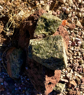
I explored around and below the tank before heading out towards an old dam I had seen when I had been up high. Along the way I found a very faint road that led right to it. I also found some odd looking green rock which I believe to be serpentinite ( but if any of you out there know better let me know). It seems the area just west of the tank is the location of a diatreme, a sort of volcanic pipe that is formed as magma comes explosively into contact with groundwater, which is what happened millions of years ago at this spot. Some unusual rocks can be brought up from the deeper in the crust, or even from the mantle, when this happens, or can be formed by the contact metamorphism with the sedimentary rock the eruption is passing through. Maars, like the well-known Kilbourne Hole, and several others located in the vicinity of the East and West Potrillo Mountains, are a type of diatreme.

I admired the handiwork of the dam and then was heading back. This was a pretty hike, but the trail-less walking for much of it was very rough. It probably didn't help that I was going at breakneck ( for me ) speed. I wouldn't do this particular route a second time if I decided to revisit this scenic area. The road coming in from the east may offer some possibilities, and there is always the route going through the Slot Canyon and continuing west if it's some random weekday.
Labels: backpacking, geology, hiking, Organ Mountains/Desert Peaks National Monument, rockhounding


0 Comments:
Post a Comment
Subscribe to Post Comments [Atom]
<< Home