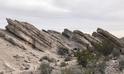
Thurman Sandstone, East Whitethorn Canyons- Rincon Hills
Earlier in the winter I had planned to do a loop through the north end of the Rincon Hills using the little box canyon I dubbed Whitethorn and another little box just to the southeast. Well, we didn't make it to the canyon to the southeast, so I returned to have look on Sunday (3/1/20). I parked about a 1/4 mile back from the corral in Johnson Spring Arroyo, and began crossing a fascinating expanse of tilted beds of bone white rock known as the Thurman Sandstone. This area covers a couple of hundred acres and is cut through by three main arroyos and a maze of a smaller tributaries. Although it wasn't my destination. it was the highlight of our little 5 mile hike that day. I could see definitely returning to explore this area more fully.


East Whitethorn was lined in its lower end by its ( now) namesake trees. It soon boxed up with red and then black volcanic cliffs. In the bedrock of the streambed, the vesicular basalt had numerous inclusions of green and blue minerals. I'd be curious to see if some of it is actually turquoise. We stayed to the right through the narrowest passages and then crossed over a small hill to the alternate branch.

The wind had been really blowing on the mesa we crossed to get to the canyon, so now for the return we used one of the arroyos cut through sandstone, in hopes of at least being partially sheltered from the blowing. We wandered down stream and eventually found our footprints from earlier in the day. Seamus chased a jackrabbit, that was so big, I at first thought it was small deer.
We followed our route through the brown gravels thickened with black sands, and over the bleached hills studded with loose red-brown rocks. How they arrived to provide the contrast in certain spots, I do not know.


We followed our route through the brown gravels thickened with black sands, and over the bleached hills studded with loose red-brown rocks. How they arrived to provide the contrast in certain spots, I do not know.


Labels: hiking, rockhounding


3 Comments:
Interesting place, would love to check it out. How do you get to it ?
Thanks,
Jean-Claude
Jean Claude, from the Rincon exit on 25 drive approximately 1.3 miles through town to NM 154, stay right and drive around 2.3 miles then turn right to cross the railroad tracks drive about a mile ( going under I 25 and opening a gate along the way) then bear left down into the arroyo.Drive in the arroyo for another 1.3 miles or so to get to where I parked. The sand is pretty deep, so you may need 4 wheel drive. The area is easily visible on google earth as very white patch of earth about 3.5 miles northwest of Rincon.
AAre there any other directions? I attempted to follow yours and was unsuccessful. Please email to my personal email your help. stlotkin@yahoo.com
Post a Comment
Subscribe to Post Comments [Atom]
<< Home