Basin Tank Escarpment- Broad Canyon Wilderness,Organ Mountains Desert Peaks National Monument
 |
| David Soules |
The Basin Tank Escarpment is the rugged transition area from the highland areas of Bell Top, Tailholt Mountain, and the high ridge east of Valles Canyon down to the arroyos and washes that collect and flow towards Broad Canyon. The environs near the tank that are almost completely devoid of vegetaion told us the area has obviously had a long history of overgrazing and erosion. The check dams we found, made of volcanic rock, that were perhaps built during the CCC era in an eventually unsuccessful attempt to help combat these problems were further evidence.
Seamus and I first headed up and into a huge field of dark volcanic boulders while David explored some steep canyons. After Seamus spotted some javelinas, but did not chase, I leashed him up temporarily. We then met up with David and all made our way down a canyon that I thought could hold water and perhaps rock art or grinding mortars, but found none. We headed further west over a low saddle and then began exploring up a very rugged canyon which did hold water among it's huge orange boulders. Above the rock fall, the canyon took on mellower aspect surrounded by grasslands punctuated with sparse juniper and low live oak. Above us were many alcoves. David explored one of the larger ones but it held no evidence of human use.


Before we departed, we explored a short distance up one more canyon close to where we parked and then we were off. It had been long day. There was one more canyon I wanted to see, but the darkness was coming fast.
I returned a few days later to explore that last remaining canyon. Directly above a dry waterfall that I had to backtrack and climb around, I found a couple of grinding mortars.

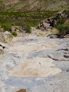
All along the upper canyon were pools carved in the gray bedrock that held water from the rains 5 days previous. Some were over 2 feet deep, a situation that surprised Seamus when he got into one to take drink. We continued up and up to the top of the mesa that overlooks Broad Canyon to the east. I wandered around a bit on a bench below the rim, and then made my way down into Broad Canyon to head back to my vehicle and complete my loop. Afterwards I drove down to the corrals near Hersey Place where Broad Canyon cuts through an obvious dike of of harder volcanic rock. I climbed up top to look around for evidence of the spring that once flowed just downstream from here but could see none. The windmill at the corrals, however, is still putting out water here and Seamus got in the disgusting pool to make sure he would be nice and filthy when he got back in the car.
UPDATE: In April (2017), I explored the top end of the canyon that David and I went a short distance up. This time I came around from Broad Canyon using a combination of canyons, cross country and an almost vanished road that begins across from Silva Springs Canyon. The upper stream course had a lot of bedrock, boulders, and cuts through a layer of basalt. It also had one large and several smaller dry waterfalls, some good sized junipers and huge octotillo just beginning to bloom. What it didn't have was rock art or grinding mortars, although there were a few of both in Broad Canyon and the small side canyon I used to access the mesa.
NOTE:After leaving the county roads E006 and E006A, the road down into Broad Canyon is in very poor condition. Beyond a boulder strewn crossing of Broad Canyon, the road to Basin Tank is rapidly moving toward oblivion. UPDATE: The road to Basin Tank is now within the Broad Canyon Wilderness. The road to the windmill at Hersey Place, however, is cherry- stemmed out.
I returned a few days later to explore that last remaining canyon. Directly above a dry waterfall that I had to backtrack and climb around, I found a couple of grinding mortars.

All along the upper canyon were pools carved in the gray bedrock that held water from the rains 5 days previous. Some were over 2 feet deep, a situation that surprised Seamus when he got into one to take drink. We continued up and up to the top of the mesa that overlooks Broad Canyon to the east. I wandered around a bit on a bench below the rim, and then made my way down into Broad Canyon to head back to my vehicle and complete my loop. Afterwards I drove down to the corrals near Hersey Place where Broad Canyon cuts through an obvious dike of of harder volcanic rock. I climbed up top to look around for evidence of the spring that once flowed just downstream from here but could see none. The windmill at the corrals, however, is still putting out water here and Seamus got in the disgusting pool to make sure he would be nice and filthy when he got back in the car.
UPDATE: In April (2017), I explored the top end of the canyon that David and I went a short distance up. This time I came around from Broad Canyon using a combination of canyons, cross country and an almost vanished road that begins across from Silva Springs Canyon. The upper stream course had a lot of bedrock, boulders, and cuts through a layer of basalt. It also had one large and several smaller dry waterfalls, some good sized junipers and huge octotillo just beginning to bloom. What it didn't have was rock art or grinding mortars, although there were a few of both in Broad Canyon and the small side canyon I used to access the mesa.
NOTE:After leaving the county roads E006 and E006A, the road down into Broad Canyon is in very poor condition. Beyond a boulder strewn crossing of Broad Canyon, the road to Basin Tank is rapidly moving toward oblivion. UPDATE: The road to Basin Tank is now within the Broad Canyon Wilderness. The road to the windmill at Hersey Place, however, is cherry- stemmed out.
Labels: hiking, Organ Mountains/Desert Peaks National Monument


0 Comments:
Post a Comment
Subscribe to Post Comments [Atom]
<< Home