Rocotillo Box Canyons-Prehistoric Trackways National Monument
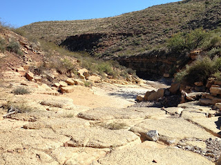
These two canyons( North and South Rocotillo) were once a part of the annual Chile Challenge rock crawling( with heavily modified Jeeps and such) event, but now,since National Monument designation in 2009, are more of a destination for quieter recreation. I parked about a mile west of the trailhead for the Discovery Site. I probably would've gotten a little closer still but for a washout that I didn't want to try. From the car I headed southwest on the road and then south walking out onto an “ arm” that juts toward the confluence of the two canyons. I discovered a rough" trail " back in the summer that took me down to the confluence. Saturday, I met a quail hunter named Josh at the bottom, who was surprised to be meeting someone in the canyon. We talked for a bit and then went on our separate ways. I then headed upstream in the canyon on the left ( south canyon). In the late summer there was water running over the limestone bedrock cascades and the usually dry falls about 1/4 mile from the fork was dripping as well.
The reason it’s best to start this loop in the south canyon is
these sheer falls are more easily climbed up than down. I had no trouble but if you want to bypass
the scramble, you will have to backtrack and find a way up onto the west side
of the canyon. Once, above the falls, it was easy walking. This very
scenic canyon is carved into tilted fossiliferous beds of gray and white limestone and reddish brown mudstone.
After close to 4/10 of a mile, I took the road on the right( north) side
of the canyon. I was now steeply climbing, heading northwest, on the
flank of the flat topped mountain that sits in between the south and north
canyons. Just before the road disappears and plunges into a ravine, there is a
trail that heads north (right). At first I couldn't find it but then I realized it was above me. I continued up to the saddle just west of the flat
topped peak. On this clear sunny day, there was just a slight breeze, but it wasn't warm enough to even work up a sweat, so I didn't miss it. From the saddle I could see many of the old bicycle trails, one of which I hiked down many, many years ago. I could also see the
road, the old gravel operation,plus the inviting upper reaches of both canyons.
It was an easy pitch up to the peak from that point, and now I had views of the whole river valley as well. I found some old cairns and a triangle of boulders on the far southeast end of the little mountain. I returned to the saddIe and slowly made my way down into the rugged North Rocotillo Canyon.
The canyon walls of rough conglomerate have shed many a boulder
into the streamed here, so it was a much slower little scramble down canyon back to the
trail that brought me in. Right where I had met Josh the quail hunter about an hour and a half before, I flushed out 12-15 quail.This was a nice,quick hike on beautiful afternoon in desert. I think next time I'll make it longer by hiking further upstream in the canyons.
Labels: fossils, hiking, Pre-historic Trackways National Monument


0 Comments:
Post a Comment
Subscribe to Post Comments [Atom]
<< Home