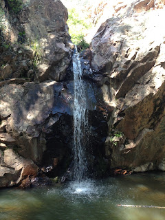
Diener Falls,Zuni Mountains- Cibola National Forest
After eating breakfast, packing up and dousing the morning campfire we were on our way by 8:00, driving on FR 480.We were going in the opposite direction now, heading towards its intersection with Forest Road 50. Narrow Ojo Redondo Canyon had a little bit of water here and there provided by springs. We passed Post Office Flat, where there is an active logging operation going on( I had heard the chainsaws earlier that morning). It's amazing to me that any logging goes on in the Zuni Mountains at all given the devastation once visited upon the range. Still, it didn't look too bad. Maybe these things proceed with a little more sense nowadays.

I had in mind two possible outings. One was to visit Cottonwood Canyon, which,by several accounts, is one of the highlights of the Zuni Mountains: a deep, aspen lined box canyon with an intermittent stream( before they plowed a railroad through, it was a trout stream according to Sherry Robinson). I also wanted to check out an interesting little side canyon that cuts the Lookout Mountain Rim. My friend Doug Scott had pointed it out to me, and on Google Earth it looked like it had steep sided bare rock walls, and beaver ponds.Here's what it looks like,although the access may be a don't ask, don't tell situation: http://www.dougscottart.com/hobbies/SlotCanyons/Red.htm
Problems arose when I got to FR 50. It was not of the quality of road I had been driving on. Instead it was rutted, muddy and with many large puddles of unknown depth. I drove for a ways in the direction of Cottonwood Canyon,but quickly came to the conclusion that even if the road was not completely impassable at some point, just driving the ten or so miles to the canyon's entrance could take a couple of hours. Disappointed, I now sought to investigate the possibility of accessing the little beaver pond box canyon. Maps indicated that a block of private property blocked access to the canyon's mouth. This isn't always an obstacle. However, the property here was fenced and posted. In addition the side roads that would get me closer seemed to be saying," you will get stuck deep in our mud." On to plan C. We drove back up FR 480 to its junction with FR 178 and headed out towards Bluewater Canyon and Lake.

On the front of the old Cibola National Forest map for the Mount Taylor RD, is a photo of a small stream flowing to a little pond at the bottom of a rocky canyon. Very picturesque. Perfect. Unlike the several photos inside the map, I couldn't see where this place was or what it was called. Drving along FR 178, looking briefly down at the map cover again , in semi- frustration , I said( maybe even out loud) something like" I want to go there!" And then within a minute or two, I was looking down at that very place( or some place very,very similar). A very happy coincidence indeed.
At first we looked down into the canyon from above. Then we drove down the road a bit and tried to walk up to it from the bottom. It was beautiful little canyon with running clear water and small waterfalls,but when we failed to reach the rocky little gorge, I knew we had followed the wrong stream. Now we headed back up and walked down to the little stream from above. We were able to climb around and down one tier of the waterfall that was now running below the silted in pond. The pond had been created by small dam in this narrow juncture of the stream. The lower part of the falls was still a mystery. Walking back to the truck, I realized I didn't have my keys. After a partially panic- stricken search for the better part of a half-hour, I found them about 5 feet from the truck in plain sight.


Now I was more determined than ever to see the lower waterfall. We drove back down a short ways, and made it happen: first down the loose dirt,rocks and dead trees on the canyon sides and then a short , but very thick bushwhack through redosier dogwood and aspen saplings, walking mainly in the stream itself. Short of stature Seamus definitely had the advantage during this bit of adventure.
The falls were lovely with a deep pool of grayish green water beneath. There was one or two bits of graffiti which made me think there's got to be an easier way of getting in here. That's when I looked to my left to see an obvious path coming down from a dry side drainage. Most likely it can be accessed by climbing a small hill from above.

Seamus and I both got into the cold water, and then we tunneled our way out, back up to the dry mesa and then to the truck. We then had an uneventful,but pretty drive through Bluewater Canyon. There may be trout that are resident in here still, but I didn't see any.
Note: the labeling of the cover photo is on the back of the map and says it is Bluewater Canyon.However it looks uncannily similar to this area I stopped at which is Diener Canyon, a Bluewater tributary.
Labels: hiking, waterfalling


0 Comments:
Post a Comment
Subscribe to Post Comments [Atom]
<< Home