Gila National Forest - Trujillo Creek


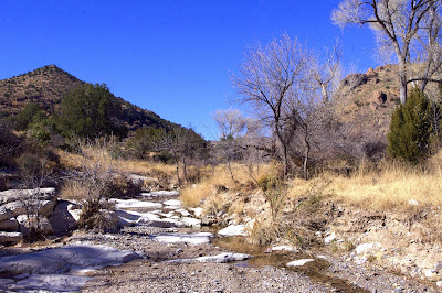


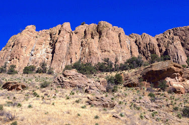
I've wanted to visit Trujillo Park for a long time. I think it's entirely about the word "park" in the name. Who doesn't want to visit a place called a park? Truthfully though, most places called "park" in the Gila are a little underwhelming. They are certainly not on the scale or the scenic majesty of the many places called "park" in the Rockies of Colorado. Some, like Gatton's Park east of Lake Roberts, are very nice. Some like Magner ( or Manger, or Magnum ) Park in the Black Range don't seem park-like ( in this case meaning large meadow areas punctuated with clusters of pines) at all. I will probably go have a look at Trujillo Park someday, but as of late, it's really canyon areas that excite me, so I decided on the box canyon on Trujillo Creek that's directly upstream of the Forest Service/private property boundary instead. I kind of got the best of both worlds as it turned out.
Over the years, I've really hammered the area along FR 157 (North Percha Road) on the north side of NM 152, camping, hiking and waterfalling. In contrast I've only hiked on the southeast side of the Black Range 4 or 5 times. The reason for this is partly because the access is limited and complicated by private property. Another is that my wife, not incorrectly, sees this section of the mountains as being "snaky," which keeps us from bringing our canine friends who we want to include in our adventures as much as possible. One thing I realized after doing the Pine Spring Mountain hike a few weeks ago, is, that like FR 157 area, visiting the Tierra Blanca Trujillo, and Stoner Creeks area has the convenience of not driving over the top of the Black Range. The starting points, even with a few miles on the low maintenance part of FR 522, are arrived at in just under 2 hours ( provided you don't get behind some serious slow-poke once leaving the pavement).
I parked at a large dispersed camping area and before I had taken 10 steps what should I spy under a bush, but several plastic bags. Contents: human crap. The way I see it is you have two choices when shitting in the woods ( or desert or wherever outdoors). Just do it in a hole you've dug and cover it over, or if you are using some kind of waterless potty that involves bags- YOU TAKE IT OUT WITH YOU! Otherwise, it's the worst of both worlds. I've picked up people's trash many, many times, but I draw the line at packing out their actual crap. What is wrong with the world? Think people, think.

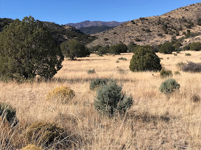
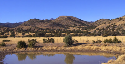
I headed up the grassy sides of a gravel and bedrock stream course, found an old road for awhile and then after crossing the ravine a twice, found a good cowpath that took me up to the saddle. I don't really like to see cows in the Black Range, but they sure make good trails. The north facing sides had a lot more piñons and brush, but I eventually found a road at a cattle tank and turned to the east. Ahead of me stretched out acres and acres of bunch grass meadow rimmed on the south side by shiny leafed live oaks, junipers and pines.


Although, definitely in better shape than Stoner Creek, I had to speculate about why this riparian area wasn't looking all that great either. Year round grazing for sure is a culprit, but also perhaps repeated flooding, drought, and just its very narrowness could be accomplices. I stopped at the fence ( which was down, not a good sign) which defines the boundary between the Gila National Forest and the private property beyond. I drank water. I ate a bar. I had arrived right at my scheduled turn around time, which was good.


Labels: fall colors, hiking
posted by Devon Fletcher at
2:04 PM
![]()
![]()


3 Comments:
I'm liking your blog! Just recently moved to Roswell from many (40+) years in Moab UT and Grand Junction CO. Can't shake the need/desire to keep exploring. Roswell offers little to no exploring that I'm used to. Spoiled? I knew that before moving to Roswell I'd have to expand my exploring (geographical) horizons..... so I came across your blog .... and BINGO. I'm planning an extended trip SW of Roswell (heading toward AZ) the end of Feb and looking for areas similar to some of your postings. I've been exposed to countless rock art locations (as you may imagine?), some unknown by many who want to know. But now I just want to hike and enjoy the "hunt and not the kill" .... although it's always a great personal reward!
My companion, Maggie Mae, a 6 y.o. border collie / black lab mix, has been my traveling and hiking companion all her life. She's very savvy and is mostly off-leash trained. As a side note, I drive a 2005 Jeep Liberty CRD (diesel) that is modified for not-so friendly terrain as well as extended periods of time in remote areas.
I'll keep browsing your blog and hope to find enough info to explore new areas!! Love your descriptions!!!
You should find a lot if you keep browsing through the archives. If you need any additional information about a location, I usually respond to the comment box within a day or two.
I forgot. I also I have book " Exploring Organ Mountains-Desert Peaks National Monument" which is available on Amazon, at several locations in Las Cruces, and at White Sands National Park if you're passing through on the way to AZ.
Post a Comment
Subscribe to Post Comments [Atom]
<< Home