Capitan Mountains Crest Hike (FR 56, FR 9037C)- Lincoln National Forest


I had originally planned this hike with us parking somewhere in the vicinity of Summit Spring, and then continuing by walking on the road ( FR 56) to the electronics site where we would pick up FT 58 and hike to the Capitan Mountains highpoint about a mile beyond. A nice 6 or so mile roundtrip with only 3 digit elevation gain was all I wanted for my very first visit to this mountain range.Well, the Summit Spring area ended up being the endpoint of our hike instead of the beginning. Here's why:
Forest Road 56 starts off as the Capitan Gap Road a mile or two east of the town of Capitan. It is a beautiful, well maintained, wide gravel road right up to the Forest Service boundary and the intersection with Forest Road 338. After that, it is a rough, but manageable, dry weather road, navigable by most 2 wheel drive vehicles with reasonable clearance. It continues this way up to Capitan Gap where it turns sharply to the east. It immediately narrows and steepens. Then, after an honest to goodness hairpin turn, it narrows and steepens even more. It grows considerably rougher as well. Past the hairpin turn, there is no turning back until a more level plateau area is reached. I'm just glad we made it to the plateau without encountering another vehicle or a downed tree. Here is where we stopped to gaze at the next pitch, which although wider, was much steeper and had the enhanced benefit of a view of an even higher drop off on the passenger side without single tree to block ones contemplation of a slide into eternity.

We had had a restless night with sinus troubles and whining dogs. While getting ready to embark that morning our anxiety levels had been pushed to the panic red zone when our puppy Nessie got loose and didn't seem particularly interested coming to us or even acknowledging who we were. Our truck is not 4 wheel drive. It is two wheel, rear wheel drive which is distinct disadvantage when climbing up steep inclines of loose rock and sand such this. Owing to these factors, we parked and started out from about the 8000 foot level.
We powered our way up on foot in what seemed like no time. Of course up on top, the road took on an innocent appearance of a rustic forest lane, similar to many roads in the Lincoln that are drivable by most vehicles in dry weather. It seemed a bitter pill to swallow at the time, until five hours later when walking down when I realized how steep and treacherous this 1/2 mile or so stretch with its 840 feet of elevation change is. I'm not saying we or others can't make it without 4WD, I can only say we made the right decision for our peace of mind that day.
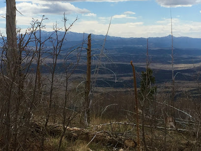
As for the hike, initially we climbed through a heavily burnt area with fantastic open views to still snowy Sierra Blanca on the south, the Jicarilla Mountains and the mesas and plains to the north, and on the west, the massive wall of West Mountain and the black hulk of Carrizozo Peak beyond.
 |
| View to Nogal Peak |
 |
On top the road lazily meandered through a mostly intact forest of Douglas fir, with some truly huge ones growing in the several lovely clearings we encountered. As we pushed on, there were more and more aspen stands both of young trees and more mature ones. They hadn't even begun to bud on this last day of April, but I thought this would make an awesome fall color drive or hike. Along the way I kept seeing signs nailed to trees that said " Block A" or "Block C", which I assume is something left over from logging days. We passed a fallen sign for Peppin and Corral Canyons, and then later passed the sign for the Padilla Trail (FT 59). We ate lunch near the sign for Ferris and Santa Rita Canyons which fall off to the north and south respectively. The upper end of Santa Rita is a beautiful park-like aspen and meadow area that can be accessed for camping by FR 9038.


I was hoping to find Summit Spring, to fill up with water for our dogs just to be on the safe side, So, we headed down the grass covered path that is Forest Road 9037C. There were many downed trees, and it seems unlikely that this "road" through the woods receives much vehicle use at this point. It was pleasant to be off the well traveled FR 56 on something more like a trail, although I did not find the spring. We turned around and began our trek back. It had been a wonderful spring day. We could hear the wind much of the time, but it never really affected us. A good experience for a first visit and with a hike of 10 miles with almost 2000 feet of elevation gain, much more of workout than I had planned.
We had a couple of folks pass us in their vehicles, both going and coming, and we saw a couple of parked trucks, but for most of the day we had the high country to ourselves. FR 56 runs along the south boundary for the Capitan Mountains Wilderness, although there are no official trails that spur off to north into the wilderness along the road, I occasionally wandered past the wilderness signs just to say I'd been in yet another New Mexico Wilderness area.


We had a couple of folks pass us in their vehicles, both going and coming, and we saw a couple of parked trucks, but for most of the day we had the high country to ourselves. FR 56 runs along the south boundary for the Capitan Mountains Wilderness, although there are no official trails that spur off to north into the wilderness along the road, I occasionally wandered past the wilderness signs just to say I'd been in yet another New Mexico Wilderness area.


 |
| 5/1/16 Snow in Ruidoso |
Labels: fall colors, hiking, scenic driving
posted by Devon Fletcher at
6:48 PM
![]()
![]()


0 Comments:
Post a Comment
Subscribe to Post Comments [Atom]
<< Home