


 |
| Propane canister and sandal in a massive pile of flood debris |
 |
| Sycamore trunk |
All good. What is problematic about visiting the box is there is no good way to get there. Following the stream down from the bridge requires over 6 miles of hiking, which after the first mile or so is without a trail. And that just gets you to the beginning of narrowest section which continues for nearly to two miles downstream. So it's going be a slow( because of the many water crossings) hike in the range of 12-16 miles roundtrip. Coming up from the confluence with the Gila River requires a similar investment in time and mileage because one has to come down 6 miles on the Sheep Corral trail just to get to the Sapillo. That route is best done as a backpack, especially if you are planning on going out the way you came. Staying for few days will also help you forget the tortuous, rough and (need I say it) slow drive on FR 282 just to get to the Sheep Corral trailhead.
There's also the option of hiking the Spring Canyon Trail, which winds along ridges and canyons high, hot and dry on the north side of the creek and then seeing if you can find a side drainage or ridge that will bring you down safely to the creek bottom when you're about 4 miles in. Not the best, but a possible option in cooler weather.
My choice was to drive in on FR 579 on Wildhorse Mesa on the opposite side of the Sapillo. This road becomes marginal after the first cattle guard. High clearance is mandatory and even though it was dry on Thursday, it was easy to see that this route becomes a muddy mess after rains or snow.
My original plan was to park about midway to the road's end and then make my way straight north to a relatively gentle ridge that would take me down to the creek without too much adventure. But after I parked and began walking, I didn't like the feel of what I was doing. I couldn't see anything but the piñons and junipers right in front of me. I can walk a straight line, but without any landmarks, I felt like I was hiking blind which, when you are without any kind of trail, feels wrong to me.
Instead I got back in the car drove bit further on until I parked just before a really rough patch. From there I began walking on the road( which actually improved and could've been driven) as it turned to the north and followed along the edge of the mesa 600 feet above Trout Creek. When the road ended shortly after a fenced area with a wildlife drinker, I followed the cowpath through the stumps of what were once very impressive juniper trees. When the path ended I continued hiking out onto a very narrow ridge. Far below me was the deep green of the many deciduous trees( boxelder, sycamore, cottonwood, willow, and walnut) of both Trout Creek and Sapillo. Rusty red cliffs terminated the dusty dry mesa opposite me.


Now I had a decision. To go down or not to go down. I knew the climb out was going to be tough, really tough if the sun ever decided to come from behind a fortuitous blanket of clouds. I banked that it wouldn't and headed down: steep, steeper and steepest 'til I was safely at the bottom right at the confluence of the two creeks.
 |
| Confluence of Sapillo and Trout Creeks |
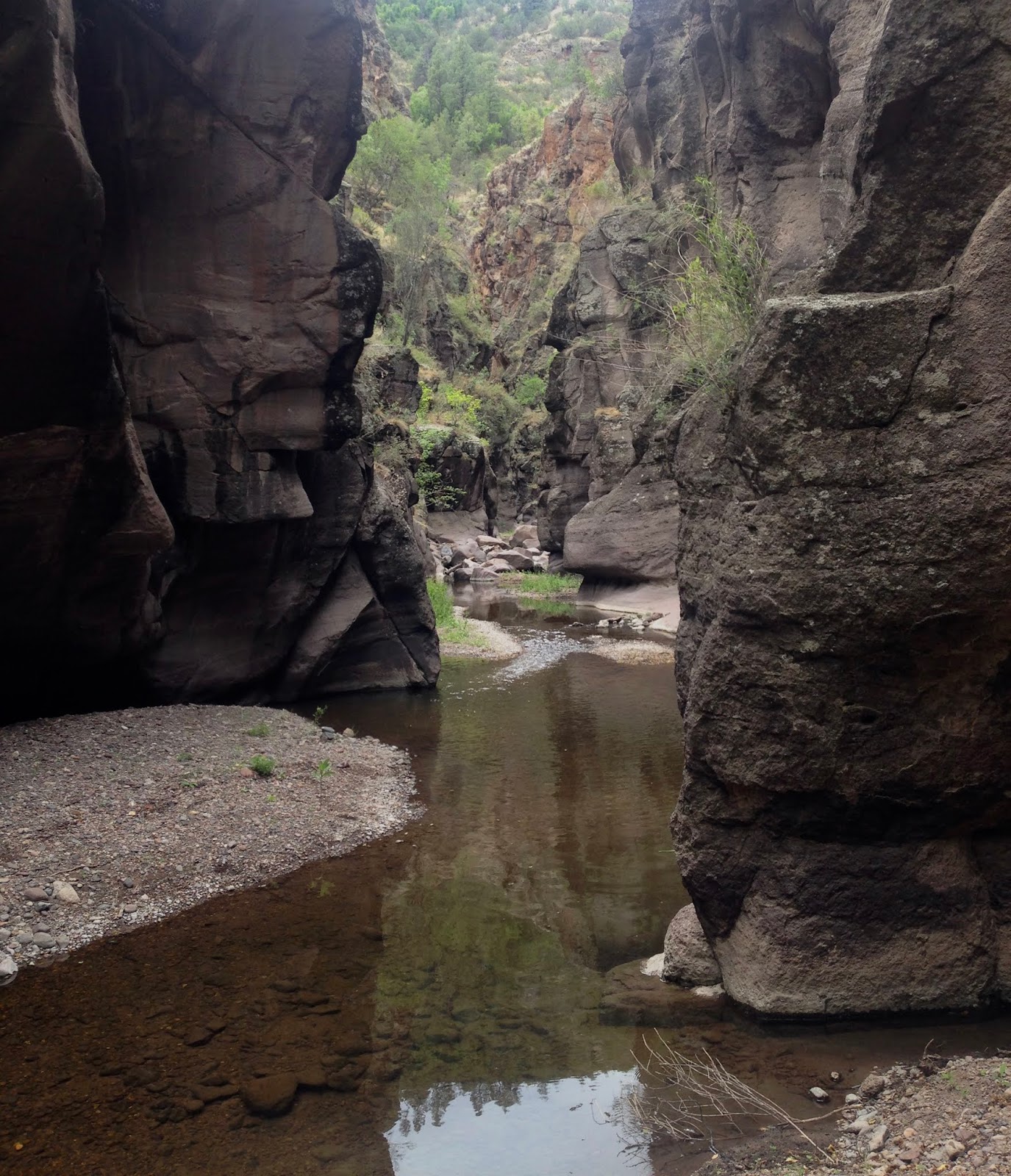
I was happy to be in the shady canyon, green with wild mint and grasses growing on its banks. I headed downstream with a heart lightened of its load of anxiety. I walked along the creekside, or rock-hopped in the creek itself, which was understandably low but its flowing waters still a joy to behold. Trout and suckers ( and maybe some chubs and dace) scurried about in the pools at my approach. I had made the decision not to fish and left the fly rod back at the truck. It was probably for the best, but I felt a little tinge of regret. It didn't last long as the scene shifted from pretty to something more akin to awe inspiring as the canyon narrowed and the basalt cliffs rose up hundreds of feet above my head.

Soon I came to a dripping and trickling 30 foot waterfall on the north side that I believe is mouth of Lower Spring Canyon. I began to have to wade more, but it was only thigh high waters at most. The canyon alternated now between open pockets with trees and grapevine, and narrow passages through solid rock strewn with enormous boulders.


I ate my lunch right at noon. My turn-around time was going to be 1:15. At 12:45 I arrived at the deepest pool yet. One that couldn't be circumvented unlike several in the wider parts of the canyon. The passage curved through the gray rock for perhaps a hundred feet. I put my pack down and waded out once, then twice. It was going to be over my head. I tried to the left and then to the right, and then right on the gravel plume dead center. It didn't matter. It was still going to be over my head. I scooped up some air with my rubber backpack, which I had brought for this occasion, and floated out to the middle once and then twice. Its qualities as floatation device were not impressive. Still I was contemplating putting my regular backpack inside of it and continuing on, when I discovered its narrowness would necessitate emptying everything out of the regular backpack and then putting the contents( and the dry backpack) inside. I should have probably checked that out back at home.

I can swim, although I never have with shoes and clothes on. It would be short swim to shallow water flowing on a gravel bar on the other side. I thought about stripping down and just going for it with my phone (my camera) around my neck in its waterproof little bag. I knew I had to be close to the 10 foot falls on Sapillo which is also very close to the Cow Creek waterfall- my hoped for destination.
There is something about being alone in wild places sometimes. This sounds strange because I go it alone almost all of the time. In the end, various factors, but mostly just that feeling of vulnerability from being alone that perhaps when I was 20, 30 or even 40 wouldn't have mattered as much to me, meant that I wouldn't swim to get to the other side. Instead I made an easy little climb to a ledge on the north side, snapped a few photos, climbed back down and began my journey back.


I was happy listening to the bird songs echoing down canyon. I ate my pear. I was soaked up to my neck. The water had been cold, but I was rapidly drying in the single digit humidity. Coming out of the deepest part of the box I could feel the heat again. I realized I had been enjoying at least 10 degree temperature difference for the last couple of hours.
Back at the confluence I re-soaked myself, drank a bottle of water, and refilled my empties with creek water. I headed up Trout Creek trying to enjoy a little more shade before heading up the hillside. Trout Creek which must've been a fishing stream at one time was a bit sad to behold. Though canopied over with riparian trees, it had no flowing water, just boulders and bedrock covered with dried algae and stagnant puddles at the bends.

I began my ascent up the steep hillside, first in the ponderosa pines and then in the thick grass sparsely wooded with dwarf scrub oaks and junipers. It was harder and took longer than I expected. Luckily the sun did not come out, but it was still quite hot. If it had, it would've been very, very bad. If you are considering this trip in the warmer months, I would recommend a shuttle hike going down from the mesa and walking out upstream to the NM 15 crossing.
It took me nearly twice as long to get back to my vehicle as the hike down to the creek, most of that time spent resting between pitches on the steep side of the mesa. On top, the flat terrain was a welcome relief. I saw a group of deer just like I had in the morning and soon I was driving back right on the schedule that I planned.

Thank you Devon for your good notes. We look forward to trying your approach to the box area; yesterday we made the trek in from Sheep Corral but ran out of time and good weather before getting to the box. Exciting trip!
ReplyDeleteThat route seemed a little long for a day hike, but I've been wanting to do a shuttle from my starting point and coming out Sheep Corral which would be around 12 tough miles.
ReplyDeleteSummer thunderstorm season may not be best time to go down there.
ReplyDeleteThank you for sharing this post! I look forward to exploring the Sapillo Box! You helped me discover it!
ReplyDelete