Sunday, August 23, 2026

Little Apache (FT 124), Sleepy Grass (FT 11) and La Pasada Encantada Trail (FT 233) - Lincoln National Forest


Sleepy Grass Trail

Little Apache Trail


Little Apache Trail


It was dry, hot and dismal in mid-July at the cabin on Horse Mountain. I had a few chores to take care of, but if it had been nice, I would have stayed several days. Instead, I called my wife and told her not to come up. I was heading back after just two nights. My wife threw out the idea of going up to Cloudcroft and staying at The Lodge for a couple of nights. It would be a mid- week stay ( I do not go to the Lincoln National Forest in vicinity of Cloudcroft or Ruidoso on weekends anymore), so I thought what the heck, lets try it. No sooner had I gotten back home, then we were off to the Sacramento Mountains.

Well it worked out really well. It had been raining up there so it was wonderfully green and mercifully cool.   I had it in mind  take this opportunity to do these hikes that are very close Cloudcroft for two reasons: first, my wife generally is not a big fan of driving long distances just to begin a hike, but also I was hoping that  because it was a Thursday that these trails would not be swamped with people as they almost always are on warm weather weekends.

 The Little Apache Trail is a loop (sort of) that we began at the back of the overflow camping (a big parking lot).

 It stays relatively level for quite a while in a shady forest of mostly smaller pine, oak, white fir and doug-fir. The amount of downfall on these ridge-tops is always a little unsettling, but it was so pleasant with sun breaking through shining on the oak leaves and the grass green at our feet, that it was easy not too worry.

 After about a mile the trail descends a small valley heading west toward Little Apache Canyon. The trees on the sides of the meadow were larger here and the stumps even bigger. Right before reaching the canyon, the trail crosses a road and skirts the edge of a large quarry. It's a bit of jarring sight to come across in the forest. For some reason it didn't bother me a whole lot.

 Now the trail began heading up Little Apache. There was tall grass in places accompanied by yellow wildflowers. We passed the only other hikers ( one couple with dogs) we saw in this section. The trail ends at the paved campground road, which was a little odd as they could've easily made it reconnect with the trailhead we started at. Still it was only  a quarter mile walk on the road and across the parking lot back to our vehicle.

Later that day we did the short La Pasada Encantada Trail right before a thunderstorm hit. The trail is graveled and has interpretive stops for sighted people and the visually handicapped. It would a great trail to introduce young children to hiking in the forest. 

 Friday morning after breakfast at Dusty Boots Cafe, we drove the short ways to the Sleepy Grass Picnic area and did a short hike up Apache Canyon ( directly across US 82 from Little Apache Canyon from the previous day). The trail is a now closed section of Forest Road 24B and I've seen it called Forest Trail 11 in a few places (though not necessarily on every map you might encounter). It ends where there is a gate on the paved road in Sleepy Grass Campground ( accessed at from the western end from NM 130). This walk is along one side of an open valley about 150 feet wide ( fairly typical for this area of the Lincoln National Forest). It's probably best done early in  the morning or late afternoon because there is not a whole lot of shade to be had. We stopped after about 6/10 of mile where we saw some not particularly shy wild horses  shuffling about in the precious shade of some aspens and conifers very close to the trail. It was still another half-mile or so to get to the very end.

 All in  all it was probably only about 6 miles of hiking for the two days, but it went a long way in lifting our spirits.

Labels: , , ,

Monday, February 23, 2026

Caballo Mountains - Sandy Tank Canyon, BLM and State Trust Lands

Bedrock canyon in the Caballo Mountains

Mexican orange

Communication installations visible on the ridgeline.

This shack, I presume, is the "homestead" that Homestead Tank is named for. It is on private property that the road passes through. I refrained from exiting my vehicle to explore.

 The Caballo Mountains, like the Sandias, Manzanos and the Fra Cristobals, align north to south close to the Rio Grande valley, and present a bold western face of towering cliffs and brief, steep canyons that are very much of a desert character  while their  eastern slopes are more gentle (as is true of the other above mentioned ranges) with longer drainages whose north facing slopes are clad in juniper and piñon. In the first decade of the 2000's we did a lot of exploring on west side, doggedly going up into many of the major canyons south of Palomas Gap, but the only hiking we had done on east side was a trip to Palomas Gap itself. I'm talking about the main high block of the range here, from Apache Gap Canyon to Palomas Gap. We've done many hikes in the canyons in the lower elevation southern reaches of the range in the vicinity of the Mcleod Hills, Redhouse Mountain all the way down to Rincon.

I thought it was time to hike in one of the east side canyons. Most of  these are nameless (excepting the ones that actually end up flowing north then east towards Palomas Gap) in the mountains while the washes, draws and arroyos they drain to in the desert flats do indeed have names. I'm calling the one I hiked Sandy Tank Canyon which appears to be an upper tributary to the southern fork of Yoast Draw. I researched and waypointed my route well, but still managed to overshoot where I wanted to start twice (once heading south, once heading back north). Everything is always very different on the ground. It would've help to have someone with me navigating with the On-X.  It's always going to be a little bit of problem visiting a new area. I had only been out here once before when driving  nearly to the top of the Caballos on the Timber Peak Road (which may or may not be County Road A003) to do a hike on the high ridge between Timber Peak and Brushy Mountain.

 So we (Nessie and I) were finally able to exit the vehicle to begin our hike. The first leg was on the old road to the dry Sandy Tank. Past the tank we stayed in the stream bed for awhile before veering right onto a cattle path on the hillside. 

Near Sandy Tank

We had go up along the side creek  we ran into in order to find a way across. We then walked down on the gray limestone bedrock eventually finding a way up on the hillside again. Soon we were back on the limestone bedrock on the northern of the two main forks of the canyon only now we were marching upstream.  Eventually we exited onto the hillside to our left and got up on the ridge. From that vantage point we  could see across the foothills of the Caballos (including Lone Mountain) across the Jornada del Muerto and out to the Chalk Hills (a sub-range of the San Andres Mountains). Looking up the ridge, I realized we weren't all that far from the high ridge at the top of the Caballos. It wouldn't have been all that difficult to just go on up, but that wasn't in the plan for today. Perhaps on another trip. 

All the high canyons had stream beds of solid rock
View to the east
Close to the top of the main ridge

For now we had to find a way down to the final fork which runs against a massive slope of layered limestone forested with piñon, Wright's silktassel and juniper. We did with a few stumbles here and there and began picking our way downstream once again on solid bedrock. Once we leveled out, we found another livestock path to follow back to the tank, where we used the road to get back to our truck.

It was gray, gray day. All day. All the photo edits I'm used to making to mitigate that washed out look from bright sunshine of a typical southern New Mexico desert scene were not useful. In fact I had in some functions (such as contrast) I had to do the exact opposite. I did see deer bouncing about on the steep hillsides. Luckily Nessie didn't.

Labels: , ,

Monday, April 8, 2024

Prehistoric Trackways National Monument - Walkabout


South Rocotillo

Apache Canyon

Robledo Mountains


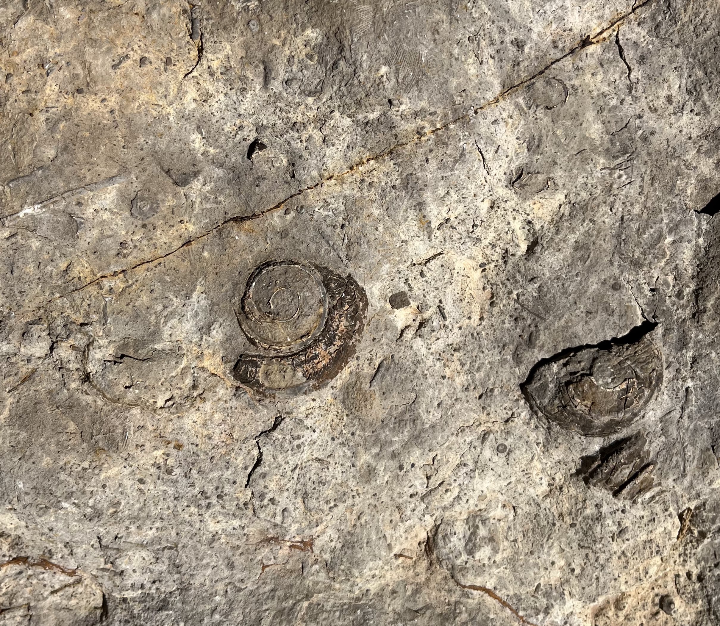
gastropod fossils


Little Apache Canyon


brachiopod fossil


Rock fall in Little Apache Canyon


South and North Rocotillo Canyons


Picacho Peak


I needed to get out quickly before the predicted wind hit. My previous two hikes on this spring break to the Good Sight Mountains, and then the Florida Mountains, involved long drives. That wasn't going to do. I had been slightly intrigued by the narrow passage of Little Apache  Canyon in the Robledos while  researching another hike earlier this year. Without too much agonizing I just went for it.

 I came at it from the east side, first going up South Rocotillo Canyon, where I encountered a stranded and or abandoned vehicle. It looked in good working order (no obvious damage). I looked in the windows all the way around- nobody home.  On my return trip it was still there with no one around. I contacted the BLM about it later. Don't know what the story was.

 I veered out of the canyon and up over a hill into Gypsum Canyon and then up over another hill and down into the main Apache Canyon where there was a reasonably easy way up just north of the volcanic plug there.

Basalt plug. Picacho Peak in the distance.

Finally arriving in  Little Apache creek on the other side of the ridge, I headed upstream. It's was pretty tight back in there as the canyon squeezed me into a narrow passage through  cliffs of sedimentary rock. I had to scramble up a dry waterfall  cut in blocky limestone, above which the canyon took on the rather dreary anonymous look of many of the dry washes that vein through the Robledos.

Dry falls

 I got back up on the ridge and decided on a slightly different route back to my trailhead. The best parts of the trip back were a too brief trek in the main Apache Canyon and two of its tributaries, and the magnificent views down into South Rocotillo Canyon.  I thought sticking to either one of these would have made a better hike than the one I chose. Those trips will just have to wait for another day. 

South Rocotillo
Apache Canyon


Labels: , , ,