Thursday, October 23, 2025

Gila National Forest - Sand Flat Canyon


Technically this hike begins in the Gila National Forest and then continues into the Apache National Forest, but nobody seems to care (and rightly so) about that distinction anymore except maybe mapmakers. The whole vast area of the Apache NF in New Mexico has been administered by the Gila NF for a very long time. Also it's not completely clear whether the first mile or so from the NM 12 bridge up to the first fork is  Cañon del Buey or Sand Flat Canyon. We continued  northwest in what is definitely Sand Flat Canyon for the rest of our hike so that's what I'm calling this here blog.

We parked off of NM 12 at the Sand Flat Rd. then crossed the highway and walked down to the canyon using a couple long forgotten roads that now serve as pleasant  paths through the pines. There is a barbed wire fencing across the canyon both up and downstream where the bridge passes overhead.  I'm getting more and more tired of getting under or through fencing as I get older. Beneath the bridge was an unexpected eyesore: a years in the making collection of junk and trash, plus a few fresh animal carcasses thrown in to boot. Why?

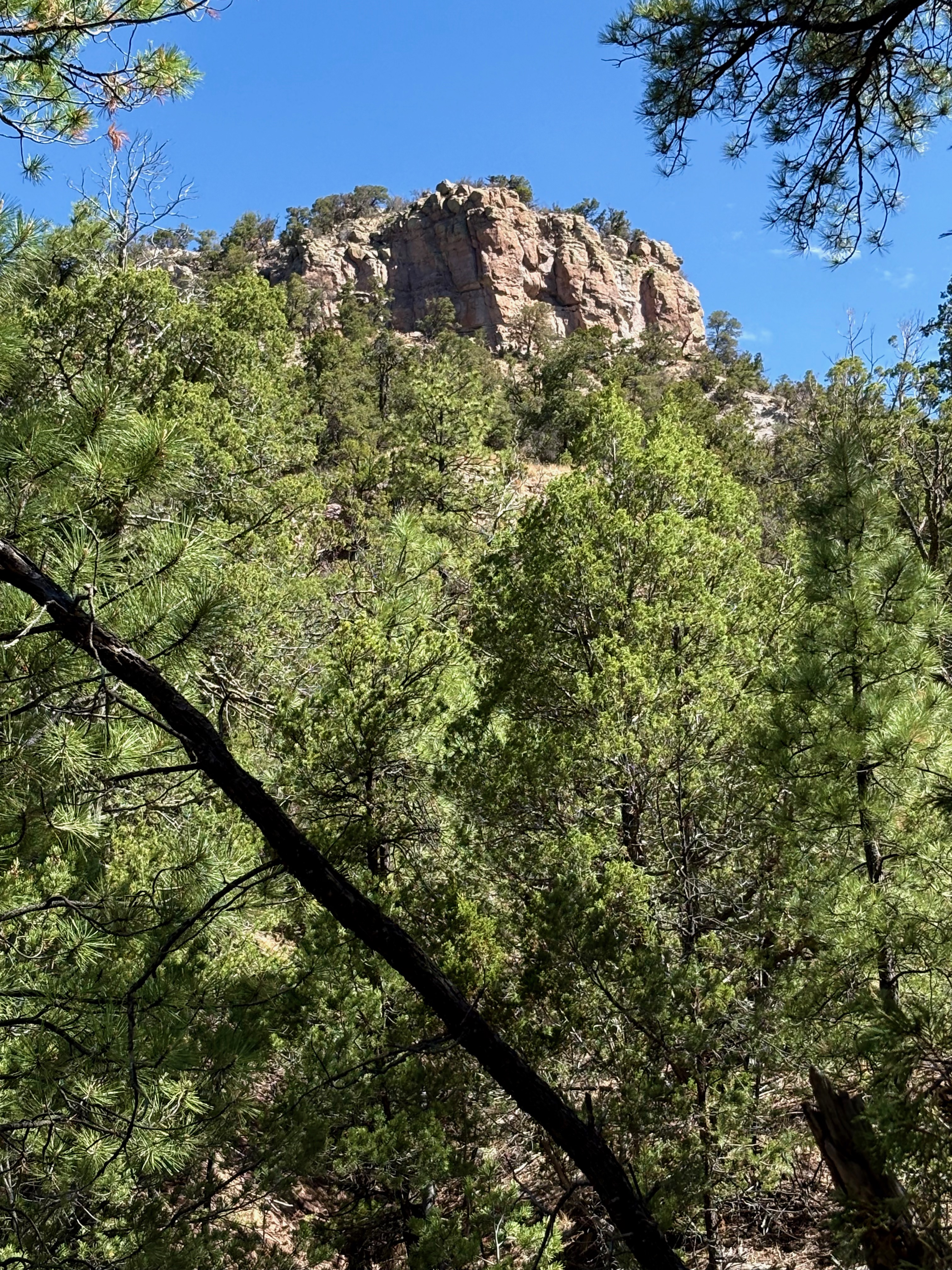
We were more than glad to get past that brief but disgusting interlude and on with our hike up the deep and rocky canyon. We admired the cliffs, and the oaks (and even a few aspens) that clung to the talus slopes beneath them. In the canyon bottom were tall and sometimes truly massive ponderosa pines and many, many boulders. There were only intermittent pathways, and the walking was slow through this  first section of rough box canyon.

 It opened wide at the above-mentioned fork. The right branch was a wide nearly level valley. To the left we followed along in the shade of the larger trees that clung to either side of the water course. We crossed a road (FR 4034W) and then continued on into a second (much lower) little box section, when that began to peter out we headed back the way we came. It looks like the right branch also has brief box section which could make for an alternate route or a lollipop loop if one were to connect the two.

It was beautiful sunny day in the first week of October, and the only day of its kind for my week of Fall Break. Rain and clouds were the theme for the rest of the time.

Labels: ,

Sunday, September 21, 2025

Horse Mountain Wilderness Study Area - Big Douglas fir


Log Canyon

 Your explorer at the base of the tree with the intrepid Nessie

This tree is located in one of the upper branches of Log Canyon where we hiked the Sunday before last. I know it's not on a par with the giants  on Vancouver Island and such, but for New Mexico it's a big one; comparable to the largest ones I've seen in the Lincoln and Gila National Forests. We came across it about a year ago, but didn't take any photos. So when we went  after breakfast on beautiful dewy morning in this lovely canyon, I had it in mind to be our destination. Enjoy!


Monday, July 28, 2025

Cibola and Apache National Forests - Gallo and Datil Mountains Scenic Driving


 Forest Road 6, Datil and Sawtooth Mountains
Views from Forest Road 93


These were a couple of driving trips 13 months apart venturing out from the cabin at Horse Mountain. Conditions couldn't have been more different for each trip. The first one we went out looking for Webster Cabin on the north side of the Datil Mountains. It was late June, cloudy, rainy with cool temps in the 70s.  It had been a wet spring and it was green everywhere we went. The road  ( FR 6) gets steadily worse as we drove north up Davenport Canyon and then down Ox Spring Canyon. Although we were, I really advise against driving it if any rain is expected. Thankfully it stayed dry, but it's easy to tell that this areas roads turn into a muddy mess the further one drives out into the Alamocita  Valley. We did find Webster Cabin and even though the maps show it as being on Forest Service property, the well maintained, low slung log structure was within a fenced area and seemingly included in a small inholding of private property. A much more recent (and apparently inhabited) house was very nearby and I didn't even feel comfortable getting out of my car to get any pictures Oh well. It was nice exploring the area anyway.

 The  more recent trip, just a few weeks ago, found the forest area for miles and miles around extremely dry. Fires had already been burning near Quemado Lake and on Pelona Mountain weeks earlier. The reason we were just doing a drive is because it was too hot for any hiking. We went to Apache Creek and then headed north. This really could be a very scenic canyon, but for the near continual eyesore at its bottom, the hideously abused, water starved, long absent riparian area along the mostly dry (now) Apache Creek, which was looking all the worse for the drought conditions. Moving on, we turned onto Forest Road 93 which winds through the pines just south of Gallo Peak before turning to the north and then east skirting the rim as it climbs up  onto Slaughter Mesa. There were occasional places to pullout and enjoy the views down to the Gallo/Gallita valleys. 

The road is pretty good for the most part, but there was some severe washboarding on several of the steeper inclines, so it's probably a good idea to take it slow. Slaughter Mesa is undergoing being transformed back into open higher-elevation meadow area. It was a little sad to behold in its moisture-deprived state, but I do want to return when things green up a bit.

Slaughter Mesa
Slaughter Mesa
Slaughter Mesa

 On the mesa we turned onto FR13 where we eventually descended along Caballeriza Canyon (where we hiked last year) and then onto County Road A 095 which took us down Patterson Canyon and back out NM 12.

Friday, July 18, 2025

Cibola National Forest - Datil Mountains

Datil Mountains


We did get out earlier the next day, but it's never early enough once summer begins. Really, we should be ending our hikes at 9:00 AM, not just beginning.  As I have spoken about before, the indirect nature of most of the roads leaves access to even the nearest ranges to Horse Mountain an hour away, which was just the case here.  We went up Davenport Canyon, over the Monument Saddle on Forest Road 6 and down the other side a short ways to park at a clearing on the right just little ways past a livestock tank that is very close to the road.

 These are not graves but memorials. William Raymond Morley was the brother of  No Life for A Lady author Agnes Morley Cleaveland. He was a prominent rancher and leading citizen in the region in the late 19th and early 20th centuries.
Almost back to the 4Runner

 My original plan for this hike had been to use these two narrow canyons on the north/northwest side of Madre Mountain to access the peak. That wasn't going to happen this day, but I did hope to at least make it to their juncture about a mile and a half away.

 Quickly leaving the pine park of mostly younger ponderosas, we headed for the thicket right along the dry stream bed. This was a mistake that we just as quickly corrected  when we got out of the  branches and onto what looked like the very indistinct remnant of a road on the south bank. 

This area must have been logged at some distant time for even though the narrow area on both sides of the silty creek bed was heavily grown in with oak, juniper, ponderosa pine, piñon, Douglas-fir and even a few spruce trees way up, there were no larger, older trees to be seen, save for one gnarly one-seed juniper.

 Either that, or perhaps the very narrow, steep nature of the canyon makes it prone to being cleared out by wind and floods periodically. It could also be that the same very narrowness limits the amount of sunlight severely thereby slowing the growth of the trees.

Eventually the road remnant became a wildlife path that crisscrossed the creek as we continued our steady ascent. Above us, along the way, rocky cliffs and buttresses could be seen when there was favorable gap in the abundant tree and shrub growth, which was infrequent for sure, but happening just enough to keep the hike from having an entirely closed in feeling. 

The hike became more of scramble as the sloping canyon sides squeezed tighter and tighter. Finally, while my wife took a breather, I made to the junction with the canyon in from the south, where things opened up quite a bit.

 I wished it was a different time of year, and I wish I hadn't pushed the limits of my still healing knee. I knew we weren't going to on this trip but I still had that urge to make the right turn keep going all the way to the grassy top of Madre Mountain.

 It will happen though.