Wednesday, May 27, 2020

Gallinas Springs Pueblo - Cibola National Forest


Sometimes what is called for is an adventure that is mostly driving. I will on occasion break my rule: Total Driving Time = Total Hiking ( or Fishing ) Time. This past weekend seemed like a good time to do it. Hot, dry and breezy in the lower elevations, and mostly likely exceptionally crowded ( with folks having little else to do to amuse themselves on a holiday weekend but take to the outdoors ) in the cool ( and accessible ) higher elevations of the Lincoln National Forest, I decided we would take off for parts unknown ( or mostly so). I had two options in mind, either the Peloncillo Mountains of the Coronado National Forest down in the Bootheel, or the Gallinas and Bear Ranges ( of the Cibola National Forest ) north of Magdalena.
 The Peloncillos had been put in my mind recently, as my friend David Soules had recently visited there in his capacity as a State Game Commissioner  on a fact finding journey regarding a wealthy landowner's desire to close a public road.
 I had gotten curious about Bear and Gallinas Mountains unit of the Cibola National Forest after looking at some properties for sale online that were inholdings within the Forest up there.
 I put the question to my wife on Sunday morning, north or west? She chose north. We made a picnic. Left the dogs at home and off we went.
 On the way out we drove on the part pavement, part gravel NM 107 to Magdalena, which is more direct, but of course the twists and turns of the several  arroyo crossings, and the fact that you can't push past 55 mph even on the straightest stretches of gravel,  means it probably doesn't save you any time. It is scenic drive though past old ranches and mines, with the high country of the San Mateos on the west and the even higher country of the Magdalenas on the east. We had been out in these parts many years ago at least as far  as the road that takes you down to the Potato Canyon trailhead.
 In Magdalena, we got on NM 169 heading northwest.  I had the idea in my back pocket of visiting some pueblo ruins I had read about in a book I had come across online that was a guide for mountain biking for the Socorro area( written some time in the 1990s). I  decided that we would get a good feel for the area, but also visit this remote site which had piqued my interest several  years ago.
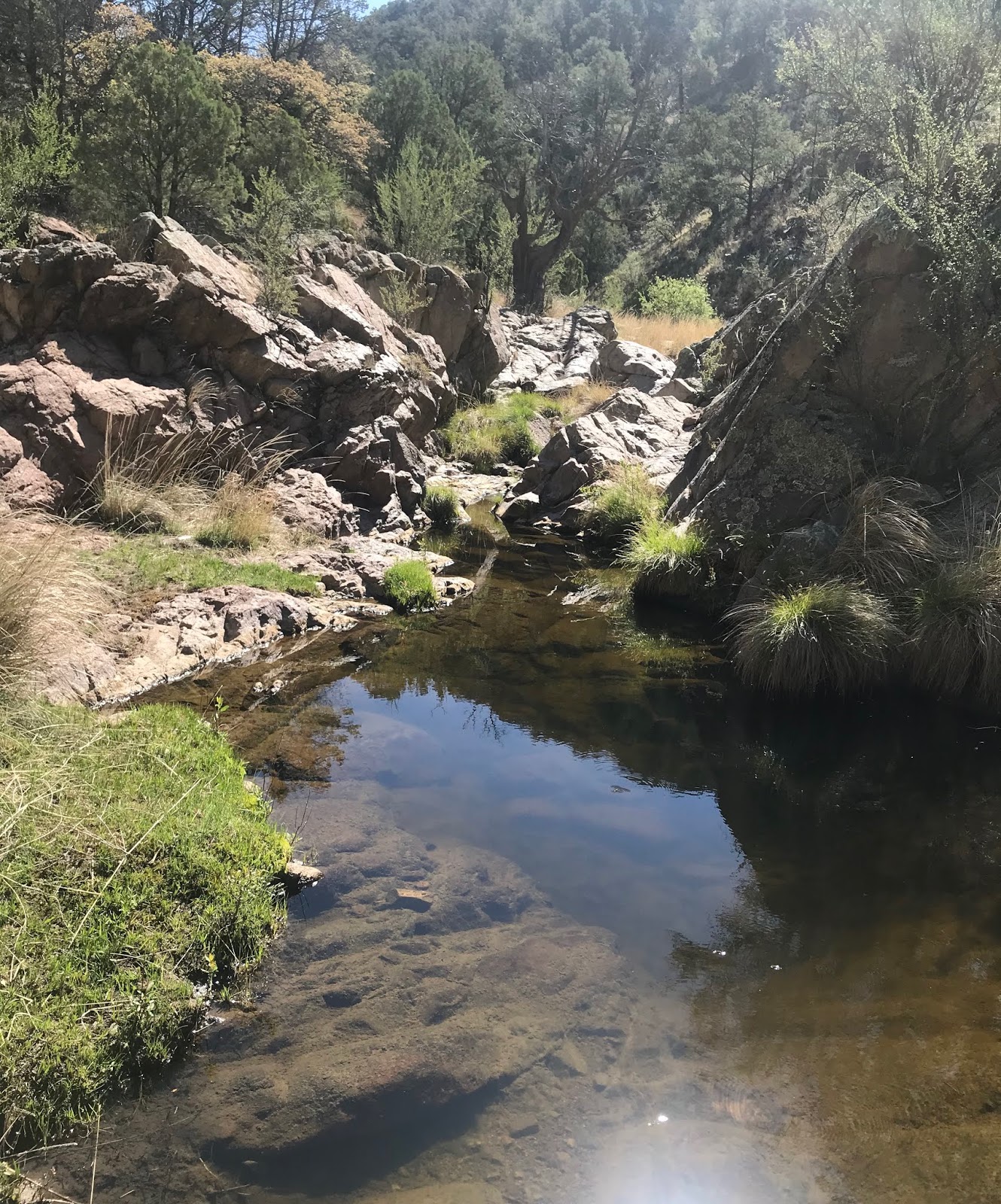
A good forest road, and only a very short stretch of a bad one, had us arriving at the ruins ( elevation approximately 7400 feet) about a half hour after going through Magdalena, and about 3 hours from the start of our trip.
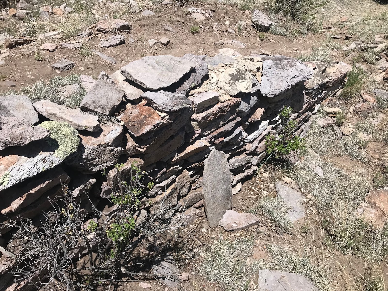
Piles of building stones covered in lichen rose up  more that 50 feet high on the south side of the wide sandy wash. It was hard to tell how much of this was the natural hill and how much was due to a multi- story dwelling.

 Small sections of walls, and outlines could be seen here and there,  including one that had been partially excavated to show off some impressive stone work.


  Gabion walls had built at the edge of the arroyo  to slow further erosion  and keep more of ruins from falling in.

We excitedly wandered around in the midday sun for an hour or more, before taking a break in  the pine needles and cones under a grandfather ponderosa and eating our lunch.
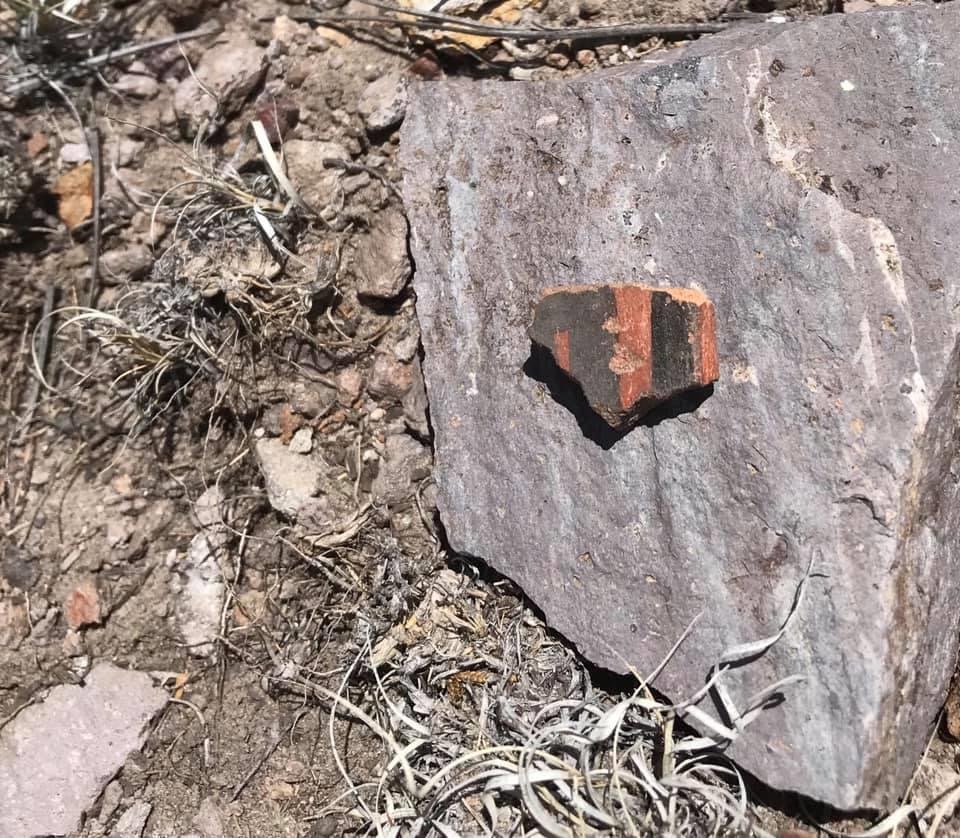
Most areas had little pottery sitting on the surface, but before we left, we found a couple of spots where it was not only plentiful but wonderfully varied.  One corner of an old cabin was discovered and rusty square nail to boot. All in all  we killed a couple of couple of hours here but could've easily spent more exploring the hillsides.


 We took a different route back passing windmills and corrals, huge ponderosa pines and big black bulls sitting in the shade of junipers on the hot afternoon,  and cows with calves getting a drink of their mother's milk. These were peaceful scenes in the hills, even if the road was nothing more than tracks in the sandy canyon, or off - camber ruts running through the grass. We re-emerged onto NM 169 began to head home, this time taking US 60 back to I-25.


NOTE: While we take photographs of artifacts, both ancient and historical, we do not collect any of them. As we saw no other dusty footprints but our own, and only one recent beer can, it would appear that few people visit this site. I would just as soon keep it that way which is why I've left out the last  of the driving directions. If you are really interested I may ( or may not )give them via email,  but not on the comments page. Truthfully, there are enough clues here that with only a little research, its location can be determined.

Labels: , ,

Tuesday, May 19, 2020

Lincoln National Forest - South San Andres Canyon


 Two years ago I was looking up at the dry waterfall, a sheer cliff of massive limestone (at least 200 but maybe closer to 300 feet high), that separates lower South San Andres Canyon from its upper reaches. Last year I went on the fantastic hike down the main stem of San Andres Canyon and decided to put its tributary on the south on my to do list.
 I got friends David and Nancy (and their dog Hank) to come with me. It was a long drive on the Westside Road ( FR 90) with deep ruts, even deeper potholes, newly graveled surfaces (which felt like driving on a gigantic washboard) and several downed trees in the road way thrown in for good measure. We then got on the truly primitive FR 90 B on top of Joplin Ridge. After about a half mile, I  had had enough and just decided to park. We began by drifting to the north and soon hit one of the uppermost branches of the canyon and began to descend. It was thick going through the live brush and the dead downfall, scrambling ever so steeply over boulders and bedrock without even the benefit of some kind of wildlife trail. We did see numerous bear droppings, some quite fresh, and once we were in the main canyon, a long trail of Barbary( and maybe Desert Bighorn) sheep droppings as well. They all must be pretty light on their feet because there was never anything like a continuous  trail as we went down the canyon.

 I was wondering if my friends were regretting coming on this adventure with me, as I was wondering if this canyon was ever going to level out just a little bit. It did, and widened some too. There were deciduous oaks, douglas firs, ash trees and the locust was blooming with beautiful purple flowers.


We did see a well traveled elk path coming to canyon through this gentler section as well. I guess they have sense enough not to come down here the way we did. The easier walking didn't last long and soon we were climbing down one small dry ( there was no water at all in the canyon) falls in the blocky limestone after another. I knew the " opening" of the canyon, and the precipice of the high dry falls was coming soon, because we now were entering into the warmer, drier zone of piñons, juniper and a variety of desert shrubs (apache plume, little leaf sumac, wrights silk tassel and sotol).
Finally, after a few easy sections of walking on pure bedrock, we began to catch glimpses of the expanse of greened over( from our very wet late winter and early spring this year) cliffs and slopes of the desert below. I continued climbing down and down. David went up on the steep north side, and Nancy stayed back aways with the short legged Hank.


 I  finally stopped. Below me were at least three more falls to negotiate to get down to a short stretch of bleached looking stream bed a hundred or so feet down that lead to the very edge of highest of the dry falls. The first one looked easy enough. The next two, it was hard to see what exactly was involved. I followed the Barbary sheep droppings up onto the north hillside for a better view. There was a bit of  trail that lead to an alcove in the cliffs. Maybe they(the sheep) like to hang out there sometimes. There may have been a way down the slope from there (bypassing those intervening falls) but once again it was hard to see exactly what it would entail.


 My friends were wanting to go back. The whole thing had taken a lot longer than I had anticipated so it was perfectly understandable. I wasn't going any further without them waiting for me. So I left it for another trip (although throughout I had had the feeling this wouldn't be a hike I would be repeating).
We certainly found an easier way back up (which made me think a return trip could be a possibility), using elk trails, weaving through openings in the low growing oak and eventually finding a livestock path through the open (heavily logged) terrain up on the ridge until we were  walking on the road for a short stretch back to the trucks. Along the way was  a turkey carcass for Hank to take a nibble at, cactus for Hank to step on and truly gigantic juniper tree.

Labels: , , , ,

Sunday, May 10, 2020

Rabb Canyon Box (upper end), Rabb Park Trail (FT 747) - Gila National Forest


 Camping off the road in Noonday Canyon, the night was as still as any I remember spending in the forest. The pines quiet. A very few stars were to be seen for the nearly full moon had the whole night seeming like moments before dawn.
 My arms were cold as I lay in my sleeping bag in the back of the pick-up. I had not brought a jacket or even a long  sleeve shirt. They got chilled down before turning in and never warmed up. I sleep very poorly when camping, but eventually I dozed. Waking up to the moon shining directly in my face, I moved to the backseat of the truck. If only I was a few inches shorter or the Tacoma a few inches wider (at times like these, a full sized pick-up would've better fit the bill) I could have stretched out, but as it was, I did fall deeply asleep. When I woke it was the genuine gray light of approaching dawn at just a quarter after six.

 I wrapped a towel over my shoulders to try and keep my arms warm. It would have been nice and easy to start a fire, but restrictions were already in place.  I ate my hard boiled eggs, bread and an orange. My phone had nearly no charge,  and, as it was my only camera this day, I got out my new Tacklife battery, which I had bought for charging a dead car battery when in need, and tested out its phone charging capability. I went up on the hillside and waited for the sun to come over the ridge, grateful for its first warming first rays, when they did arrive. In about a half hour the battery  had the phone up to seventy percent. I  thought, good enough, got my day pack ready, and off I went on the Rabb Park Trail (FT 747) directly across the road.

 I've been on this one a couple times before, so I knew what to expect: another Gila National Forest uphill both ways special.  It starts with a rough steep climb on loose gravel and rock, followed by a pretty leisurely stroll on the ridge top and then a  long descent through a side canyon down into Rabb Park, which means a long, slow ascent, a pleasant stroll, and a slippery descent on the return trip . I  had two advantages this time though. First, since I was starting from the actual trailhead, and not from the parking area right off of NM 152, I wouldn't  be adding an extra mile and a quarter to my hike. Second, since I had camped, I was actually getting started, at  a cool 8 o'clock and really could've started earlier had I not had the phone issue.

 I was in Rabb Canyon in 47 minutes. Instead of heading upstream, following the trail to the park, I turned left and began boulder hopping and scrambling around the deep pools of tea colored water. I stepped lightly through the tall grass that made the runs in between nearly invisible even though the trickling sound was always there.


Early on, I  inadvertently disturbed a red tail hawk at close quarters as it drank from the stream. Flying up to a juniper on the hillside, it let me know its displeasure with a few grouchy screeches. Down and down  I went hoping to  finish my section  hike of the box canyon which I had completed the lower end of  in March of last year ( I did  complete it ). Pale frogs scooted  about on the bottom of the still pools that had only the thinnest layers of silt and organic material covering the bedrock. Piles of sticks and branches on the low benches streamside made it clear that when this narrowest section of the stream floods the water has no place to go but up. Canyon wren laughter, a constant on these warm spring days, and  the splashing of small falls were the musical accompaniment  for my two hours in the box. I came to a fence that was strung high over some twists and turns in the  smooth bedrock, high enough for a nimble footed cows to go under and leave their allotment. Luckily by the look of things, not many try it.  Rabb Canyon Box is a strange, unique place in the Gila. Despite being nearly in the desert, it seems to have a perennial flow. Despite that flow, there are few riparian trees here, just an occasional narrowleaf cottonwood or group of willows.

Before I left, I soaked my feet, wet my shirt, pants and hat.  I had planned to  get in but the water was just too cold. I could tell by the way it made my pale bare feet ache.
 The walk back was over before I knew it.  I made a sardine sandwich, ate my Wise potato chips and drank my caffeine free, Diet Coke as I sat on the ground in the shade of the pines.

Labels: , , , , ,