I've toyed within the last year or so at having a look at the site, which Yeo meticulously documented, even venturing out there last year and walking a very small part of the perimeter of the flow. Unfortunately there are several problems with accessing the site, First, the gate on what is a county road is now locked at the entrance to the old cinder quarry ( which is on State Land Trust property). Perhaps people ended up driving onto the private property of Stahmann's pecan orchard ( as I did inadvertently the first time I came out to the area) too frequently? This means a mile and half walk through the unattractive mine area to even get near to some of the petroglyphs. Second, while the most of glyphs are on the blocky boulders on the steep slopes of the flow and technically on either state, BLM or City of Las Cruces property, it seems a sure way to get some unfriendly attention from the private property owners at the bottom, never mind the difficulty in climbing down to locate the already difficult to see glyphs which would mostly pointed away from viewing from the top.
I had another idea. Less that two miles to the south is another lava flow, which I later learned is called the San Miguel or "Finger" Flow, entirely on accessible BLM land. It's about 2 miles long, but very narrow, only few hundred feet wide for most of its length, which is quite a contrast to the wide spreading Santo Tomas flow which has a perimeter of 7.5 miles. The San Miguel Flow's perimeter is less than half that, which makes examining it manageable in a single outing. Not that I knew there was anything there to see, other than lava. I was just going on, as they used say " a hunch," based on its proximity to the known site.
Off I went on Tuesday morning, with friends David and Nancy Soules along. After parking, we marched across the sandy mesa, with the flow, which sits below it, invisible to us, but with the small volcanic cone it erupted from ( now completely covered by sand and shrubs) on our right. Soon we were in the arroyo on the north side that runs along the blocks of gray, red and black rock that define the 30-50 foot high slopes of the flow.
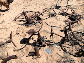
There were many good surfaces that we examined but found nothing in the way of rock art. We did find several piles of vintage metal and glass junk: old rusty bikes, trikes, car parts, and pipe mixed with Ovaltine jars, soup and beer cans, and soda bottles. It's strange how finding old trash (none of it seemed more recent than the 1960's ) just dumped in the desert is interesting, whereas if it were from the last year, it would be horrifying. Perhaps the only difference between trash and an artifact or between graffiti and rock art is time.
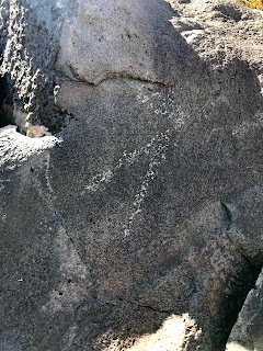
Well, we were pretty much to the point of giving up, with the hiking in the sand having me wondering when were we going to get to the narrow point that is the end of flow, when . . . David saw something, and then nearby, another something and we knew we were into the petroglyphs which I hoped would be there. Some were faint, some indistinct, and some repatinated, but others were clear and bold. We moved up and down, awkwardly climbing in, out and around the boulders looking for more and finding more.
Eventually I circled the around and climbed the road, which is no longer navigable to vehicles, to the top and then I moved on the south side, where almost immediately more images , strange, and most, unlike the other art I've seen around our region began to appear. From then on it was gazing and climbing, getting scratched by mesquite and banging/scraping my ankles on the rock to find more. Only a few were down at the level of the arroyo.
Some glyphs had been lightly scratched, and there was one set of perfectly pecked initials, but otherwise the site was remarkably untouched given its nearness to civilization ( only a little over a mile to the village of San Miguel).
The day had warmed considerably, but the wind had never been problem. I went up on top to walk back while Nancy and David continued along in the arroyo on the south side. I contemplated the weird "avenue" that had been cleared at some undetermined time in past. I won't bore you the many theories we've come up with as to its purpose or age, but if anyone out there knows, please clue us in.
I rousted a coyote who trotted off through the creosote to the north. I was finally tired and the walk back to vehicle began to feel like trudge as I tried to keep my speed up. The roundtrip distance clocked in at over 6.5 miles, most, except the bits on top, in the loose sand.
It's always fun to find a site on speculation, and I've had very good luck over this past year. This site, though, was known ( given the dump sites and scratching) as are almost all of them, it just may have been needing to be rediscovered.
This was the last time I saw David Soules. He was very happy to be " discovering" this site with me. He died three days later.


I was sad to hear of David Soules passing. So sorry for your loss.
ReplyDeleteThank you.
ReplyDeleteI moved to El Paso 4 years ago and came across your blog as I was trying to educate myself on S. NM. Sorry to hear about your friend, I googled him and he sounded like a wonderful person. Thanks for sharing your knowledge and experiences adventuring throughout the local area, I enjoy checking in and learning of your experiences.
ReplyDeleteYou're welcome, and thank you for your kind words. David was the best.
ReplyDelete