The first portion of this hike I did last winter with friend, David Soules. This time I was venturing beyond our exploration to the north to look at low ridge of dark volcanic rock that splits the mesa. Climbing upward, after leaving the calm down in Johnson Spring Arroyo, the wind really began to pick up. Ahead, next to a yucca, I saw what I thought was the rear end of either a deer or a javelina. As I got closer and closer, I decided that it must just be rock, because any animal would've up and run by now. Of course, soon afterward, I was proven wrong and right, when the doe stood up as I was probably only 30 or 40 feet away. Nearby, her mate, a nice looking buck, stood up as well. He had been blending in so well, I hadn't noticed him at all. They both gave me a long stare, and I believe if I hadn't taken a step closer, it could've been longer still. Then, after those moments when time stands still, it rapidly readjusts, and they were gone with high bounds over the ridge.
On top of the ridge, the wind was blowing a full gale, and unfortunately getting down on the other side didn't help much, because it was coming from the northeast. I explored the rocks, moving back forth on either side. Flakes of many colors of quartz material from point and tool making were everywhere on top, and eventually I found one nice panel of petroglyphs. The wind was blowing so hard though, I had a hard time staying still while I took my photographs. Beyond there, I found one more on a boulder at one of the many little "passes": open areas that made it easy to traverse through the rocks.
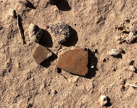
Eventually I made my way down to the flats on the east side, and there in the creosote studded sand were more flakes, and lo and behold, ancient pottery as well. The rocky ridge split into two, and I walked south in a small ravine between, down to a confluence where I turned back and climbed up a dry cascade of gray bedrock. In the sand back on the west( south) side eventually I was finding more and more cryptocrystalline quartz material, as I headed towards some boulders I had left out of my initial walk on the ridge. There was even a partial point.
 |
| Debitage |
I revisited the area with pottery, and stone manos we had found last year and somehow managed to lose the cap to one of my steel water bottles as I picnicked in the sand ( two days later I somehow managed to lose an entire steel bottle on another hike). I've grown quite fond of sardines in Louisiana hot sauce, and I thoroughly enjoyed sitting down to a repast where many an ancient soul had done the same perhaps with whatever fish that could be taken from the nearby Rio Grande, and maybe some kind of chile. Who knows
 |
| Brown and gray pottery sherds |
 |
| Brown ware pottery sherds |
I found footprints in several places on the mesa, which worried me a bit, but I believe they belonged to hunters, not artifact poachers. I decided to descend to my truck waiting in the arroyo through a tributary to the very narrow canyon that cuts through the hill of volcanic rock, that we had ascended last year. Got a thorn from a dessiccated cactus clinging to the rock walls, deep into my index finger for my trouble.


Devon, we purchased your book and tried the our first hike and discovered people had gated, barb wired and made a mess out of getting to the cave. What happened? I thought this was National Monument land? (Cave near Rio Grande river hike by Prehistoric Trackways. Today's date is 2-13-22.)
ReplyDeleteI am assuming you are talking about the Geronimo's cave hike. I haven't been out there in couple of years. There is state land, and private land on the west side of the river to contend with, plus the International Boundary Waters Commission has posting lots of signs and maybe doing some fencing too. Without being able to know where you crossed it's hard to advise you. Crossing through the state land is the safest bet because it allows you to walk onto BLM land and then head north. If you have GPS route of your attempted hike I can try to help you further. There is also a spot a little farther north near a little horseshoe shaped sub division where the BLM land actually crosses the river and levy which may be preferable now..
ReplyDeleteIt occurs to me now that you are talking about Chavez Cave, not Geronimo's cave. It is definitely BLM land right up to the east bank of the river. Fencing on the west bank was pretty dilapidated the last time I visited. Easily crossed. To use our Monument you have to get used to going over and under a lot of barbed-wire fencing. Most of it is just for keeping cattle in, not for keeping people out. The gate on Rocky Acres trail is usually locked, but not always. If it is just park directly across the river from the cave drainage and make your way across. You may have to carry your boots and get your feet a little wet. I hope you made it. Last time I was out there the gate on the road was open which made things a lot easier.
ReplyDelete