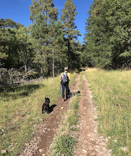
The problem with the Old Cloudcroft Highway Trail is that it runs too close to the present day Cloudcroft Highway ( US 82 ). The noise level even on Sunday afternoon was more than a little distracting on an otherwise lovely walk along lower Bailey Canyon.
I had wanted to get in a forest hike before the weekend was over, so I devised this loop on some of the closest ( to Las Cruces) real forest trails I could. So even though we got a late ( we didn't leave the house until around 12:30 ), the shorter drive meant we had plenty of time to finish this 5 mile loop. Despite the highway noise at the beginning and ending of our walk, I was still very glad to have done this hike, where despite being so close to ( and a little bit in) Cloudcroft, we did not see a single other hiker the entire time.
We parked at the Bailey Canyon trailhead walked down the road and picked up FT 5004 which quickly makes long, kind of creepy passage, underneath the road through a narrow, low ceilinged (dark) tunnel. Emerging on the other side we followed the two track that runs along the grassy canyon bottom. I'm not sure why there was so much traffic on US 82 at around 2:00 PM on a random Sunday afternoon, but I was glad when after a little ways past the first trail intersection, FT 5002 angled southeast into the densely forested tributary Mexican Canyon and the noise subsided.

 This was the nicest part of our trip. A shady and gradual climb with abundant big tooth maples on both sides of the trail, this section should be absolutely spectacular when the peak of fall color kicks in, in about a week or so. My wife called this part an " amble." After crossing Mexican Canyon, the climbing became more earnest and then the we walked out into the bright ( and warm) afternoon sun. The maples and douglas firs were gone, now replaced by scrubby chokecherry and dry slope shrubs. Our black dogs were hot and so were we, but we climbed on, past the crumbling limestone on the trailside. Views to the west opened up, but we really weren't in the mood to enjoy them.
My wife described this section as a " trudge." I don't disagree.

Eventually we were relieved as the trail leveled out ( sort of ), as I imagine so were the drivers back in the day who realized they were finally in Cloudcroft after the this last treacherous climb on the narrow road looking several hundred steep feet down into Toboggan Canyon the whole time.
We passed the unsigned intersection with FT 5001 and then the trail continued to its dead end at inactive gravel and cement operation just off of NM 130. We backtracked a bit and found the abandoned road that went steeply down into Toboggan Canyon. There was bit of water in the gravel streambed here on this otherwise completely dry hike. There was was a closed metal gate which we were able to slip through on the side without actually opening it. After passing through we saw there were some no trespassing signs hanging on it, which we had not noticed it at first because the sides with words were facing in on the approach side. Shortly afterward we went through an open wire gate. Toboggan Canyon Trail ( FT 5003 ) was cool, but had little else to recommend it. It's very steep, and artificially open because of clearing for the powerlines that run through it. At the intersection we turned and headed back along our original canyon where non- native elm trees were grew along with aspens that seemed so bright and golden with sun shining through them, but were actually quite dull with black spots on many of the leaves.

Walking through the tunnel again, I was thankful the clouds of insects inside were not mosquitos, because it would have been feast if they were.
NOTE: The uppermost parts ( less than 1/4 mile on each) of both FT 5002 and FT 5003 are on private property.


No comments:
Post a Comment