Only managed a three short hikes this past two weekends. One I already covered was to Chavez Cave. The first one was on the Canyon Loop Trail on the south side of Picacho Peak. It's a scenic little canyon with some nice cliffs and dry falls. It doesn't look like it gets a lot of traffic because most people just head up the trail to the top of Picacho Peak. We saw rabbits and the dogs pulled me up a hillside when they caught site of four deer. I'm always impressed how the whole Picacho Peak/Box Canyon area is nicer than I remember each time I revisit. I guess it's under appreciated by me due to its being so close to town and therefore a little over utilized for my taste.
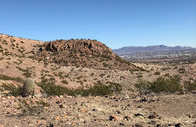
The last of three hikes was on this past Sunday to little area nearby between some headwater branches of Spring Canyon and Apache Canyon. Seamus and I walked around a little hill that when viewed on Google Earth looks like a bagel or donut. Not much to report. Nice mollusk fossils in the limestone bedrock. The backs of javelina as they trotted through the pale grass in the streambed. A coyote on the ridge above us. Blue skies. Sun. Then the wind began and we headed back.


Sounds good, Devin. Do you have directions to the trailhead. Thanks so much.
ReplyDeleteThis comment has been removed by the author.
ReplyDeleteDrive about 6.5 miles from the beginning of the Corralitos Rd. There is a very primitive road on the right, just before the Corralitos road makes a nearly right angled turn to the west. Head east on the primitive road, staying left at any intersections. You will pass a cattle tank and then begin ascending a steep hill. About 3.5 miles from where you turned, you can begin looking for parking somewhere on top of the hill. The canyons are directly east. Once you leave the Corralitos road, the driving conditions are very, very, very poor and of course very, very,
ReplyDeletevery slow.