Saturday, December 28, 2019

Rincon Falls - Caballo Mountains


Don't get too excited. Owing to its low elevation, desert setting, Rincon Falls is  bone dry 99 percent of the time. It must be something to see though, when, perhaps due to heavy monsoon downpour or some prolonged winter rains, it does flow, cascading over its two major tiers for a drop ( I'm estimating) of 150 feet.
 One might have to brave some miserable, if not dangerous conditions to see it wet, however it's still a very worth destination even without the water.
The logistics of getting there, even though it's less than 2 miles as the crow flies from I-25, are not the best.  It may appear that there is a road that goes under the highway from Rincon to a dam lower down the canyon. It looks a bit sketchy on Google earth if this is entirely feasible, as the road tracks look like they terminate on the west side, and the continuation of the "road " is actually seen to be from people leaving directly off of the north bound lanes of I-25 which I am sure is frowned upon by both the highway department and the state police.
 My solution for getting reasonably close was to start off from the little red mountains ( the southern terminus of the Caballos ) west of the town with all the  broadcast and electronic installations atop it. There is a road, which once it starts climbing is not a good one and not at all suitable for low clearance sedans. If it's wet at all just put  the SUV, Jeep or truck in 4 - wheel drive or come back another day. The 4Runner made it up fine in 2 wheel ( it was dry) but I put it in Lo 4 on the way back down.
 The walking started off rough, over chunky loose volcanic rock as Seamus and I made our way down the hill to the west. Seamus was off leash, and before reaching the bottom, I realized he was balking at coming  down. Then I saw why. Cows. He's never been too happy about cows. Perhaps because they just sit there, not willing to move, as desert cattle do  to protect their limited amount of energy in this land of very limited food resources.   This immobility may be seen as threat, because anything with four legs that runs away from him, he is all too happy to give chase, much to his owners consternation.

 I had to  walk back up the hill part ways, give him a treat and put him on the leash to run the gauntlet of the dozen or so black, red and tan cows and calves that were lazily grazing ( what I don't know )  or just lying along the confluence of two ravines. It was a good thing I got him on the leash, even though it made for slower going, because a short while later, after climbing through a rough section of boulders and loose rock near some prospects, we came nearly face to face ( less than 75 feet) with two good sized buck mule deer with half dozen or so of their companions in the more gentle upper reaches of the canyon bottom. After a mutual stare that lasted 20 seconds, I went for my camera in my pocket,  and they, of course, trotted off, but not in a hurry and not too far, so I managed a few impressionistic distance shots.

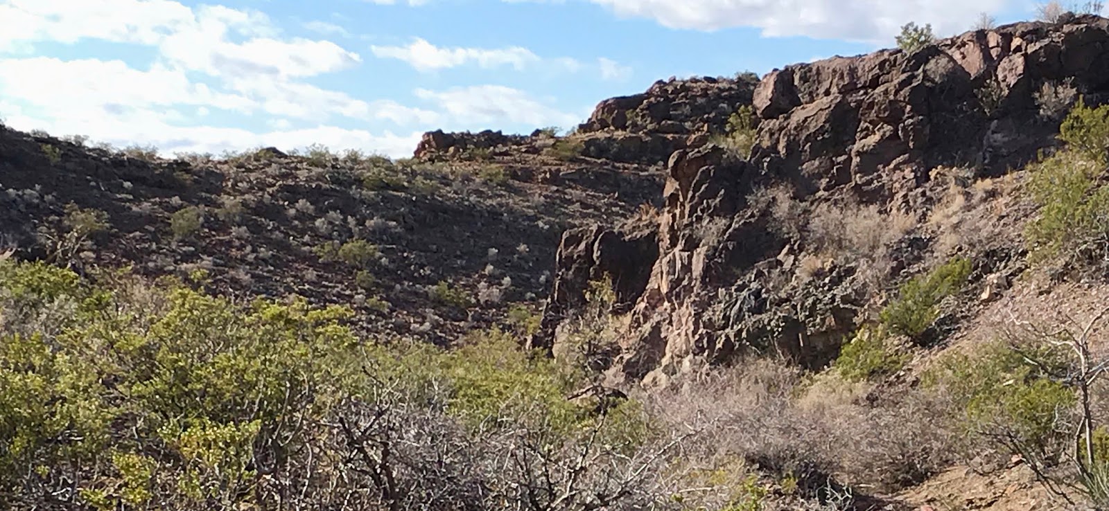
 We went over the hill, heading slightly northwest and then down into the upper end of the falls canyon ( although at the time I wasn't entirely sure there would be a falls). It was easy walking for short ways, with even a few small puddles in the bedrock for Seamie to drink from. Quickly we were on the precipice of the upper tier which looked to be  20 -30 feet high and not at all a safe bet for descending. One wall was carved into an overhang. The other side was a blackened with desert varnish. About 75 feet forward the stream course disappeared.

We walked out on the ledge on the west side and then back tracked  and went over  a small hill. The descent on the opposite side was a steep one and I landed on my posterior several times. At the bottom we followed a sinuous little ravine that had it's own little pour -off at exposing layers of red and cream sedimentary rock.

 We hiked, hopped and scrambled until we were standing in the gravel at the bottom of the 100 foot second tier that was carved, cut and chopped  wildly out of the red and gray rock. We were finally in  some shade because the falls occupies a very narrow gash in the hillside that allows little sunshine in, even at the noon hour, which it was. There must be enough for the large clustered hackberry tree that grows on south facing side though.


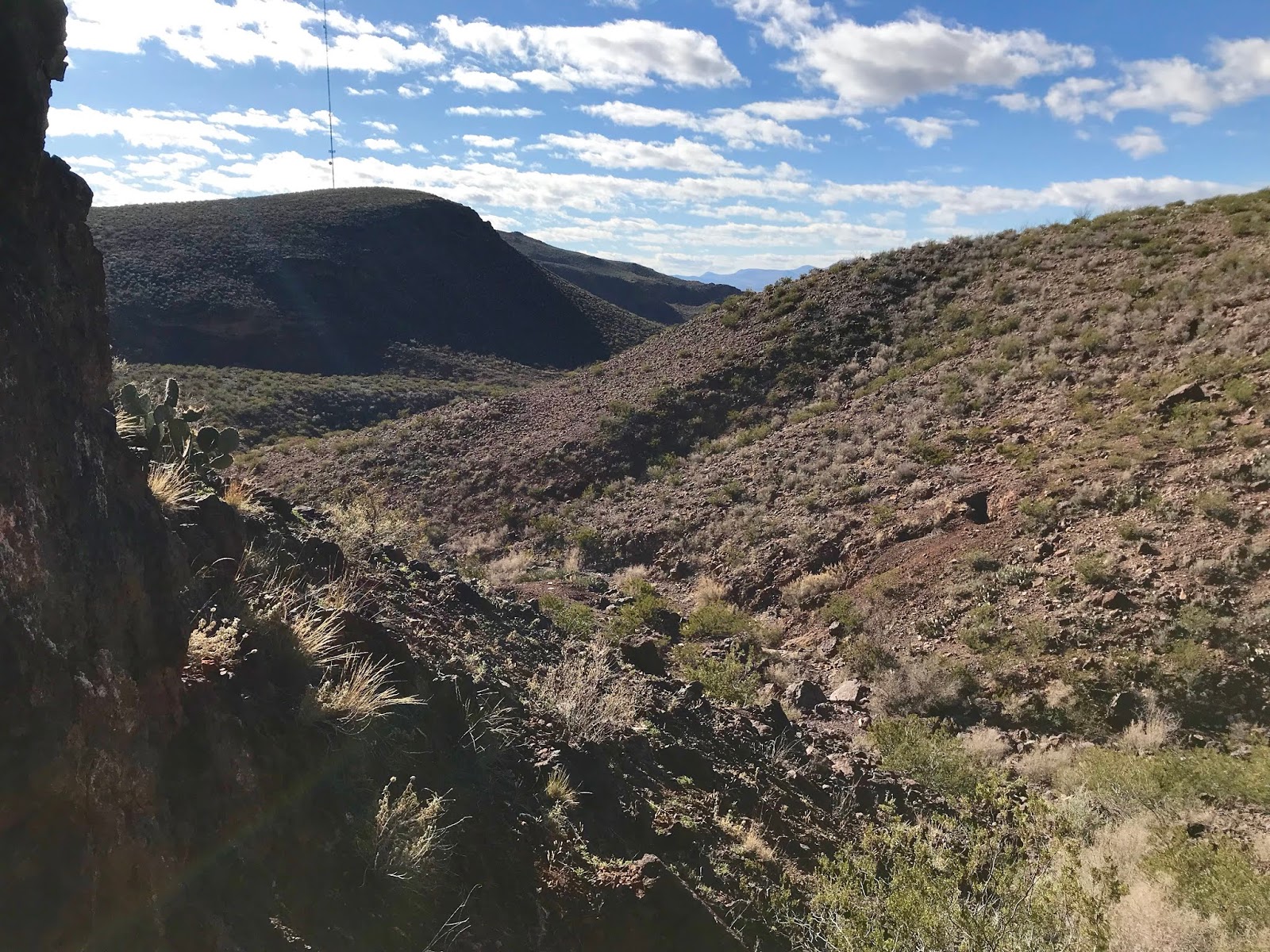
We rested a bit and then backtracked a bit and climbed the hill on the opposite side we came down. We had one more look down the falls from the top, and then set off to explore the upper end of the canyon past where we had come in.
 There wasn't much to report. A lingering large puddle in the sand, veins of barite? and calcite running through black cliffs, nodules of layered minerals, green and blue pebbles and rocks were there to be seen, and I regret not collecting a few samples.

Where the canyon opened out of this narrow little upper box, we turned back toward the way we came. I spotted a buck on top of ridge luckily before Seamus saw it and quickly leashed him up. Once again, Seamus was not happy that we had to make our way past the  cows, who had not moved much in the four hours since we had last seen them.
 A good desert outing on a beautifully calm, blue sky, white cloud day.


Labels: , , , ,

Monday, December 23, 2019

Whitethorn Canyon - Caballo Mountains


We did this hike on Saturday (12/21/19) under the blue skies and warm sun. Starting  out from near the cattle tank in Palm Park, we followed the path of the old road, if not the road itself which has virtually disappeared in this section due to the severe erosion which has left a web of deep gullies in its place.
 Through and by the enormous boulders that have tumbled down from the volcanic cliffs, we walked up to a gap in the ridge line and then over to the other side.  We followed a second road  briefly south and then went cross-country to the arroyo I'd been planning to visit. It was easy walking in the sand and gravel compacted by recent rains. The many branches narrowed to single little boxed up canyon lined with whitethorn acacia trees. There was some shade for our dogs in the bends which were very grateful for as it was quite a warm day for December 21st.
Dark cliffs contained a myriad of veins  of white minerals ( barite?). In the gray bedrock were in-situ geodes, some with  bubbly black ( manganese?) minerals.

All throughout the walking there was jasper, chert, agate and other cryptocrystalline quartz in the channel and on the banks, certainly a wealth of materials for making stone tools. We saw a deer bound up the rough hillside.  A few tiny birds flitted  in the bare branches.
When the box opened up, we turned around.

 On the way back we gave our greeting to the petroglyphs on the boulders in Palm Park, and admired the rare sight of the full cattle tank, thanks to all the winter rain we've been receiving. A wonderfully peaceful, if unspectacular hike came to end as the shadows grew fast on the shortest day of the year.

Labels: , , ,

Wednesday, December 11, 2019

Canyon Next Door


 I did this little 5 miler on Saturday morning (12/7/2019). Since I now know it to be on State Parks, BLM and State trust lands, I decided to have look at the canyon next door (on the south) to the very well known and well traveled Slot Canyon. The scenery, cuestas and cliffs of conglomerates and layered basalt and banded rhyolite, was nice, but not spectacular. I  then moved on to the next canyon to the south. Scenery there wasn't much, so climbed up to the mesa in between and began working my way over hills and ridges back to the arroyo which contains the Slot Canyon. I had a look at the Slot Canyon from above, but didn't go in. I'm still  wondering if this narrow little wonder was created if and when the arroyo was dammed by humans and the storm flow found passage through the easily eroded conglomerate it's carved in, or, if the arroyo, either through a flood event or a build-up of sediments over time,  dammed itself and naturally changed course and began working its way more directly to the Rio Grande.
 NOTE: at the start of this hike I hacked off another bogus NO TRESPASSING sign from the gate.

Labels: , ,

Wednesday, December 4, 2019

Dry Canyon Trail ( FT 5774 ) - Lincoln National Forest


After purchasing my Christmas tree cutting permits at the Lincoln NF offices in Alamogordo, I had a few hours to kill before sunset. I decided on the closest forest trail I knew of : FT 5774, Dry Canyon.
 I have passed the access road to this trailhead many, many times while driving on US 82 to more lofty destinations in the forest, and I've always wondered what this trail would be like, but there are  more than a few reasons why it has never been high on my list of choices when visiting the Sacramento District. Even from the highway, it looks more like a desert hike than a forest one, and if I want to hike in the desert it makes more sense to stay closer to home. Near the trailhead there is a recreational shooting area. Beside the fact that I don't particularly care to be around folks shooting guns, I don't like listening to the gunshots the whole time while I'm hiking. There are frequently open bed trailers parked at trailhead also which means, as with many Lincoln NF trails, you will be encountering  motorized traffic during your hike.
Well, all of these were proven to be valid concerns before my 2 hour walk was over.  In addition, the scenery, while nice when scanning distant peaks and cliffs above,  when looking closer to the ground   was the typical desert shrubbery that takes over when an area that is over utilized by livestock.  " Meadow " areas were thick with cow patties and well cropped grasses.
 About 1 3/4 miles in  I went up a side road on the east and found the culprits lounging around in the dry stream bottom where the now contained and piped Dry Canyon Spring # 2 is located. Exploring this canyon ( Rock House Canyon) might be a more worthy destination at some later date, but not one I had time for that day. Back on the main trail I passed an old corral, and walked another 1/2 mile or so, crossing the gravelly creek a couple of more times before turning around.


 I met a local couple on the way back whom I chatted with briefly. Initially there were understandably surprised when they thought I traveled all the way from Las Cruces to hike " this trail ?" I explained about the permits which made it seem a bit more reasonable.
 I've hiked about a mile of the upper end of this trail in the forest, and now a couple of miles of the lower end. There is still around 2 or so miles in the middle I haven't seen, but they may not be worth it, or at least not from the bottom end going up.

Labels:

Monday, December 2, 2019

Cedar Hills- Another Walkabout - Organ Mountains-Desert Peaks National Monument


 I wanted to get out in the desert sunshine, even if just for a  few hours, a couple of Sundays ago. I settled on a backdoor route to the Foster Box Canyon. I went up over hills, looking at rocks. I went down towards arroyos, trying not to lose too much elevation against the next hill to conquer. Along the way were four deer and a few cattle.
 Large ancient junipers, and natural cisterns carved and made slick by storm waters rushing through the red rock canyon over millennia,  were the hallmarks of the box.


I explored two alcoves at the rocky top of hill nearby. The larger one had a low wall, and few bits of  grayish chert that could be evidence of long ago use of this shelter. Nearby was a strange hole, which was not a mineral prospect.

 
I moved to inspecting gray boulders that had tumbled down the hillside and then began hiking up to one of several saddles where cattle always seem to like to congregate in the desert, as evidenced by the abundant cow patties at nearly every one I cross.
 I kept on exploring rocky and rounded peaks on my return trip, and then finally descended to an old excavation with a side road leading to it; perhaps a marble prospect.
 I was back in the truck before the winds turned cold.

Labels: