I wanted to do a short hike( 2 to 3 hours) with relatively quick access. In the past few months this has meant a hike beginning right off the Corralitos Road, or a trailhead a short ways down one of the many gravel roads that branch off of it. I was little less than excited because the last few hikes using this approach,although pleasant enough, had not been the most scintillating.
Then I remembered a little canyon on the northern edge of the Robledos, that always gets a spark of interest going in me whenever I glimpse it from I-25. The problem with getting a good look at it was the private property along the Rio Grande which appears to block access for starting at its mouth.
I very quickly figured out it would be very easy to connect with the canyon further upstream by going overland and heading back southeast after parking about a mile in on the Faulkner Canyon Road.
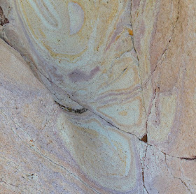
There was the plan and off I went. I first headed up a side canyon of the Lower Faulkner Box and then up over some hills and a ridge, and then it was down very steeply into what I would end up calling A+B Canyon. Most of the area's geology is composed of basalts, andesites, and ash deposits. At the bottom I found this boulder with deep crisscrossing crevices which reminded me of turtle shell. I headed upstream and soon encountered a large dry waterfall which had carved many channels in the soft pale rock.
As always I looked around for grinding mortars and rock art, but neither was forthcoming. The waterfall was easily climbed around and I continued upstream. It was wonderfully sunny and peaceful in this little valley as I marched along on this late December morning. I soon realized the canyon was going box up in the dark brown varnish of the cliffs ahead of me.

As I climbed up the first of several smaller waterfalls I realized this canyon was like a mirror image of Lower Faulkner Box Canyon, which I had hiked a little over year ago, and whose high waterfall was only a stone's throw away. A + B Canyon's last waterfall was not nearly as high, and after I had climbed around it, I saw petroglyphs in the rock. These were pecked in for sure, but they were letters which relegated them to a fairly recent vintage. They did give me the name for the canyon, though.


After that I wandered up the shallow upper wash cut into the slopes of golden grass. I was tempted to go find the precipice of the other waterfall, but instead steeply climbed up the ridge on the west and began heading north. It was very rocky indeed up top and even rockier still as I descended a steep slope to a saddle where I picked up section of trail that headed more directly back to my vehicle. It faded quickly but soon after it did, amongst the tufted gray grass I spotted sherd after sherd of ancient brown pottery. There were many pieces,but they seemed to concentrated in one small area, which made me wonder if this was just a place where someone had dropped one pot. As I ventured out short distances in each direction in search of more,but finding none, I decided to go back to my original discovery. I panicked a bit when I realized,even though I had walked no more than 20 feet from it, how hard it was to find again. I did find it,but decided to build a little cairn that rose just a bit above the grass to aid me if I should return.
I continued along this mostly flat, mostly cleared mesa with my eyes to the ground, and thought of how when I'm looking for something small I ( like sherds or fossils) I might miss something big( like a mano or metate) or when I'm looking for something big like rock art, a mine,or grind holes I might miss many small things. It began to seem like destiny that I find anything at all,but the happy part is that I do and it keeps me coming back to our desert for more.
NOTE: Although most of this hike is on Organ Mountains Desert Peaks National Monument, it begins and ends on State Trust Lands where a recreational permit is required.


No comments:
Post a Comment