|
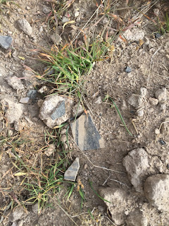
Pottery placed on building stone by a previous visitor that
I photographed. It is advised not to move any artifacts. |
|
 |
| Cerro Pedernal |
This hike is near Cañones, New Mexico. You will need to get a free permit, directions and interpretative information from the Coyote Ranger District of the Santa Fe National Forest. Do not do this hike or visit the ruins without a permit. Unlike many of the more well know pueblo and mission ruins that have easy access and sometimes crowds of visitors, this journey is more of an adventure and on the Saturday of a long weekend we were the only people there.
Similar to our hike on Cañones Creek in the summer, this one was only about 1.5 miles as the crow flies from the house we were staying at on Cañoncito Seco, yet, we had to drive the long way around to get to the trailhead. Much of the hour long trip was on the very rough FR 27 as it climbs around the south side of Cerro Pelon, down to Polvadera Creek and then back up onto Polvadera Mesa. An un-marked forest service road took us the last couple miles to the parking area. From there we began, on a cool, cloudy morning. We quickly were at the edge of the mesa and began working our way down slowly on the many switchbacks that cut roughly through the piñon, juniper and oak forest on the steep hillside. The views that occasionally opened up to Cerro Pedernal, Cañones Creek, Polvadera Creek and all the way out to the cliffs of the Chama River valley were incredible, but we had to keep our eyes more on our feet to negotiate the rocky trail.


I couldn't really figure out where we were headed at first because our destination was initially obscured by the trees, but finally I caught a glimpse of the trail off the in the distance where it crosses a narrow, little land bridge that connects Polvadera Mesa to the Mesa del Pueblo. The look of it, because it seemed to skirt a sheer cliff on one side, made my wife uneasy, but when we got there it wasn't all that bad. We later learned that section was part of an original trail used by the ancients.


Now we descended as we circled around the highpoint of the smaller mesa where there were some amusing rock formations. Finally we caught sight of some crude rock walls ahead and we knew we were close to our destination. At the walls, where we rested a moment, there were fantastic views looking upstream of the Cañones Creek valley with its green fields and golden cottonwoods. We followed a footpath worn in the soft volcanic tuff as it wound through the towers of rock left standing in the wake of the prehistoric quarrying operation that went on there.
Soon we were in the midst of the huge piles of cut and shaped stones that are the ruins of what was once a substantial pueblo of 1500 rooms that may have housed as many as 1000 people. Painted black on white pottery lay everywhere on the ground, which was fascinating for both of us as we a had never visited a site where it was in abundance like this.
We soon came upon one of many smaller kivas that were carved in the bedrock. Once used for ceremonies, they are now filled with dirt, shrubs and weeds.
Good sized piñons grew with tufts of grass in what was once the open plaza. Stones set in square shapes had trees growing out of them that weren't there hundreds of years ago.
Very few room walls are standing, but each time we found one of the few that are, it seemed like witnessing a minor miracle. They were good masons back then nearly 800 years ago, but the mortar made only of mud did not preserve their handiwork.


Off by itself, separated by more than a hundred yards from the rest of pueblo structures was the great kiva which was partially carved, and partially built with large mortared, but only crudely shaped stones, unlike the careful bricks of the rest of the pueblo. Cerro Pedernal, perhaps the source of the agate, chert and flint that lay on the ground was in view directly to the west. On our way back through the pueblo, we came upon some stairs carved into the bedrock, that would have led down to the lower rooms of the pueblo which sat on a bench just below the flat mesa top. At the edge of the bench were sheer cliffs of pock marked volcanic rock that are found all over the region.
 |
| Great kiva |
We could see storm clouds forming over the high country to the south, and thought it prudent begin our return trip even though both of us wanted to linger at this fascinating place. It definitely exceeded both of our expectations and though I won't bore you with all the questions we thought of while wandering the ruins left behind by people not so different from you and I, I will say there is certain lightness of being that comes with the magic of perspective.
Labels: hiking


