 |
| Massacre Peak |
 |
| Looking toward Fluorite Ridge |
I wrote about this place a couple years ago( check the archives) which is when I realized that I didn't have a single photograph of the wonderful rock art site here. This past Sunday(2/1/15) we came back. This was the fourth time we'd been here, but the first time in more than ten years. Nothing much has changed. Driving over the dam across Starvation Draw was a little more sketchy, and in not too many more years I could see it not being usable at all unless repaired. We parked a little bit beyond the dam, right before a rough patch on a steep hill.. In the past we've driven the low road on the southside which follows the arroyo more closely in the flatlands. On Sunday we walked the ridge road that runs on the north side( stay left after crossing the dam) out to the Frying Pan Canyon dam.This is probably the preferable alternative as it stays dry high above the wash, although it eventually connects to the low road probably a half mile or so before the dam. At the point of the stream crossing, we started walking a more direct route east toward the Frying Pan dam and the adjacent rocky hill on its northside( our destination). It was easy walking between the creosote and mesquite along the cow paths. The hike was probably two miles or so from our parked truck( near the Starvation Draw dam) to the Frying Pan dam( one way).
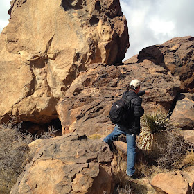
We picknicked at a flat spot of sandstone ( or volcanic rock that very closely resembles sandstone) near a large juniper, with several ancient grinding holes right beside us, and then we started up the hill to where the petroglyphs lay. One thing different about this rock art site is that although there is the patina of desert varnish, the rock is not smooth at all,but ribbed and gritty. We wandered around, on top, and even under and in between the maze created amongst the huge( house sized) boulders. There were shelter alcoves, more and more grinding holes, narrow passages,and in every conceivable lie hundreds of petroglyphs. Going through a tunnel of some scrub oak, I emerged to find, the site's most well known glyph: a wonderfully convoluted image of Tlaloc. There is abundance of foot glyphs here: human, cat, bird, bear and others. There are fish renderings , lizards, many snakes, antelope and the human/ animal that is the horned serpent. There are also many delightfully small masks in several out of the way spots, which had the feel of being rendered by the same artist. There are many crosses as well,which may have been after contact or observation of the Spaniards ( some say these are not crosses at all but images of the western star, the planet Venus), although there are no etchings of horse and rider as at other sites.
The unseasonably warm February weather and light were perfect, and I had wonderfully mellow feeling until, after photographing one last panel at the bottom of the hill I realized I hadn't put the SD card in the camera. In a bit of Groundhog Day comedy, I ended racing back up the hill and retracing my journey snapping photos at breakneck speed. The light wasn't the same, but it all worked out. We made it back to the car along the same road . Eyes on the ground, I noticed the myriad of colors in both crystalline and the cryptocrystalline samples of quartz that lay everywhere.


Nice photos and documentation of an area that's not talked about enough. My family and I would like to visit this weekend. How close do you reckon a Subaru or vehicle without high clearance could get to the petroglyph area?
ReplyDeleteThe dam has across starvation draw has one spot that's pretty bad. After crossing, I can't really speak for the condition of the road to your right. We used to be able to drive all the way to the site on it, but we had high clearance.Even if it hasn't worsened in 10 years, it's not fun and a very slow drive. The road on your left has one really rough hill early on, which I would not take my sedan on for sure, but after that is in good shape and could be used to get to within a 1/2 mile or so, or if you cross the arroyo it will hook-up with the other road and take you right there. I hesitate to recommend driving a low clearance sedan, the subaru might do ok, if you take it real slow and careful you might be able to make it. Otherwise you are looking at a 2-2.5 mile hike( one way)
ReplyDeleteOK thanks. Sounds like it will be at least a 5 mile hike which I was expecting. We've been to Flourite Ridge and up Cooke's Peak, so it will be nice to continue filling in all of the gaps of interesting sites within the Cooke's Range.
ReplyDeleteI forgot to mention that there is another great petroglyph site at pony hills which is on the main county road at the second dam and can definitely be driven to with any vehicle( it's probably only about 2 miles past fluorite ridge).
ReplyDeletePony Hills is also on the radar, and we may settle for that if we can't encourage the kids to do 5 RT miles. My assumption was that Fryingpan Canyon was more spectacular, but we really shouldn't be too picky..
ReplyDeleteFrying pan is more of an adventure which is more fun. I wouldn't say the art is any better though, each has it charms.
ReplyDelete