Sunday, November 30, 2014

Robledo Mountains Wilderness, " Middle" Canyon- Organ Mountains -Desert Peaks National Monument


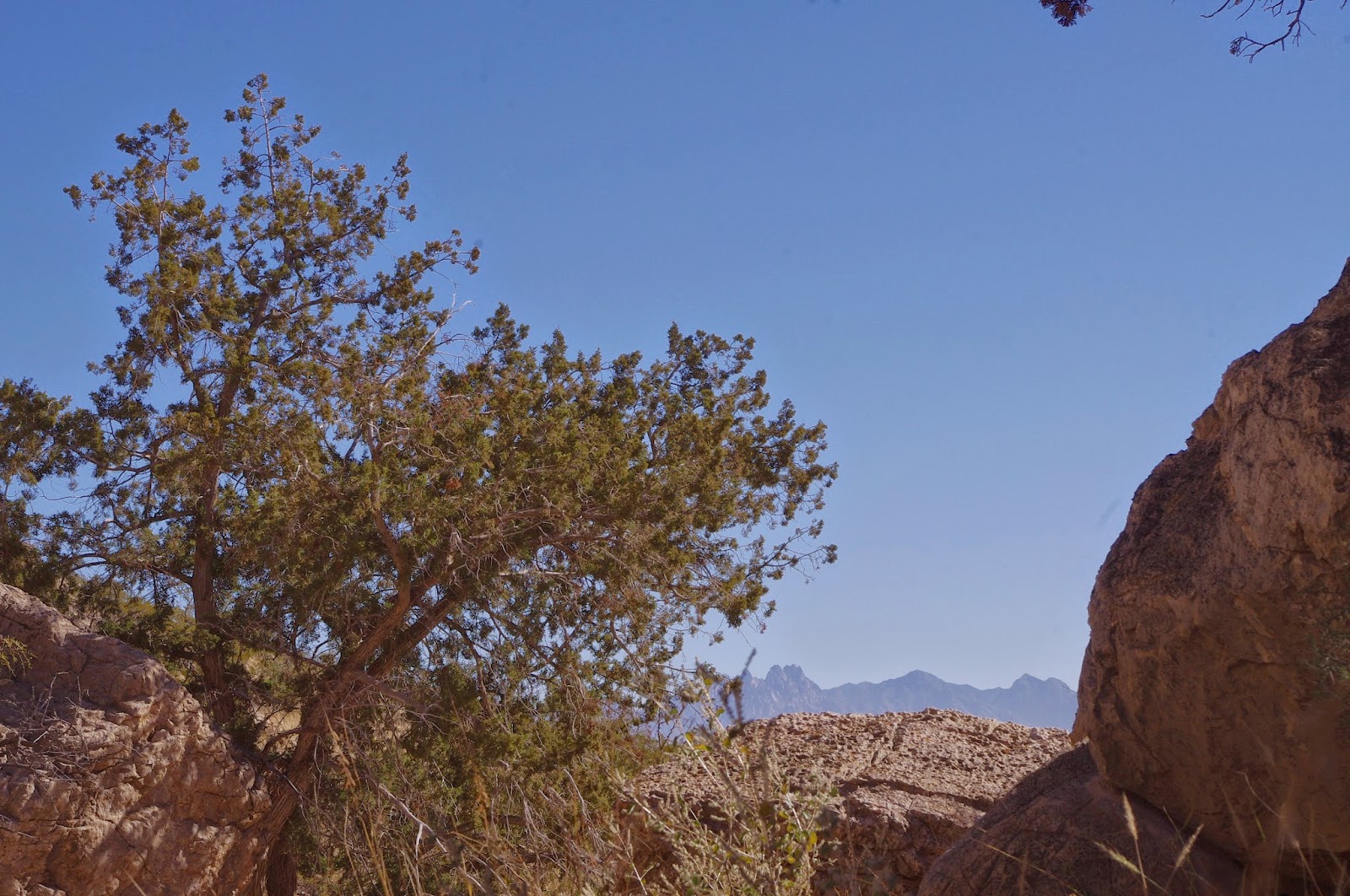
Organ Peaks in the distance

tombstone rock


Looking back from the wash. Middle Canyon is left center

Juniper roots splitting a boulder.

Last year, close to this time, I visited the west side of the Robledos. I went back yesterday to the same area only this time I headed for the canyon just to south of the one we went into last year. I'm calling this one " Middle" Canyon because it's the middle one of the three larger canyons on the west of the Robledos south of Robledo Peak and north of Trackways Canyon. The north one I called Big Canyon (see blog about it from December, 2013). The south one I visited many years ago (see "Slot Canyons" in this blog for photos). It's the largest of the three and I recall it had a short slot section.
   I reached the Middle Canyon by  beginning on the same route as last year. After crossing the Rio Grande , we followed  small arroyo and then crossed over a low ridge into the big wash that is fed by  Big Canyon. We walked up the wash  a short ways and then climbed on a visible deer trail onto the next ridge. Heading south and then east, we found a gully that took us down steeply into Middle Canyon.
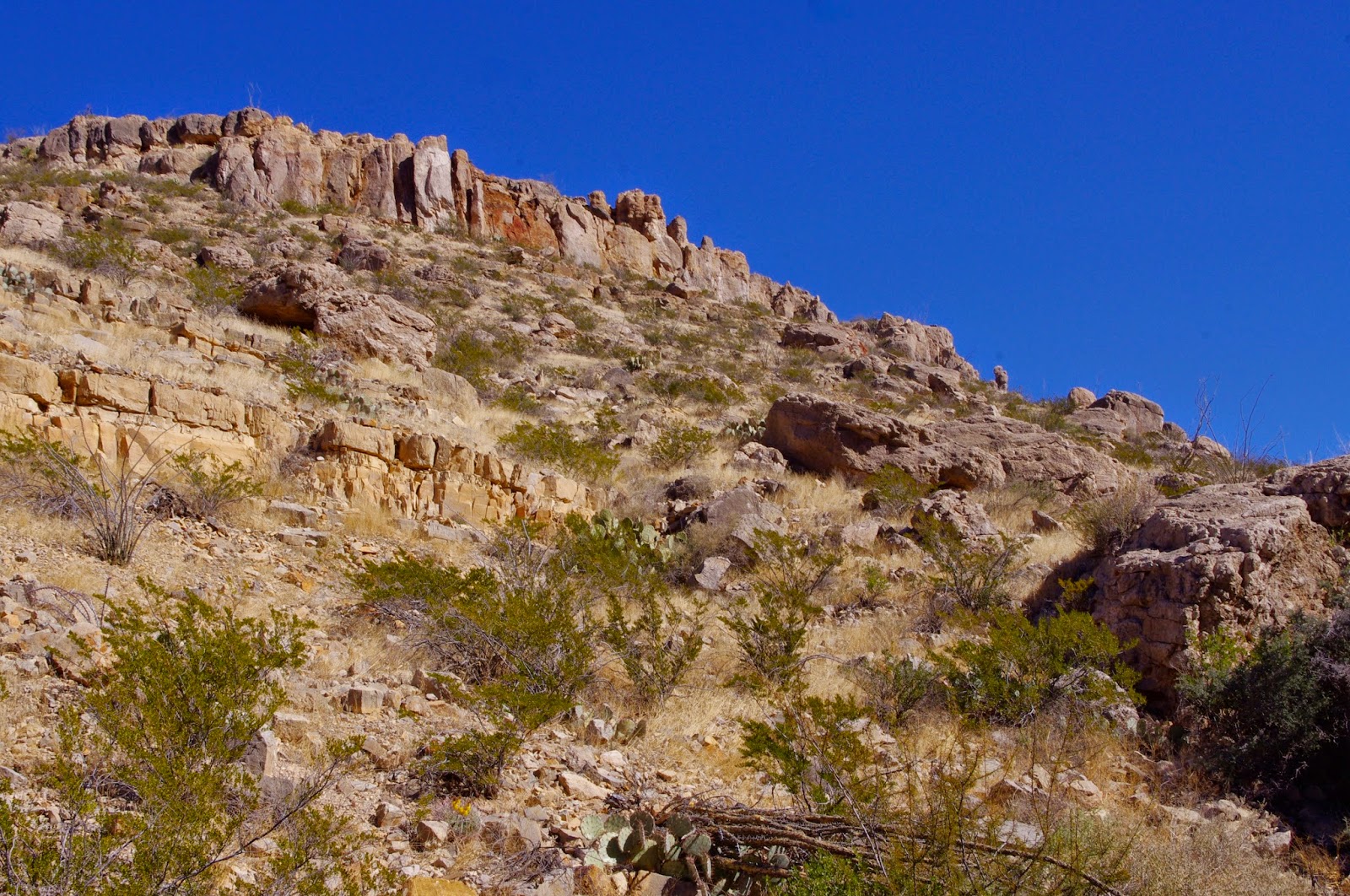
This canyon is marked by small  rock tower that forms a notch on the peak on the north side. Down in the canyon it was a lot of rock hopping amongst the limestone and other sedimentary boulders. This canyon is not as narrow or as steep as Big Canyon so there was also some easier walking on the gravel stream bottom, and  a few sections of slabby bedrock as well.
    There are many large desert junipers( some truly outstanding) down here, both living and dead, as well as  all the typical shrubs one finds in the Robledos.  The  rocky hillsides were sparse with creosote, weeds, and grasses.


   We were able to penetrate much further into this canyon than into Big Canyon, eventually stopping at promontory that split the  canyon into two arroyos. Both branches had small dry waterfalls that could be climbed or walked around with modest effort, but it was quite hot for the second to last day of November, and the upper reaches were shallow and shadeless, so it seemed like a good spot for the turnaround. That being said, with little more time and effort one could  perhaps connect with the South Canyon by going over a relatively low ridge at the top and make this into a loop.


On the way back we explored a large side canyon on the south side. In the cliffs were small alcoves and perhaps openings to small caves. At the dry waterfall where where we stopped, it  was dark and cool even at high noon. I had the  feeling we were in or near a collapsed cave. Formations in the pockets on the cliffs had the look of processes only found in caves. A fantasy began to grow in my mind,as it usually does when hiking these pock-marked  canyons,of discovering a beautiful cavern in the Robledos.  I wondered if folks have even been actively looking, or have looked and given up.

 We  made our way back down, this time continuing in the entrenched arroyo of Middle Canyon rather than going the way we had come. It eventually lead us to the large wash that is fed by both Big and Middle Canyon, where we walked on first one and then another of the many gravel beds that lead back to the Rio Grande. There is some posted "No Trespassing" private property in this area.We had to climb a couple of unposted barbed wire fences as well. If one walks far enough to the north on the road( along the second fence) , or cross country( along the first fence),  the fences can be bypassed altogether, but my truck was straight ahead across the river, so I climbed and Seamus went under.  Let me repeat,I did not climb over any  fence that was posted "No Trespassing"  and if you go you shouldn't either.

 This wasn't a spectacular hike for me. The scenery was not nearly as inspiring as nearby Big Canyon with it's massive cliff faces.The most it has going for it is its wild and rough nature. It's hard to believe that humans of any era ever visited it with any frequency. Perhaps in the pursuit of prey, they came, or maybe  for some shade or a lingering pool of water. Close to where to we turned around in the main canyon. I spied a cairn on the hillside. We investigated. It wasn't a geocache nor were there any mining papers secured in a bottle. A few hundred yards away there was another one, a bit lower down. There are no trails out here. All I could figure was the  pods of iron minerals in  the rock here had interested some long ago prospector, so he erected them to stake a claim. Still, I'm not sure. It's a bit of mystery. That's what makes exploring these kind of places fun,you just don't really know what you're going to find until you get out there.
The intrepid Seamus next to cairn we found.

Labels: ,

Point of Rocks


We wandered around these pointy little hills on a winter day quite  a few years ago Using some old roads at times, then going cross country, we made a loop heading first east, south, then northwest back to our truck parked along the Upham- Engle Road( now the Spaceport Road). Found a few old foundations,  a few prospects as well,their histories unknown to us. I have read that there is a rock art site here as well, perhaps a reason  to revisit another winter day. A lonely, forgotten place now,but it was part of the Jornada del Muerto stretch of the Camino Real.

Labels:

Tuesday, November 11, 2014

"A" Trail ( FT 119)- Lincoln National Forest


I didn't want to end my hiking day at just little after 2. I have a rule that the activity time should always be at least equivalent to the round trip driving time, so I headed  back downhill to the "A" Trail trailhead. I was  actually thinking about walking Trail 219( Hells Hole Trail), which looked to be a short little out and back that headed south from the same trailhead. I didn't notice any markers, so I took off on  FT 119 thinking I would see it soon. I didn't, but it was okay, because after only a very short walk, the "A" Trail was treating me to fantastic views down Hells Hole Canyon and Caballero Canyon on the south, and Dry Canyon on the north. Unlike the Gobbler Knob hike there was no waiting for big payoff.
  Initially, the trail climbs a small hill, but then levels out with only some very minor up and down for the next mile or so as it follows atop the narrow spine of  the ridge that extends as one of the many branches growing out from West Side mesa.  I knew that this was a trail that went all the way down to Alamogordo, but little else. I decided to walk along until it began going down hill in earnest, then I would turn around. So Seamus the Scottie and I just trucked along in the bright afternoon sun( should have brought my big hat). Further along views opened up of the city ( Alamogordo) below and all the way out to White Sands. In the far distance was Salinas Peak. The walking was easy for the most part. Even though this trail is open to motorized use, at least this section was not showing any signs of overuse or abuse. We just kept going a little further until we reached a meadow area I'd  been looking ahead at for much of the hike. It was a pretty spot. We rested a bit. I thought about climbing a small rocky peak on the meadow's northern edge, but didn't.  I had a strong feeling that not too far from here, the trail would begin its serious descent. Checking maps later, I was more or less right. If one wanted a little more of a " destination" for this hike, Ortega Peak is just little bit  beyond where I stopped and wouldn't be too taxing even for the casual hiker. We had hiked close to 50 minutes out there and by the time we got back, it was a quarter to 4 with the sun rapidly dropping. Good timing, and really the best part of this hiking day was spent on a trail I decided to walk down as afterthought. NOTE: Trail 219 is on the left at the 3-way intersection of 5574,119,219. For some really good info on this and other nearby areas, especially on the west side of the Lincoln, check out imike's trail descriptions of the hikearizona website.


views down to hells hole


Salinas Peak at left center

The meadow


Labels:

Monday, November 10, 2014

Upper Dry Canyon Loop Hike( Forest Trails 5574, 5574A,5573)- Lincoln National Forest


       I devised this little loop using trails off of the West Side Road ( FR 90). I started at the second( further south from High Rolls) Upper Dry  Canyon trailhead. This is also the upper trail head for the "A" Trail. In retrospect, it might have been better to start at the first Upper Dry Canyon trail head( north and closer to High Rolls) and made this a lollipop type loop. As it was the hike was  little too short, lasting only 2 1/2 hours.
  I started walking downhill on  a perfect fall day. Shortly, I passed FT 5573( Upper Dry Canyon) my return trail. Shortly thereafter, I came to the intersection of FT 5574( Dry Canyon) and FT 119 ( "A" Trail). I stayed to the right heading  down FT 5574. The upper end of this trail is mostly reddish sandstone rocks. Not big boulders mind you, but just big enough to necessitate watching your footing at all times. Along this stretch, you will see many small rocks with coatings of green malachite, blue azurite and other copper minerals. They have washed down from the many mines and prospects in the area. Most of the mines are well hidden in the pines, junipers and scrub, but I did encounter a small tailings pile further on, and there is  large reclaimed mine right at the beginning of this hike. There also several rough roads that branch off the main trail, that more than likely serviced these mines. 
 The trail continues down on the side of the  canyon among large pinons and stunted oaks. At intersection of 5574 and 5574A, I turned to the north on  FT 5574A which took us down to the stream bed and string of mature ponderosa pines that grown along it. There is an old rusted cattle drinker here and the  map says a spring is short ways upstream, but there was no water flowing where the trail crosses the creek.
 Now on FT 5574A we began climb back uphill. This section of the trail is pretty rough as well. I imagine only the most skilled of ATVers, motorcyclists and mountain bikers would want to mess with it. As it is it doesn't look like it gets much vehicle use, at least not anymore. I investigated a side road and then picnicked near where the trail crosses a small side drainage. Continuing uphill, I noticed the rocks in this section were mudstone that looked very much like the rocks that contain the Permian trackways over in the Robledo Mountains near Las Cruces., but didn't noticed any fossils.  I turned right( south) onto 5573 which  gave me an almost level  return leg as the wide trail headed nearly straight back to  where I  began. I noticed some huge juniper stumps amongst the younger trees. Maybe they were cut to provide fuel for the mining operations many years ago.


Labels: ,

Little Ice Canyon ( Dripping Springs Canyon)- Organ Mountains


 I emerged from the thicket in Ice Canyon, and with little or no hesitation proceeded on the trail that goes above the old hotel and sanitarium ruins to the small catchment pond that impounds water from Little Ice Canyon. On the way, I snapped a few photos of the lower falls which had a decent,but not spectacular flow. At the little falls above the pond( where, in warmer months, I've often wet down my clothes for the return hike) I saw several pairs of shoes under some brush. Rock climbers? I didn't know, but I decided to head on up the use trail to the wild, wild territory above the little falls.


         It is often the case that when I can't reach my destination or otherwise can't complete the hike I had planned, a need grows out of my dissatisfaction to do one more thing,one more bit of exploring before I call it day. It could a bit of scenic driving,  taking a different route back, or just taking a short side trip. On this day, it was heading up into the narrow box of Little Ice Canyon.
  I had been up there once before, many years ago, when I caught  a glimpse of red high up, and decided to investigate. I made it up to the first few maple trees, took in their blessings and retreated. This time I wasn't sure what I wanted. After a few hundred yards, a trail exited to the left. I took it, and was soon up on the ridge that divides  Big Ice from Little Ice. I got a great view of where I had just been climbing in  Big Ice. The section of cascades on bare rock was so steep, it appeared to be without depth.  Flat. Two dimensional. I couldn't see exactly where I had turned around, but the visual of  how little  horizontal distance I had covered was disheartening. Maybe I had given up too soon. Maybe that 30 foot waterfall was last one where I would have to cling to the cliff, or power through the brush to get around. Maybe I should have switched to the north side of the stream and the going would have been easier. Maybe, maybe, maybe. Maybe not.
Looking at Ice Canyon

 I climbed westward up to the high point  of the little ridge. Nice, but not enough. I ate my lunch looking eastward at the massive walls of the canyon. As I was finishing. I heard voices from up there. I went back down to the little flowing stream and headed up. After negotiating a slippery area of slabby bedrock. I came upon three teenage boys, barefoot, standing by deep pool of clear, cold water, which was being fed by a thin, sinuous cascade that flowed down from the darkest, narrowest section of canyon above.


 The boys had thought bare feet would more easily handle the terrain better than their slip on Nikes. They had been up above the cascade, but the rock had gotten increasingly sharp. The lichen and moss had also made the footing  tricky.  I told them I had heard of a passage from this canyon( with much climbing I'm sure) over into Bar Canyon( Soledad tributary). They were incredulous, not so much that such a route existed, but perhaps that anybody would want to do it. They may haven't gotten the impression that that was my plan (it wasn't). They wished me good luck and headed down. I thought if they could do it so can I.
                                                                       The  Fall
 Even though I had carefully planned practically every step I took over in Big Ice, no sooner had the boys left my sight, I found myself powering my way up the smooth rock on the left (north) side of the waterfall. It was very steep, but I thought to myself, this is easier than I thought. Now of course,  when someone thinks that you know what's coming. At the very top of the cascade (it seemed like the top but it was hard for me to tell), it got a little bit steeper. And then there was the hump. A small hump for sure, but with nary a place to get even a finger hold. I felt myself slipping down, only not the way I came, but toward the water. I panicked a little. I  really wasn't going to make it up, not only that, but I was going to fall. I felt it would be best to turn around  for some reason (perhaps to be facing my fate). It was difficult, but I managed it. I enjoyed my success for a second or so and then gravity and the lack of friction took over and I began to slide towards the water.  I accelerated rapidly, probably went airborne briefly, and then landed flat on my back in the waterfall, my backpack with my denim jacket threaded through it, helping to break my fall. Luckily, there was break in the vertical and I was able to stop myself from ending up in the pool at the bottom.  I took off my backpack and tossed it to dry rock below. I carefully eased myself out of the little pool, watching the gush of water  I was holding back erupt from underneath me as I lifted up. Slowly, I shifted onto the smooth dry rock on my right and made my way down without further incident.The whole time this was happening, my phone was ringing.


 My phone wasn't wet or damaged as I carry it in the front pocket. I called my wife. Didn't tell her what had just happened. I had some pain on my right thigh and hip socket, but other than that I was alright. Wet, but alright. I looked at the waterfall. Just above the pool, stuck, with the water running over it, was my hiking pole. I thought about retrieving it, but it would've meant taking off shoes, socks and pants. I was wet, but I didn't need to get soaked. Strangely enough I found myself looking back up at the rock beside the waterfall, thinking that perhaps a route further to the left would have been better. Thinking I should have asked the boys how they managed it. Much later it on, thinking on those photos I've seen, it occurs to me that in dry times the crack the waterfall has made in the rock at its top might be the easiest route of all. I could feel something inside burning to give it another shot. Wisely, the voice that said "no, not today" won out. Now I felt myself giving in again to the idea of hiking with companions especially when attempting something ridiculously off trail such as this. I felt stupid.  I thought about how mortified I would have been if I had needed rescuing. All along, I had intended to invite a comrade, but never brought myself to do it. I'm pretty much a loner when it comes to the outdoors, but now it may be time to break that habit, at least some of the time. I picked up my wet jacket and began to make my way down. Before I left I noticed some faint graffiti on the side of the pool. Kids probably come here in the summer to get wet and maybe even slide into the pool on purpose. With that bit of perspective, I was done with the place for that day.


    At some maples, lower down I snapped a few pictures. The boys were only a short ways ahead of me. Part of me wanted to catch up and tell them what had happened, part of me didn't. The whole episode  on the waterfall had lasted maybe a minute or two, but that's enough. It was cool and overcast as I hiked back. As I got in my car, it started to rain. NOTE: As with upper Ice Canyon, Little Ice Canyon above the little cascade has been posted with signs warning that you are trespassing on military property. Enter at your own risk. This area is not part of Organ Mountains/ Desert Peaks National Monument


Labels: ,