 |
| Lucero Canyon |
 |
| Lucero Canyon |
 |
| Lucero Canyon |
 |
| Lucero Canyon |
 |
| Lucero Canyon |
 |
| Summerford Mountain area petroglyph panel |
 |
| Summerford Mountain area petroglyph |
 |
| Summerford Mountain area petroglyph |
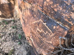
I first heard about Lucero Canyon petroglyph site in a book or newspaper article which mentioned it by name and that it was in Doña Ana County. No other clue was given. I found a Lucero Canyon in the Doña Ana Mountains on a topo or some other map that I had and so I set out on a warm, late summer evening to see what I could find. Parking at the Radium Springs exit on I- 25, I soon found my way into what I believed was the right canyon and started walking up stream. There were some dry water falls and a few fossils in the gray sedimentary rock. The canyon looked very much like ones I'd hiked in the Robledos, a range made up mostly ( but not entirely)of Permian limestone and sandstone. This seemed an oddity because the canyon drained the entirely igneous Doña Ana Mountains( I later learned that faulting on northwest edge of the range has resulted Permian era sedimentary surface geology). I had probably walked around two miles and was beginning to despair of finding anything before the light faded, when the canyon walls rose and closed in a bit, and the rock had that right patina of desert varnish prized by those ancient artists, and soon I was finding images everywhere: a hunter with bow and arrow and his antelope prey, a turtle, strange light bulb- headed twins, abstracts, and more. I probably saw less than half of what the canyon had to offer that first time, before I decided to return not wanting to stumble around in total darkness. I was elated to have "found" the rock art. This was only the first or second time I had set out find a site without any real directions and I felt quite proud myself for the accomplishment. On two subsequent visits with the family, we found even more petroglyphs and even saw some evidence of rock art theft. We met a large blacktail rattler on a November hike, and had four huge great horned owls fly inches over our heads on another hike in early fall.


 |
| Lucero Canyon |


My wife and I had done a hike that encircled nearby Summerford Mountain on an April day that was bit too hot. I was looking for petroglyphs and grinding mortars I had seen in catalog of images from the Dona Ana County Archeological Society. We didn't find anything. My mind frequently drifted to thoughts of climbing the steep and isolated little mountain of pink rock. I could see myself in the shade of the junipers that dotted the ridgeline. On a solo trip in winter I parked near the pass that lies between Summerford Mountain and two detached outcrops that lie immediately to the west. I began exploring around the north side of these peaks and began to find petroglyphs on isolated boulders, as well as mortar holes in alcoves of massive leaning slabs of pink rock that must have been used for shelter by ancient peoples. This was another very exciting trip and I have always wanted to return. IMPORTANT NOTE: Both these hikes require crossing NMSU property. At the time I made these trips, gates were left unlocked and permission was not needed to access these sites. Sometime in the mid to late 2000s, vandalism to scientific experiments in other locations on the property prompted NMSU to lock the gates and to require permission to be granted for any entrance onto the property. This may still be the case. I have not visited these areas in many years,but advise anyone trying to do so to contact the BLM and NMSU first.


What a nice write up, and great pics to accompany it, too! My husband, our dear friend, and I hiked Lucero “Canyon” or wash the day we were married in December 1995. It was spectacular! A friend just spoke of a location on China Lake,, Coso Rock art. If you’ve not been there, and are still out hunting art,,, sounds intriguing! Thank you!
ReplyDelete