Saturday, May 26, 2012

South Fork Bonito Creek, LIncoln National Forest-May -2012

 I went back to the South Fork Bonito Creek hoping to hook up with a few of those trout I saw back in September. One thing I'm beginning to learn: the fish always look bigger when you're not fishing.  I have fished the lower 2 miles above the campground so many times, I decided to not to even  unpack my rod until I had hiked in an hour or so.There are plenty of fish in these further reaches of the stream. Most seem to be brookies and and most are small. I was hoping for few better sized rainbows, but only caught one very small one. Instead it was just one eager 5-7 inch brookie after another, which can get old after awhile. The prize of the day: a nine inch brook char that I had to work for by getting the little ones out of the way and depositing them in the pool behind me. The South Fork is  a beautiful little stream and can be a fun place to fish, but I'm feeling a little jaded. It hasn't been in real prime condition for several years now with good flows and better sized fish. One thing I did learn on this trip is that the brookies are there as far upstream as four miles from the trailhead and maybe farther when there's good water. I turned around near a spot where the stream went underground in a football field sized area of bare rocks and stones probably caused by a flooding event that stripped away all the soil and plants or by rock slide or a combination of the two.There is one of these stretches lower  down just above the wilderness boundary as well which is in a more advanced state of recovery. That's the odd thing about these streams around Sierra Blanca. The big and frequent floods and subsequent erosion  carves out much larger channels than are needed for the small average flows. IMPORTANT UPDATE: (May, 2014): the entire South Fork Bonito drainage was within the Little Bear Fire burn. Check with the Forest Service for conditions.  I suspect the fish population  is no more. Trout fishing in the southern half of our state may becoming a thing of the past sooner rather than later. UPDATE:  I have been told that there are still fish in the South Fork Bonito. I suspect brookies, rainbows and hybrids like before the fire, but I don't know about the numbers, or if it really is a "fishable"stream anymore.
Trail 19 before the Bear Fire

Labels:

Monday, May 21, 2012

Little Creek-Gila Wilderness


 I think I've fished Little Creek four times: twice in the spring and twice in the fall. The first outing I caught three small fish,but I was nonetheless elated because these were my very first brown trout. The next time out was one of my biggest days  in the Gila.  Somewhere between 12-15 browns came to hand that day including one skinny one that was at least 18 inches or so.That one was caught in a narrow run through some bedrock that couldn't have been more than 2 feet wide, which made its size all the more preposterous. The next trip yielded a single trout. The last visit, the water was low and warm and all I saw were suckers and shiners for most of the day and what I caught was nothing. I did see a few Gila trout right before I turned around in a particularly claustrophobic, boxed in, overgrown section of the stream.
There isn't any official trail on Little Creek and use trails kind of come and go, but you can't get lost: there's nowhere to go but the stream bottom in this canyon that almost immediately "boxes up" soon after you begin hiking from NM 15. I've only met one couple on one of my trips. They were surprised as are most of the very few people I've met while fishing, that there would be any fish worth catching in this very small creek.Each time, after finishing my day at Little Creek, I've tried my luck in the stretch  West Fork of the Gila(where Little Creek empties ) up and down for a 1/2 mile or so from the Little Creek bridge, but never with any success, no bites, no sightings, nothing. Note: At some point further upstream than I've ever been there is a fish barrier. This indicates the beginning of the Gila Trout water and the end of the legal fishing.


Labels:

Monday, May 14, 2012

Mimbres Lake, Aldo Leopold Wilderness,Gila NF


 We did the Mimbres Lake hike from Laurence Parent's Hiking New Mexico a few years back. We timed it perfectly for the fall aspen display on Mcknight Mountain. It was a our first time driving all the way to the crest on the legendarily awful McKnight Road ( FS 152). It took close to an hour to drive the last 10 or so miles. In retrospect it probably isn't the best idea for  a dayhike, unless perhaps you live a little closer than Las Cruces. Even then it's pretty iffy proposition.The hike was definitely less exhausting than the drive, although it had a few steep spots especially where it follows the old fire road. It also had some very inconvenient downfall.  A short ways in we took the little side trail which allowed us to make the very minor ascent to one of the two "peaks" of Mcknight Mountain( the highest point in the Black Range).Tremendous view were all around the rocky little summit.


Further on there are some of the largest douglas firs and aspens to be seen in the whole Gila just before the trail descends to the lake. I wish I'd been more of photo junky back then because I can't find a single shot of these massive trees anywhere in the archives. Hopefully I'll make it back someday. The lake was more of a mud puddle on our trip (which may be another good reason to return as well) but the aspens around it were beautiful- a truly perfect spot to camp on a backpack. I peaked down the North Seco trail (FT 110) which intersects the Crest Trail(FT 79 the trail we were using) here. It looked very dark, wild and a bit forbidding. I could feel the  Crest Trail calling northward but alas, we had to leave and have our bones rattled on the return to pavement and civilization. UPDATE (June, 2013): The  trail conditions and scenery as described here may be vastly altered by the Silver Fire

Labels:

Saturday, May 12, 2012

North Fork Mimbres River, Reeds Peak-Aldo Leopold Wilderness

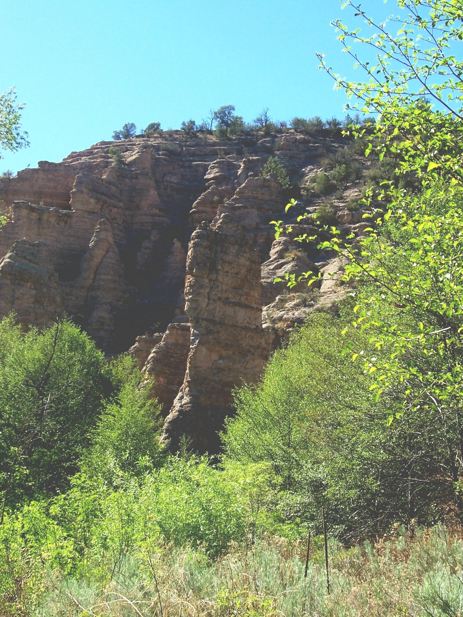
Cliffs above the North Fork Mimbres

Intrepid Angler

View south to Hillsboro Peak
Black Range Crest

Reeds Peak Lookout

Reeds Peak Cabin
 We've backpacked to Mimbres River in the Aldo Leopold Wilderness three times. That third time back  in '04, I had my closest encounter with a bear( less than 20 feet I'm guessing) while I was quietly fishing the stream our first afternoon there. If you don't know this already let me tell you: bears can be very quiet. So sometimes when you hear something that you think is a squirrel or bird, look up anyway. After a mutual scare we headed in opposite directions.  The bear went  back across the stream,  running into a  big cottonwood  in his hurry. I headed back to our camp  where my my wife was napping near our as yet unpacked and unhung food supply.  The bear came through camp an hour or so  later while we were cooking on the opposite side of the river from our tent. We yelled and blew whistles. Eventually,he got the idea to leave and headed up the hillside.
     The next day we did one of the best hikes in the  Black Range: the North Fork of the Mimbres to Reeds Peak. This is the real backcountry of the Aldo Leopold. It is not accessible as a day hike, unless your idea of day hike runs about 24 miles out and back. Even as it was, starting from  well in on the main Mimbres, we probably hiked close to 12 miles round trip. I fished a little as we went and caught a few small trout in the main stem and on the North Fork. Initially  the  North Fork's canyon is very narrow and boxed in. The trail (FT 77)  even  follows a ledge in the cliff sides at one point. Later, We had to hike a steep hill to circumvent a very narrow, rocky section that would've had us walking in the water. Descending the other side,  we entered a relatively wide open valley with tall grass and huge Douglas firs and ponderosa pines, where the tiny stream gently meandered.Further back there was a marshy area with several springs, where we ate and rested. Further back still, the trail left the stream and we began the truck up to  Reeds Peak.
      Shortly after passing a muddy spring trickling down the hillside and across the trail, we reached the crest of the Black Range with views opening up to the east.  There may be downfall in this frequently burned area  to the  south of peak. The trail gets a bit thick with low growing brush with the  last few switchbacks to the peak. 

On top there is the old lookout tower and cabin. There is also a cistern where we filtered water for our bottles. The cabin didn't look real inviting, unless you're a mouse lover, but it would probably seem very cozy if you needed to get out of the wind, rain or cold. The lookout tower's steps looked a little rickety and the last flight beneath the cabin is missing completely, so we didn't climb up. I don't  believe this one has been manned in many years. When we  got back to camp, we were thoroughly exhausted but happy to have left our prints, however briefly, on this remote canyon and peak of the Gila.IMPORTANT NOTE:  This hike is within the Silver Fire burn area and is vastly altered from the photos you see here. UPDATE (6/22): This is area is being burned again by the Black Fire

Labels: , ,

Sunday, May 6, 2012

Turkey Run,Diamond Creek- Gila National Forest


Turkey Run

Trail 42 above Diamond Creek

Diamond Creek

Trail 42, Diamond Peak

Forest Road 500, Turkey Run
     IMPORTATN UPDATE (6/22): The Black Fire has burned through the Turkey Run and Diamond Creek valleys. They are most likely vastly different from what is pictured and described here.
One July, seven or eight years ago we drove out to Gilita Campground. On the way up, we had the unfortunate luck to encounter a large camper coming the other way on the very, very narrow Mogollon Road ( NM 159). Luckily we  were on the inside "lane" and were able to back up to a slightly wider spot on a bend of the road. As it was, the other vehicle's large fixed side mirror cleared my own by about 1 inch. We arrived at Gilita in drizzly,humid weather only to realize we'd forgotten the bag of tent poles. After concluding that improvising with various pine branches was not going to work, we did a short hike along the creek and then headed home : this time heading east toward Winston and I-25. We stopped at Wolf Hollow to cook dinner. It was a strange day: eight hours of driving in a huge loop around and through the Gila for a short hike and a picnic. We did see elk, deer, antelope, coyotes and bear in the vast grassland on the north boundary of the Gila Wilderness. Arriving home, we realized our cat had been locked in a closet. Since we had been planning to be gone 5 days, we decided it was all for the best that the tent poles had been left behind.
    Anyway, after a good night's rest, the next day we headed out for Turkey Run, a small, remote creek that forms the northeast border of the Aldo Leopold Wilderness. It was long drive on increasingly lower standard roads once  we left paved NM 59 at the Lookout Mountain turn-off, but eventually we found a suitable spot and set up camp. In the morning I saw elk along the road. One evening we saw a  mama bear and 2 cubs scamper up a nearby hillside. We hiked up the road with our dogs to the springs that are the headwaters of Turkey Run. Two consecutive days we did the short hike down to Diamond Creek, venturing downstream one day and upstream another.   We relaxed creek side one afternoon, and I fed black flies to the hungry Gila trout in the shallow pools. The summer  monsoon rains had started recently, but the creeks were still very low. 


It threatened rain every evening, but never amounted to anything. The deep puddles in the undulating Turkey Run road(FR 500) that we drove through on the way in were all but dry by the time we left. On the way back we took a side trip to Monument Park along Chloride Creek for a picnic. We saw several long abandoned homesteads and I saved a bat from drowning as he flailed away in a metal water tank. It was a good trip, but this area is so remote, it requires a substantial commitment of time, because once you've made the long drive, you'll want to stay a few days to recover before heading out.
Monument Park


Labels: ,