

I had several misadventures trying to find my way into Indian Hollow
during the first few years I lived in Las Cruces. One hiking guide book had
us starting out at a pullout a short ways east of the group use area. We
went cross country over a hill, across a cattle pasture and eventually
ended up at a fence as we struggled through the brush. Another book had
us branching off the southwest corner of the Pine Tree Trail, going
high on the slopes and then dropping down into, a brushy, rocky
drainage.When we came to a high waterfall we had to climb up the slope
just to continue our way down, and in the process found an actual trail on a dividing ridge. I
fell hard on the ice high in the canyon on that trek, but at least now I
knew a trail existed- and where it began because I followed it
all the way back to the group camping area. Now things aren't so
hard.There's one of those yellow WARNING signs on the south side of the
group area parking lot at Aguirre Springs that will clue you in to
where the trail is. It goes through the fence and continues down the
arroyo before taking you up the slope on the south side. There is a
section that goes over some bare rock as it sidehills toward a bouldery
pass where one has to perform some minor climbing on bedrock.This
part of the trail might seem slightly daunting to those less
experienced. It does get better. After going over a saddle where there
is a large vein of rusty quartz that may be has just a tiny trace of gold. The trail continues along the side of the
hill, up and down and in and out of some minor drainages. At one of
these it may be easy to lose it, unless there are some thoughtful
cairns to guide you. Just keep a southwest bearing though, and you'll probably find the path again.


Eventually the trail parallels and then crosses the major stream bed out
of Indian Hollow and begins to climb very steeply on a dividing
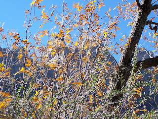
ridge.There are many small delights along the way especially if there is
running water. In the fall, it's fun to get a peek at some of the very few aspens in the Organ
Mountains. They grow in a gully on the northeast slope of Sugarloaf
Peak. I've taken the short but somewhat treacherous side trip several
times to get a closer look. The trail keeps going higher and higher,
steep, then steeper on loose granite grus that's even less fun to walk
on on the way down.At the highest point amongst the pines, Gambel's Oaks,
and Douglas Firs, I've frequently heard voices high up on the
exfoliation dome that is Sugarloaf. I've also seen the climbers, so
tiny, on the gray-white stone maneuvering their way to the top. From this highpoint the trail continues down hill to cross a branch of the creek and then
enters one of the most enchanted areas of the Organs. Here, there are large
pines that we've picnicked under and a few huge old cottonwoods, that
dazzle in the fall, lie along the stream which frequently has water.
Organ Needle and the other high peaks seem tantalizingly close, but just
out of reach.The trail continues back following the other branch of
Indian Hollow, but eventually just peters out in the cool shadows of the
ridgeline. Once we followed some old cairns, there was no tread, and
somehow scrambled back to the Pine Tree Trail. It wasn't easy or
particularly fun, although we did see some fantastic waterfalls that
literally gushed right out of the rock. It's a toss-up between this trail
and Fillmore Canyon as to which is my favorite. Both used be to be
enjoyed in perfect quiet as well, but the last time we came through
here, we met a woman with unfriendly, unleashed dogs( she didn't have a
leash either) and had to listen to some geocachers shouting at each
other every time they lost the trail, which was frequent enough that I
was tempted to walk back down and guide them just to not have to listen
to them. Oh, well I guess I was in their shoes once, I just didn't do a
lot of shouting.


Labels: hiking, Organ Mountains/Desert Peaks National Monument


4 Comments:
It there any way that Indian Hollow and Filmore Canyon connect?
Depends on what you mean by "connect." You can go up over the dividing ridge at the very back of Fillmore. It's very steep, and not particularly fun.Then come down the very, very steep east side into Indian Hollow. I've been up to that ridge,but never arranged for a shuttle so that I could go over. You're looking at a 7-8 mile hike( one way) with close to 2500 feet of elevation gain. It's doable,but I would give myself at least 6 or more hours to do it. Fillmore is a very nice hike just by itself, as is Indian Hollow.
We made it up and over today. It was very, very hard for about an hour and a half - included some crawling up and a bit of whining on my part. There was no trail or at least we never found one until we got up to the ridge just before the saddle and we found a cairn. We did flag where we went just in case we didn't make it and had to turn around. We left the Acquirre Springs group campground at 8 am and were at the saddle at noon. It was tough but my friend and I made it (I'm 50, not in the greatest shape but we've been hiking for years and she is ~65 and in better shape than I). We were at Dripping Springs La Cueva group area at 3 pm. So 7 hours that included about 1/2 an hour at the top for lunch. Feel quite good now:). Glad we did it on a beautiful cool morning and glad we missed the bad winds this afternoon. Weather wise we were lucky!
I should correct this - we followed Indian Hollow trail as far as we could and then struck out west ward toward the saddle. That is where we left pink flagging on some of the trees.
Post a Comment
Subscribe to Post Comments [Atom]
<< Home